Property Record
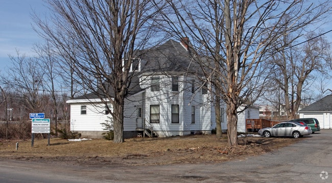
941 S 1St St, Fulton, NY 13069
Property Detail
941 S 1St St
Syracuse, NY
Oswego
355800-253-012-0002-001-000-0000
New York
Commercialofficeresidentialmixeduse
0.67 AC
I-1
Oswego County
B and X Area of moderate flood hazard, usually the area between the limits of the 100-year and 500-year floods.
Syracuse
4,382 SF
NEARBY LISTINGS FOR SALE OR LEASE
DEMOGRAPHICS near 941 S 1St St
1 mile
3 mile
5 mile
2025 Total Population
2,792
13,646
19,337
2030 Population
2,728
13,361
19,035
Pop Growth 2025-2030
(2.29%)
(2.09%)
(1.56%)
Average Age
41
40
41
2025 Total Households
1,164
5,663
7,893
HH Growth 2025-2030
(2.32%)
(2.08%)
(1.57%)
Median Household Inc
$65,600
$59,511
$66,007
Avg Household Size
2.40
2.30
2.40
2025 Avg HH Vehicles
2.00
2.00
2.00
Median Home Value
$140,554
$120,702
$129,644
Median Year Built
1965
1955
1960
Nearby Places
Map Layers
Map Styles
 Street
 Aerial
Layers
 Traffic
 Biking
Places
Listings with unknown addresses are not visible on the map
- Restaurants
- Banks
- Shops
- Fitness
- Groceries
PUBLIC TRANSPORTATION
AIRPORT
Syracuse Hancock International
Drive
Walk
Distance
Syracuse Hancock International
31 min
23.3 mi
SALE & LEASE HISTORY
LISTING DATE
SALE/LEASE

Sep 24, 2016
For Sale
Jan 08, 2018
For Sale
Nearby Properties
Address
Land Use
TOTAL SIZE
Lot Size
Zoning
Address
Land Use
TOTAL SIZE
Lot Size
Zoning
188,491 SF
33.66 AC
Address
Land Use
TOTAL SIZE
Lot Size
Zoning
178,780 SF
42.86 AC
R1
Address
Land Use
TOTAL SIZE
Lot Size
Zoning
127,601 SF
14.95 AC
C2
Address
Land Use
TOTAL SIZE
Lot Size
Zoning
193,000 SF
96.55 AC
I-1
Address
Land Use
TOTAL SIZE
Lot Size
Zoning
85,869 SF
59.55 AC
Address
Land Use
TOTAL SIZE
Lot Size
Zoning
33,416 SF
2.21 AC
R2
Address
Land Use
TOTAL SIZE
Lot Size
Zoning
308,133 SF
7.60 AC
M1
Address
Land Use
TOTAL SIZE
Lot Size
Zoning
50,818 SF
5 AC
C2
Address
Land Use
TOTAL SIZE
Lot Size
Zoning
98,307 SF
26.58 AC
R1
Address
Land Use
TOTAL SIZE
Lot Size
Zoning
8,096 SF
13.15 AC
R1
Address
Land Use
TOTAL SIZE
Lot Size
Zoning
78,713 SF
8.30 AC
R1
Address
Land Use
TOTAL SIZE
Lot Size
Zoning
99,592 SF
0.38 AC
C2A
Address
Land Use
TOTAL SIZE
Lot Size
Zoning
793,000 SF
66.99 AC
I-1
Address
Land Use
TOTAL SIZE
Lot Size
Zoning
15,960 SF
6.85 AC
R1A
Address
Land Use
TOTAL SIZE
Lot Size
Zoning
52,776 SF
3.30 AC
R2
Address
Land Use
TOTAL SIZE
Lot Size
Zoning
128,445 SF
5.62 AC
M1
Address
Land Use
TOTAL SIZE
Lot Size
Zoning
2,460 SF
43.70 AC
Address
Land Use
TOTAL SIZE
Lot Size
Zoning
7.14 AC
Address
Land Use
TOTAL SIZE
Lot Size
Zoning
3,432 SF
7.70 AC
R3
Address
Land Use
TOTAL SIZE
Lot Size
Zoning
51,658 SF
1.43 AC
C2
Address
Land Use
TOTAL SIZE
Lot Size
Zoning
106,531 SF
13.88 AC
M1
Address
Land Use
TOTAL SIZE
Lot Size
Zoning
67,509 SF
8.34 AC
R1
Address
Land Use
TOTAL SIZE
Lot Size
Zoning
80,240 SF
2.06 AC
C2
Address
Land Use
TOTAL SIZE
Lot Size
Zoning
6,656 SF
9.94 AC
R3
Address
Land Use
TOTAL SIZE
Lot Size
Zoning
128,064 SF
4.50 AC
M1
Address
Land Use
TOTAL SIZE
Lot Size
Zoning
34,310 SF
2.29 AC
C2A
Address
Land Use
TOTAL SIZE
Lot Size
Zoning
11,132 SF
19.74 AC
R4
Address
Land Use
TOTAL SIZE
Lot Size
Zoning
60,480 SF
2.91 AC
C2
Address
Land Use
TOTAL SIZE
Lot Size
Zoning
31,806 SF
1.17 AC
R2
Address
Land Use
TOTAL SIZE
Lot Size
Zoning
128,600 SF
7.91 AC
M1
The World's #1 Commercial Real Estate Marketplace
Connect with us
© 2026 CoStar Group
The information above has been obtained from sources believed reliable. While we do not doubt its accuracy we have not verified it and make no guarantee, warranty or representation about it. It is your responsibility to independently confirm its accuracy and completeness. Any projections, opinions, assumptions, or estimates used are for example only and do not represent the current or future performance of the property. The value of this transaction to you depends on tax and other factors which should be evaluated by your tax, financial, and legal advisors. You and your advisors should conduct a careful, independent investigation of the property to determine to your satisfaction the suitability of the property for your needs.