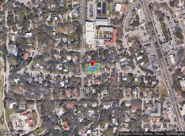
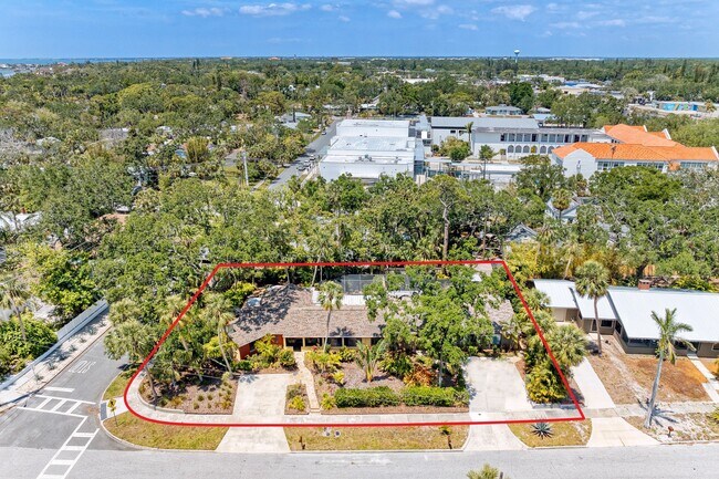
Property Record
941 Virginia Dr, Sarasota, FL 34234
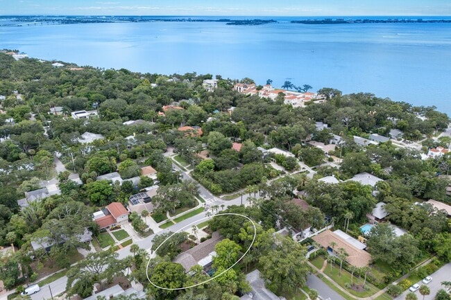
This Property Is For Sale
NEARBY LISTINGS FOR SALE OR LEASE
Property Detail
941 Virginia Dr
North Port-Sarasota-Bradenton, FL
Bay Haven
2005-15-0048
Sarasota
Triplex
Florida
X
0.37 AC
12115C0131G
North Sarasota
3,493 SF
Tampa/St Petersburg
DEMOGRAPHICS near 941 Virginia Dr
1 Mile
3 Mile
5 Mile
2024 Total Population
8,250
49,891
134,261
2029 Population
9,428
57,539
155,067
Pop Growth 2024-2029
+ 14.28%
+ 15.33%
+ 15.50%
Average Age
39
46
48
2024 Total Households
3,171
22,771
61,372
HH Growth 2024-2029
+ 14.22%
+ 15.54%
+ 15.52%
Median Household Inc
$49,311
$61,820
$68,125
Avg Household Size
2.20
2.00
2.10
2024 Avg HH Vehicles
2.00
1.00
2.00
Median Home Value
$290,922
$345,710
$345,780
Median Year Built
1965
1980
1979
Nearby Places
Map Layers
Map Styles
 Street
 Aerial
- Restaurants
- Banks
- Shops
- Fitness
- Groceries
PUBLIC TRANSPORTATION
AIRPORT
Sarasota/Bradenton International
DRIVE
WALK
Distance
Sarasota/Bradenton International
6 min
2.9 mi
Freight Ports
Port Manatee
DRIVE
WALK
Distance
Port Manatee
37 min
21.6 mi
Nearby Properties
Address
Land Use
TOTAL SIZE
Lot Size
Zoning
Address
Land Use
TOTAL SIZE
Lot Size
Zoning
1,023,770 SF
76.55 AC
Address
Land Use
TOTAL SIZE
Lot Size
Zoning
843,350 SF
5.13 AC
DTC
Address
Land Use
TOTAL SIZE
Lot Size
Zoning
124,840 SF
29.18 AC
G
Address
Land Use
TOTAL SIZE
Lot Size
Zoning
516,332 SF
7.62 AC
DTB
Address
Land Use
TOTAL SIZE
Lot Size
Zoning
390,439 SF
143.53 AC
AA
Address
Land Use
TOTAL SIZE
Lot Size
Zoning
439,798 SF
4.20 AC
DTC
Address
Land Use
TOTAL SIZE
Lot Size
Zoning
595,734 SF
1.63 AC
DTB
Address
Land Use
TOTAL SIZE
Lot Size
Zoning
595,368 SF
13.76 AC
MCI
Address
Land Use
TOTAL SIZE
Lot Size
Zoning
252,425 SF
44.30 AC
G
Address
Land Use
TOTAL SIZE
Lot Size
Zoning
458,955 SF
3.99 AC
DTE
Address
Land Use
TOTAL SIZE
Lot Size
Zoning
409,998 SF
1.09 AC
DTC
Address
Land Use
TOTAL SIZE
Lot Size
Zoning
950 SF
26.80 AC
G
Address
Land Use
TOTAL SIZE
Lot Size
Zoning
298,916 SF
36.99 AC
G
Address
Land Use
TOTAL SIZE
Lot Size
Zoning
425,298 SF
25.59 AC
PD-R
Address
Land Use
TOTAL SIZE
Lot Size
Zoning
394,304 SF
2.85 AC
DTE
Address
Land Use
TOTAL SIZE
Lot Size
Zoning
425,532 SF
3.05 AC
DTE
Address
Land Use
TOTAL SIZE
Lot Size
Zoning
331,241 SF
44.24 AC
Address
Land Use
TOTAL SIZE
Lot Size
Zoning
150,740 SF
38.70 AC
MCI
Address
Land Use
TOTAL SIZE
Lot Size
Zoning
309,573 SF
7.06 AC
ORD
Address
Land Use
TOTAL SIZE
Lot Size
Zoning
463,072 SF
2.21 AC
DTC
Address
Land Use
TOTAL SIZE
Lot Size
Zoning
1.70 AC
DTB
Address
Land Use
TOTAL SIZE
Lot Size
Zoning
223,241 SF
7.80 AC
DTE
Address
Land Use
TOTAL SIZE
Lot Size
Zoning
321,015 SF
1.11 AC
DTB
Address
Land Use
TOTAL SIZE
Lot Size
Zoning
199,653 SF
0.38 AC
DTC
Address
Land Use
TOTAL SIZE
Lot Size
Zoning
298,970 SF
38.78 AC
G
Address
Land Use
TOTAL SIZE
Lot Size
Zoning
19,464 SF
38.95 AC
G
Address
Land Use
TOTAL SIZE
Lot Size
Zoning
152,405 SF
20.44 AC
MCI
Address
Land Use
TOTAL SIZE
Lot Size
Zoning
286,339 SF
44.66 AC
G
Address
Land Use
TOTAL SIZE
Lot Size
Zoning
211,459 SF
2.36 AC
DTC
Address
Land Use
TOTAL SIZE
Lot Size
Zoning
331,816 SF
574.64 AC
The World's #1 Commercial Real Estate Marketplace
Connect with us
© 2025 CoStar Group
The information above has been obtained from sources believed reliable. While we do not doubt its accuracy we have not verified it and make no guarantee, warranty or representation about it. It is your responsibility to independently confirm its accuracy and completeness. Any projections, opinions, assumptions, or estimates used are for example only and do not represent the current or future performance of the property. The value of this transaction to you depends on tax and other factors which should be evaluated by your tax, financial, and legal advisors. You and your advisors should conduct a careful, independent investigation of the property to determine to your satisfaction the suitability of the property for your needs.