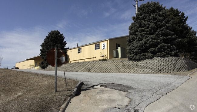
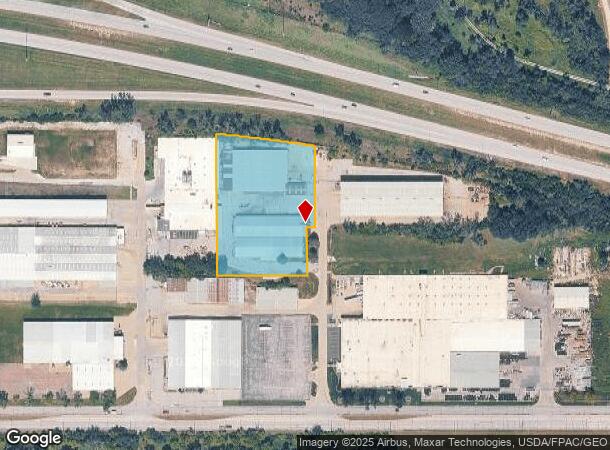
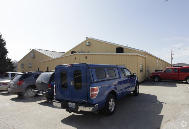
Property Record
9410 N 44Th St, Omaha, NE 68112
NEARBY LISTINGS FOR SALE OR LEASE
Property Detail
9410 N 44Th St
Omaha, NE-IA
Mckinley Heights 2
3011-0208-17
MCKINLEY HEIGHTS 2 LOT 5 BLOCK 0 IRREG 2.582 AC
Lightindustrial
Douglas
X
Nebraska
31055C0226H
5
2024
2.58 AC
2025
Northeast Omaha
007304
Omaha/Council Bluffs
48,060 SF
DEMOGRAPHICS near 9410 N 44Th St
1 Mile
3 Mile
5 Mile
2024 Total Population
2,467
35,126
108,262
2029 Population
2,549
35,747
110,336
Pop Growth 2024-2029
+ 3.32%
+ 1.77%
+ 1.92%
Average Age
47
39
37
2024 Total Households
1,099
13,077
40,452
HH Growth 2024-2029
+ 3.46%
+ 1.77%
+ 1.94%
Median Household Inc
$65,030
$45,719
$51,426
Avg Household Size
2.20
2.60
2.60
2024 Avg HH Vehicles
2.00
2.00
2.00
Median Home Value
$240,449
$149,424
$156,246
Median Year Built
1969
1961
1960
Nearby Places
Map Layers
Map Styles
 Street
 Aerial
- Restaurants
- Banks
- Shops
- Fitness
- Groceries
PUBLIC TRANSPORTATION
COMMUTER RAIL
Omaha Amtrak Station (California Zephyr - Amtrak)
DRIVE
WALK
Distance
Omaha Amtrak Station (California Zephyr - Amtrak)
16 min
8.6 mi
Omaha Amtrak Station (California Zephyr - Amtrak)
DRIVE
WALK
Distance
Omaha Amtrak Station (California Zephyr - Amtrak)
17 min
8.8 mi
AIRPORT
Eppley Airfield
DRIVE
WALK
Distance
Eppley Airfield
16 min
7.2 mi
Freight Ports
Tulsa Port Of Catoosa
DRIVE
WALK
Distance
Tulsa Port Of Catoosa
473 min
424.9 mi
Nearby Properties
Address
Land Use
TOTAL SIZE
Lot Size
Zoning
Address
Land Use
TOTAL SIZE
Lot Size
Zoning
141,816 SF
24.91 AC
Address
Land Use
TOTAL SIZE
Lot Size
Zoning
125,945 SF
Address
Land Use
TOTAL SIZE
Lot Size
Zoning
172,424 SF
2.88 AC
R7
Address
Land Use
TOTAL SIZE
Lot Size
Zoning
164,320 SF
6.88 AC
Address
Land Use
TOTAL SIZE
Lot Size
Zoning
92,817 SF
5.68 AC
GO
Address
Land Use
TOTAL SIZE
Lot Size
Zoning
61,867 SF
8.46 AC
MU
Address
Land Use
TOTAL SIZE
Lot Size
Zoning
111,770 SF
2.65 AC
Address
Land Use
TOTAL SIZE
Lot Size
Zoning
74,015 SF
27.11 AC
DR
Address
Land Use
TOTAL SIZE
Lot Size
Zoning
51,129 SF
10.18 AC
DR
Address
Land Use
TOTAL SIZE
Lot Size
Zoning
801,643 SF
1.72 AC
Address
Land Use
TOTAL SIZE
Lot Size
Zoning
246,595 SF
17.53 AC
HI
Address
Land Use
TOTAL SIZE
Lot Size
Zoning
97,368 SF
5.51 AC
GI
Address
Land Use
TOTAL SIZE
Lot Size
Zoning
92,214 SF
4.67 AC
GI
Address
Land Use
TOTAL SIZE
Lot Size
Zoning
28,084 SF
5.22 AC
Address
Land Use
TOTAL SIZE
Lot Size
Zoning
73,976 SF
6.80 AC
Address
Land Use
TOTAL SIZE
Lot Size
Zoning
74,920 SF
4.53 AC
Address
Land Use
TOTAL SIZE
Lot Size
Zoning
115,137 SF
7.45 AC
R6
Address
Land Use
TOTAL SIZE
Lot Size
Zoning
61,500 SF
6.84 AC
MU
Address
Land Use
TOTAL SIZE
Lot Size
Zoning
77,976 SF
4 AC
R6
Address
Land Use
TOTAL SIZE
Lot Size
Zoning
167,580 SF
10.63 AC
GI
Address
Land Use
TOTAL SIZE
Lot Size
Zoning
44,545 SF
4.40 AC
R7
Address
Land Use
TOTAL SIZE
Lot Size
Zoning
130,933 SF
3.02 AC
Address
Land Use
TOTAL SIZE
Lot Size
Zoning
41,717 SF
5.25 AC
CC
Address
Land Use
TOTAL SIZE
Lot Size
Zoning
54,041 SF
4.44 AC
Address
Land Use
TOTAL SIZE
Lot Size
Zoning
84,698 SF
7.01 AC
Address
Land Use
TOTAL SIZE
Lot Size
Zoning
37,120 SF
2.74 AC
CC
Address
Land Use
TOTAL SIZE
Lot Size
Zoning
131,150 SF
3.28 AC
GI
Address
Land Use
TOTAL SIZE
Lot Size
Zoning
17,798 SF
1.78 AC
NBD
Address
Land Use
TOTAL SIZE
Lot Size
Zoning
68,709 SF
3.57 AC
GI
Address
Land Use
TOTAL SIZE
Lot Size
Zoning
59,120 SF
7.32 AC
The World's #1 Commercial Real Estate Marketplace
Connect with us
© 2026 CoStar Group
The information above has been obtained from sources believed reliable. While we do not doubt its accuracy we have not verified it and make no guarantee, warranty or representation about it. It is your responsibility to independently confirm its accuracy and completeness. Any projections, opinions, assumptions, or estimates used are for example only and do not represent the current or future performance of the property. The value of this transaction to you depends on tax and other factors which should be evaluated by your tax, financial, and legal advisors. You and your advisors should conduct a careful, independent investigation of the property to determine to your satisfaction the suitability of the property for your needs.