Property Record
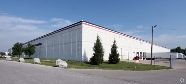
9420 E 33Rd St, Indianapolis, IN 46235


Property Detail
9420 E 33Rd St
49-08-20-107-022.000-700
PT S1/2 S20 T16 R5 BEG 1996.87 E OF NW COR E1242.75 S 605.8 SW 44.82 W 230 S 30 W 158.48 SWRLY210.98 SWRLY 210.98 W 408 WRLY 33.56 NE 787.35 TOBEG 20.786 AC
Warehouse
Marion
C and X Area of minimal flood hazard, usually depicted on FIRMs as above the 500-year flood level.
Indiana
2024
20.88 AC
2025
Washington Square
360402
Indianapolis
329,180 SF
Indianapolis-Carmel-Greenwood, IN
NEARBY LISTINGS FOR SALE OR LEASE
DEMOGRAPHICS near 9420 E 33Rd St
1 mile
3 mile
5 mile
2025 Total Population
13,662
90,422
179,160
2030 Population
13,785
91,098
181,605
Pop Growth 2025-2030
+ 0.90%
+ 0.75%
+ 1.36%
Average Age
34
35
37
2025 Total Households
5,040
34,205
69,769
HH Growth 2025-2030
+ 0.89%
+ 0.72%
+ 1.39%
Median Household Inc
$45,077
$54,149
$60,648
Avg Household Size
2.60
2.60
2.50
2025 Avg HH Vehicles
1.00
2.00
2.00
Median Home Value
$144,027
$170,146
$203,403
Median Year Built
1968
1973
1971
Nearby Places
Map Layers
Map Styles
 Street
 Aerial
Layers
 Traffic
 Biking
Places
Listings with unknown addresses are not visible on the map
- Restaurants
- Banks
- Shops
- Fitness
- Groceries
PUBLIC TRANSPORTATION
AIRPORT
Indianapolis International
Drive
Walk
Distance
Indianapolis International
42 min
24.8 mi
Nearby Properties
Address
Land Use
TOTAL SIZE
Lot Size
Zoning
Address
Land Use
TOTAL SIZE
Lot Size
Zoning
11,154 SF
21.99 AC
Address
Land Use
TOTAL SIZE
Lot Size
Zoning
532,932 SF
61.88 AC
ZO03
Address
Land Use
TOTAL SIZE
Lot Size
Zoning
4,217 SF
7.37 AC
ZO01
Address
Land Use
TOTAL SIZE
Lot Size
Zoning
679,214 SF
16.70 AC
ZO01
Address
Land Use
TOTAL SIZE
Lot Size
Zoning
2,556 SF
35.56 AC
ZO01
Address
Land Use
TOTAL SIZE
Lot Size
Zoning
4,588 SF
24.33 AC
ZO01
Address
Land Use
TOTAL SIZE
Lot Size
Zoning
4,379 SF
11.48 AC
ZO01
Address
Land Use
TOTAL SIZE
Lot Size
Zoning
7,284 SF
17.31 AC
Address
Land Use
TOTAL SIZE
Lot Size
Zoning
136,336 SF
8.74 AC
ZO01
Address
Land Use
TOTAL SIZE
Lot Size
Zoning
6,000 SF
8.79 AC
ZO01
Address
Land Use
TOTAL SIZE
Lot Size
Zoning
5,560 SF
10.88 AC
ZO01
Address
Land Use
TOTAL SIZE
Lot Size
Zoning
536,804 SF
25.94 AC
ZO01
Address
Land Use
TOTAL SIZE
Lot Size
Zoning
65,095 SF
4.06 AC
ZO01
Address
Land Use
TOTAL SIZE
Lot Size
Zoning
118,126 SF
6.31 AC
ZO01
Address
Land Use
TOTAL SIZE
Lot Size
Zoning
170,000 SF
11.29 AC
ZO01
Address
Land Use
TOTAL SIZE
Lot Size
Zoning
150,929 SF
28.61 AC
ZO01
Address
Land Use
TOTAL SIZE
Lot Size
Zoning
268,930 SF
20.55 AC
ZO01
Address
Land Use
TOTAL SIZE
Lot Size
Zoning
925,384 SF
49.48 AC
ZO01
Address
Land Use
TOTAL SIZE
Lot Size
Zoning
167,808 SF
14.95 AC
ZO01
Address
Land Use
TOTAL SIZE
Lot Size
Zoning
5,620 SF
36.95 AC
ZO01
Address
Land Use
TOTAL SIZE
Lot Size
Zoning
1,768 SF
30.88 AC
ZO01
Address
Land Use
TOTAL SIZE
Lot Size
Zoning
5,512 SF
19.05 AC
ZO01
Address
Land Use
TOTAL SIZE
Lot Size
Zoning
269,450 SF
5.85 AC
Address
Land Use
TOTAL SIZE
Lot Size
Zoning
1,865 SF
22.15 AC
ZO01
Address
Land Use
TOTAL SIZE
Lot Size
Zoning
1,490 SF
14.21 AC
ZO01
Address
Land Use
TOTAL SIZE
Lot Size
Zoning
206,080 SF
12.97 AC
ZO01
Address
Land Use
TOTAL SIZE
Lot Size
Zoning
128,126 SF
12.99 AC
ZO01
Address
Land Use
TOTAL SIZE
Lot Size
Zoning
4,878 SF
25.65 AC
Address
Land Use
TOTAL SIZE
Lot Size
Zoning
1,594 SF
6.47 AC
ZO01
The World's #1 Commercial Real Estate Marketplace
Connect with us
© 2026 CoStar Group
The information above has been obtained from sources believed reliable. While we do not doubt its accuracy we have not verified it and make no guarantee, warranty or representation about it. It is your responsibility to independently confirm its accuracy and completeness. Any projections, opinions, assumptions, or estimates used are for example only and do not represent the current or future performance of the property. The value of this transaction to you depends on tax and other factors which should be evaluated by your tax, financial, and legal advisors. You and your advisors should conduct a careful, independent investigation of the property to determine to your satisfaction the suitability of the property for your needs.