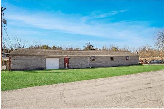
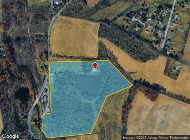
Property Record
968 Bangor Rd, Nazareth, PA 18064
NEARBY LISTINGS FOR SALE OR LEASE
Property Detail
968 Bangor Rd
G8-18-8-0626
Northampton
Agriculturalnec
Pennsylvania
AE
40.35 AC
42095C0142E
Lehigh Valley
2025
Philadelphia
2025
Allentown-Bethlehem-Easton, PA-NJ
016802
DEMOGRAPHICS near 968 Bangor Rd
1 Mile
3 Mile
5 Mile
2024 Total Population
901
7,418
38,676
2029 Population
884
7,419
38,824
Pop Growth 2024-2029
(1.89%)
+ 0.01%
+ 0.38%
Average Age
46
45
44
2024 Total Households
360
2,826
15,378
HH Growth 2024-2029
(1.67%)
+ 0.04%
+ 0.41%
Median Household Inc
$88,871
$90,295
$86,140
Avg Household Size
2.40
2.60
2.50
2024 Avg HH Vehicles
3.00
2.00
2.00
Median Home Value
$269,444
$305,739
$289,432
Median Year Built
1969
1978
1976
Nearby Places
Map Layers
Map Styles
 Street
 Aerial
- Restaurants
- Banks
- Shops
- Fitness
- Groceries
PUBLIC TRANSPORTATION
AIRPORT
Lehigh Valley International
DRIVE
WALK
Distance
Lehigh Valley International
28 min
17.9 mi
Freight Ports
Port of Philadelphia
DRIVE
WALK
Distance
Port of Philadelphia
107 min
67.8 mi
SALE & LEASE HISTORY
LISTING DATE
SALE/LEASE

Apr 08, 2021
For Sale
Nearby Properties
Address
Land Use
TOTAL SIZE
Lot Size
Zoning
Address
Land Use
TOTAL SIZE
Lot Size
Zoning
93,785 SF
76.54 AC
RR
Address
Land Use
TOTAL SIZE
Lot Size
Zoning
130,433 SF
31 AC
RR
Address
Land Use
TOTAL SIZE
Lot Size
Zoning
193,460 SF
18.26 AC
IBP
Address
Land Use
TOTAL SIZE
Lot Size
Zoning
29,666 SF
11.17 AC
FF
Address
Land Use
TOTAL SIZE
Lot Size
Zoning
15,100 SF
13.54 AC
MS
Address
Land Use
TOTAL SIZE
Lot Size
Zoning
21,655 SF
4.49 AC
IP
Address
Land Use
TOTAL SIZE
Lot Size
Zoning
48,084 SF
7.96 AC
RA
Address
Land Use
TOTAL SIZE
Lot Size
Zoning
1,050 SF
4.48 AC
PR
Address
Land Use
TOTAL SIZE
Lot Size
Zoning
5,106 SF
60.79 AC
RA
Address
Land Use
TOTAL SIZE
Lot Size
Zoning
18,710 SF
26.90 AC
GC
Address
Land Use
TOTAL SIZE
Lot Size
Zoning
53,467 SF
4.10 AC
IP
Address
Land Use
TOTAL SIZE
Lot Size
Zoning
13.85 AC
R1
Address
Land Use
TOTAL SIZE
Lot Size
Zoning
58,902 SF
11.29 AC
1P
Address
Land Use
TOTAL SIZE
Lot Size
Zoning
298.49 AC
RC
Address
Land Use
TOTAL SIZE
Lot Size
Zoning
21,600 SF
11.74 AC
GC
Address
Land Use
TOTAL SIZE
Lot Size
Zoning
8,502 SF
6.34 AC
GC
Address
Land Use
TOTAL SIZE
Lot Size
Zoning
9,960 SF
30.20 AC
RC
Address
Land Use
TOTAL SIZE
Lot Size
Zoning
43,192 SF
2.82 AC
IP
Address
Land Use
TOTAL SIZE
Lot Size
Zoning
29,523 SF
4.68 AC
EE
Address
Land Use
TOTAL SIZE
Lot Size
Zoning
4,200 SF
6 AC
GC
Address
Land Use
TOTAL SIZE
Lot Size
Zoning
2,400 SF
5.41 AC
IP
Address
Land Use
TOTAL SIZE
Lot Size
Zoning
8,069 SF
7.33 AC
HI
Address
Land Use
TOTAL SIZE
Lot Size
Zoning
1,056 SF
147.23 AC
RC
Address
Land Use
TOTAL SIZE
Lot Size
Zoning
29,680 SF
3.05 AC
VC
Address
Land Use
TOTAL SIZE
Lot Size
Zoning
4,200 SF
73.54 AC
FF
Address
Land Use
TOTAL SIZE
Lot Size
Zoning
9,800 SF
3.27 AC
IBP
Address
Land Use
TOTAL SIZE
Lot Size
Zoning
3,655 SF
5.29 AC
RR
Address
Land Use
TOTAL SIZE
Lot Size
Zoning
7,080 SF
11 AC
SR
Address
Land Use
TOTAL SIZE
Lot Size
Zoning
7,308 SF
10.48 AC
GC
Address
Land Use
TOTAL SIZE
Lot Size
Zoning
16,316 SF
2.74 AC
GI
The World's #1 Commercial Real Estate Marketplace
Connect with us
© 2025 CoStar Group
The information above has been obtained from sources believed reliable. While we do not doubt its accuracy we have not verified it and make no guarantee, warranty or representation about it. It is your responsibility to independently confirm its accuracy and completeness. Any projections, opinions, assumptions, or estimates used are for example only and do not represent the current or future performance of the property. The value of this transaction to you depends on tax and other factors which should be evaluated by your tax, financial, and legal advisors. You and your advisors should conduct a careful, independent investigation of the property to determine to your satisfaction the suitability of the property for your needs.