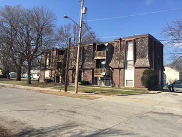
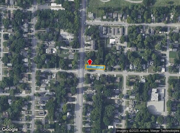
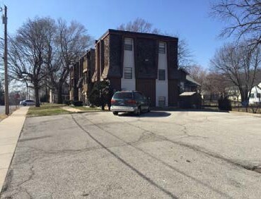
Property Record
943 S Noland Rd, Independence, MO 64050
NEARBY LISTINGS FOR SALE OR LEASE
-
-
View all Independence listings for sale on LoopNet.com
Property Detail
943 S Noland Rd
Kansas City, MO-KS
Clarendon Place
26-510-13-12-00-0-00-000
CLARENDON PLACE LOT 8 BLK 3
Apartment
Jackson
X
Missouri
29095C0283G
8
2024
0.22 AC
2025
Benton
011501
Kansas City
3,640 SF
DEMOGRAPHICS near 943 S Noland Rd
1 Mile
3 Mile
5 Mile
2024 Total Population
9,269
78,258
141,013
2029 Population
9,250
77,599
139,905
Pop Growth 2024-2029
(0.20%)
(0.84%)
(0.79%)
Average Age
40
41
41
2024 Total Households
3,964
32,661
58,210
HH Growth 2024-2029
(0.33%)
(1.01%)
(0.92%)
Median Household Inc
$39,681
$53,778
$57,188
Avg Household Size
2.20
2.30
2.30
2024 Avg HH Vehicles
2.00
2.00
2.00
Median Home Value
$126,576
$147,641
$156,222
Median Year Built
1952
1962
1967
Nearby Places
Map Layers
Map Styles
 Street
 Aerial
- Restaurants
- Banks
- Shops
- Fitness
- Groceries
PUBLIC TRANSPORTATION
COMMUTER RAIL
DRIVE
WALK
Distance
3 min
1.3 mi
AIRPORT
Kansas City International
DRIVE
WALK
Distance
Kansas City International
43 min
31.6 mi
Nearby Properties
Address
Land Use
TOTAL SIZE
Lot Size
Zoning
Address
Land Use
TOTAL SIZE
Lot Size
Zoning
519,315 SF
28.47 AC
Address
Land Use
TOTAL SIZE
Lot Size
Zoning
250,196 SF
39.50 AC
Address
Land Use
TOTAL SIZE
Lot Size
Zoning
455,100 SF
42.02 AC
Address
Land Use
TOTAL SIZE
Lot Size
Zoning
123,305 SF
15.51 AC
Address
Land Use
TOTAL SIZE
Lot Size
Zoning
64,318 SF
32.40 AC
Address
Land Use
TOTAL SIZE
Lot Size
Zoning
213,615 SF
15.50 AC
Address
Land Use
TOTAL SIZE
Lot Size
Zoning
74,801 SF
8.93 AC
Address
Land Use
TOTAL SIZE
Lot Size
Zoning
210,008 SF
16.89 AC
Address
Land Use
TOTAL SIZE
Lot Size
Zoning
157,666 SF
18.54 AC
Address
Land Use
TOTAL SIZE
Lot Size
Zoning
139,713 SF
15.70 AC
Address
Land Use
TOTAL SIZE
Lot Size
Zoning
157,429 SF
36.60 AC
Address
Land Use
TOTAL SIZE
Lot Size
Zoning
111,445 SF
8 AC
Address
Land Use
TOTAL SIZE
Lot Size
Zoning
48,664 SF
8.44 AC
Address
Land Use
TOTAL SIZE
Lot Size
Zoning
71,339 SF
0.68 AC
Address
Land Use
TOTAL SIZE
Lot Size
Zoning
113,667 SF
6.31 AC
Address
Land Use
TOTAL SIZE
Lot Size
Zoning
190,810 SF
26.90 AC
Address
Land Use
TOTAL SIZE
Lot Size
Zoning
55,985 SF
20.93 AC
Address
Land Use
TOTAL SIZE
Lot Size
Zoning
23,925 SF
19.96 AC
Address
Land Use
TOTAL SIZE
Lot Size
Zoning
36,883 SF
14.60 AC
Address
Land Use
TOTAL SIZE
Lot Size
Zoning
45,832 SF
8.61 AC
Address
Land Use
TOTAL SIZE
Lot Size
Zoning
286,490 SF
37.30 AC
Address
Land Use
TOTAL SIZE
Lot Size
Zoning
66,168 SF
44.98 AC
Address
Land Use
TOTAL SIZE
Lot Size
Zoning
45,870 SF
2.01 AC
Address
Land Use
TOTAL SIZE
Lot Size
Zoning
104,740 SF
7.25 AC
Address
Land Use
TOTAL SIZE
Lot Size
Zoning
114,248 SF
5.02 AC
Address
Land Use
TOTAL SIZE
Lot Size
Zoning
111,120 SF
12.61 AC
Address
Land Use
TOTAL SIZE
Lot Size
Zoning
153,774 SF
Address
Land Use
TOTAL SIZE
Lot Size
Zoning
39,120 SF
1.87 AC
Address
Land Use
TOTAL SIZE
Lot Size
Zoning
101,268 SF
13.09 AC
Address
Land Use
TOTAL SIZE
Lot Size
Zoning
48,330 SF
12.31 AC
The World's #1 Commercial Real Estate Marketplace
Connect with us
© 2025 CoStar Group
The information above has been obtained from sources believed reliable. While we do not doubt its accuracy we have not verified it and make no guarantee, warranty or representation about it. It is your responsibility to independently confirm its accuracy and completeness. Any projections, opinions, assumptions, or estimates used are for example only and do not represent the current or future performance of the property. The value of this transaction to you depends on tax and other factors which should be evaluated by your tax, financial, and legal advisors. You and your advisors should conduct a careful, independent investigation of the property to determine to your satisfaction the suitability of the property for your needs.