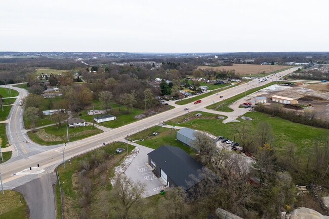
Property Record
943 State Road 25 Way W, Lafayette, IN 47909
NEARBY LISTINGS FOR SALE OR LEASE
-
-
View all Lafayette listings for lease on LoopNet.com
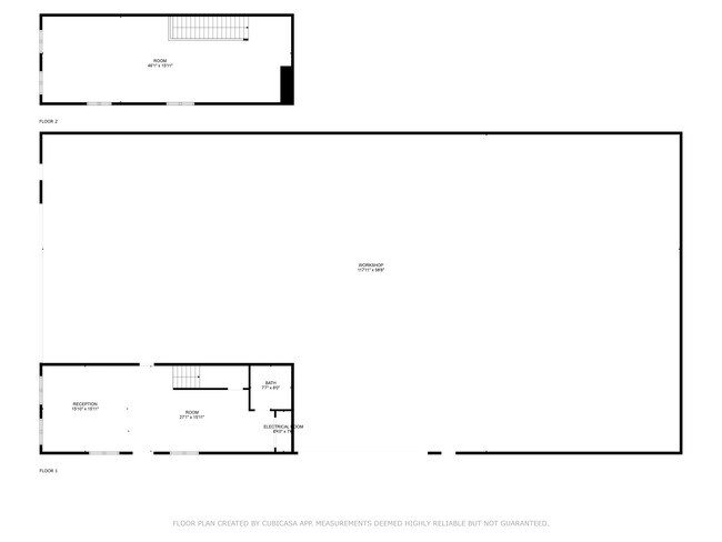
Property Detail
943 State Road 25 Way W
79-11-06-101-004.000-033
PT W NW SEC 6 TWP 22 R4 .206 A90 X 100 FT
Warehouse
Tippecanoe
X
Indiana
18157C0143E
1
2024
0.52 AC
2024
Lafayette/Kokomo
001501
Other Market Areas
7,952 SF
Lafayette-West Lafayette, IN
DEMOGRAPHICS near 943 State Road 25 Way W
1 Mile
3 Mile
5 Mile
2024 Total Population
4,653
51,136
117,740
2029 Population
4,919
53,729
123,448
Pop Growth 2024-2029
+ 5.72%
+ 5.07%
+ 4.85%
Average Age
34
34
34
2024 Total Households
2,082
21,004
47,099
HH Growth 2024-2029
+ 6.10%
+ 5.66%
+ 5.48%
Median Household Inc
$40,560
$45,865
$45,744
Avg Household Size
2.20
2.20
2.20
2024 Avg HH Vehicles
2.00
2.00
2.00
Median Home Value
$156,225
$158,427
$170,311
Median Year Built
1994
1984
1981
Nearby Places
Map Layers
Map Styles
 Street
 Aerial
- Restaurants
- Banks
- Shops
- Fitness
- Groceries
PUBLIC TRANSPORTATION
COMMUTER RAIL
Lafayette Amtrak Station (Cardinal - Amtrak)
DRIVE
WALK
Distance
Lafayette Amtrak Station (Cardinal - Amtrak)
6 min
3.5 mi
Freight Ports
Port Milwaukee
DRIVE
WALK
Distance
Port Milwaukee
256 min
210.9 mi
SALE & LEASE HISTORY
LISTING DATE
SALE/LEASE

Apr 19, 2025
For Lease
Nearby Properties
Address
Land Use
TOTAL SIZE
Lot Size
Zoning
Address
Land Use
TOTAL SIZE
Lot Size
Zoning
469,872 SF
0.85 AC
Address
Land Use
TOTAL SIZE
Lot Size
Zoning
377,937 SF
4.80 AC
Address
Land Use
TOTAL SIZE
Lot Size
Zoning
385,162 SF
1 AC
Address
Land Use
TOTAL SIZE
Lot Size
Zoning
401,345 SF
1.64 AC
Address
Land Use
TOTAL SIZE
Lot Size
Zoning
417,720 SF
3.09 AC
Address
Land Use
TOTAL SIZE
Lot Size
Zoning
249,214 SF
1.93 AC
Address
Land Use
TOTAL SIZE
Lot Size
Zoning
159,723 SF
4.87 AC
Address
Land Use
TOTAL SIZE
Lot Size
Zoning
148,860 SF
1.25 AC
Address
Land Use
TOTAL SIZE
Lot Size
Zoning
232,565 SF
1.15 AC
Address
Land Use
TOTAL SIZE
Lot Size
Zoning
8,675 SF
0.02 AC
Address
Land Use
TOTAL SIZE
Lot Size
Zoning
205,701 SF
1.27 AC
Address
Land Use
TOTAL SIZE
Lot Size
Zoning
164,234 SF
0.88 AC
Address
Land Use
TOTAL SIZE
Lot Size
Zoning
184,441 SF
44 SF
Address
Land Use
TOTAL SIZE
Lot Size
Zoning
222,276 SF
0.31 AC
Address
Land Use
TOTAL SIZE
Lot Size
Zoning
203,830 SF
18.73 AC
Address
Land Use
TOTAL SIZE
Lot Size
Zoning
267,379 SF
87 SF
Address
Land Use
TOTAL SIZE
Lot Size
Zoning
113,044 SF
44 SF
Address
Land Use
TOTAL SIZE
Lot Size
Zoning
118,066 SF
0.80 AC
Address
Land Use
TOTAL SIZE
Lot Size
Zoning
135,090 SF
0.80 AC
Address
Land Use
TOTAL SIZE
Lot Size
Zoning
286,889 SF
17.89 AC
Address
Land Use
TOTAL SIZE
Lot Size
Zoning
109,515 SF
0.85 AC
Address
Land Use
TOTAL SIZE
Lot Size
Zoning
72,739 SF
1.46 AC
Address
Land Use
TOTAL SIZE
Lot Size
Zoning
109,876 SF
0.61 AC
Address
Land Use
TOTAL SIZE
Lot Size
Zoning
245,034 SF
1.39 AC
Address
Land Use
TOTAL SIZE
Lot Size
Zoning
61,215 SF
0.39 AC
Address
Land Use
TOTAL SIZE
Lot Size
Zoning
81,265 SF
0.74 AC
Address
Land Use
TOTAL SIZE
Lot Size
Zoning
48,045 SF
1.15 AC
Address
Land Use
TOTAL SIZE
Lot Size
Zoning
153,190 SF
Address
Land Use
TOTAL SIZE
Lot Size
Zoning
59,892 SF
1.20 AC
The World's #1 Commercial Real Estate Marketplace
Connect with us
© 2026 CoStar Group
The information above has been obtained from sources believed reliable. While we do not doubt its accuracy we have not verified it and make no guarantee, warranty or representation about it. It is your responsibility to independently confirm its accuracy and completeness. Any projections, opinions, assumptions, or estimates used are for example only and do not represent the current or future performance of the property. The value of this transaction to you depends on tax and other factors which should be evaluated by your tax, financial, and legal advisors. You and your advisors should conduct a careful, independent investigation of the property to determine to your satisfaction the suitability of the property for your needs.