Property Record
9435 E Cherry Bend Rd, Traverse City, MI 49684

Save to a Folder
{{folder.Name}}
{{folder.ListingIds.length}} Properties
{{folder.ListingIds.length}} Property
Create a New Folder
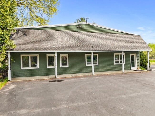
This Property Is For Sale
Property Detail
9435 E Cherry Bend Rd
Traverse City, MI
L388 P698 L468 P659 L483 P298 L502 P558 L534 P930 L675 P799&802&821 L909 P346/06 PRT OF GOVT LOT 1 S
004-020-001-10
Leelanau
Commercialnec
Michigan
B and X Area of moderate flood hazard, usually the area between the limits of the 100-year and 500-year floods.
1
2025
0.56 AC
2026
Michigan Northwest Area
970602
Other Market Areas
5,000 SF
NEARBY LISTINGS FOR SALE OR LEASE
-
-
View all Traverse City listings for sale on LoopNet.com
DEMOGRAPHICS near 9435 E Cherry Bend Rd
1 mile
3 mile
5 mile
2025 Total Population
439
4,526
21,898
2030 Population
431
4,461
21,852
Pop Growth 2025-2030
(1.82%)
(1.44%)
(0.21%)
Average Age
50
46
46
2025 Total Households
190
1,931
9,716
HH Growth 2025-2030
(2.11%)
(1.66%)
(0.16%)
Median Household Inc
$131,771
$96,220
$90,854
Avg Household Size
2.30
2.30
2.20
2025 Avg HH Vehicles
2.00
2.00
2.00
Median Home Value
$471,874
$414,901
$442,592
Median Year Built
1984
1984
1977
Nearby Places
Map Layers
Map Styles
 Street
 Aerial
Layers
 Traffic
 Biking
Places
Listings with unknown addresses are not visible on the map
- Restaurants
- Banks
- Shops
- Fitness
- Groceries
PUBLIC TRANSPORTATION
AIRPORT
Cherry Capital
Drive
Walk
Distance
Cherry Capital
22 min
8.7 mi
Freight Ports
Port Milwaukee
Drive
Walk
Distance
Port Milwaukee
474 min
408.5 mi
Nearby Properties
Address
Land Use
TOTAL SIZE
Lot Size
Zoning
Address
Land Use
TOTAL SIZE
Lot Size
Zoning
13.13 AC
Address
Land Use
TOTAL SIZE
Lot Size
Zoning
61,216 SF
3.10 AC
Address
Land Use
TOTAL SIZE
Lot Size
Zoning
50,729 SF
6.91 AC
Address
Land Use
TOTAL SIZE
Lot Size
Zoning
64,566 SF
3.42 AC
GTRW
Address
Land Use
TOTAL SIZE
Lot Size
Zoning
Address
Land Use
TOTAL SIZE
Lot Size
Zoning
23,792 SF
4.05 AC
GTRW
Address
Land Use
TOTAL SIZE
Lot Size
Zoning
30,559 SF
2.45 AC
Address
Land Use
TOTAL SIZE
Lot Size
Zoning
28,835 SF
3.60 AC
Address
Land Use
TOTAL SIZE
Lot Size
Zoning
1,068 SF
3 AC
Address
Land Use
TOTAL SIZE
Lot Size
Zoning
1,491 SF
9.15 AC
Address
Land Use
TOTAL SIZE
Lot Size
Zoning
11,780 SF
2.17 AC
Address
Land Use
TOTAL SIZE
Lot Size
Zoning
1,566 SF
4.34 AC
Address
Land Use
TOTAL SIZE
Lot Size
Zoning
12,488 SF
0.81 AC
GTRW
Address
Land Use
TOTAL SIZE
Lot Size
Zoning
6,319 SF
0.69 AC
GTRW
Address
Land Use
TOTAL SIZE
Lot Size
Zoning
6,944 SF
1.33 AC
Address
Land Use
TOTAL SIZE
Lot Size
Zoning
Address
Land Use
TOTAL SIZE
Lot Size
Zoning
0.68 AC
GTRW
Address
Land Use
TOTAL SIZE
Lot Size
Zoning
Address
Land Use
TOTAL SIZE
Lot Size
Zoning
4,196 SF
30 AC
Address
Land Use
TOTAL SIZE
Lot Size
Zoning
Address
Land Use
TOTAL SIZE
Lot Size
Zoning
Address
Land Use
TOTAL SIZE
Lot Size
Zoning
6,261 SF
0.90 AC
GTRW
Address
Land Use
TOTAL SIZE
Lot Size
Zoning
5,500 SF
2.31 AC
Address
Land Use
TOTAL SIZE
Lot Size
Zoning
12,867 SF
11 AC
Address
Land Use
TOTAL SIZE
Lot Size
Zoning
Address
Land Use
TOTAL SIZE
Lot Size
Zoning
4,480 SF
8.97 AC
Address
Land Use
TOTAL SIZE
Lot Size
Zoning
28,835 SF
6.81 AC
Address
Land Use
TOTAL SIZE
Lot Size
Zoning
3,407 SF
130 AC
Address
Land Use
TOTAL SIZE
Lot Size
Zoning
10.55 AC
GTRW
Address
Land Use
TOTAL SIZE
Lot Size
Zoning
6,094 SF
1.04 AC
The World's #1 Commercial Real Estate Marketplace
Connect with us
© 2026 CoStar Group
The information above has been obtained from sources believed reliable. While we do not doubt its accuracy we have not verified it and make no guarantee, warranty or representation about it. It is your responsibility to independently confirm its accuracy and completeness. Any projections, opinions, assumptions, or estimates used are for example only and do not represent the current or future performance of the property. The value of this transaction to you depends on tax and other factors which should be evaluated by your tax, financial, and legal advisors. You and your advisors should conduct a careful, independent investigation of the property to determine to your satisfaction the suitability of the property for your needs.