Property Record
944 Raymond, Port Bolivar, TX 77650
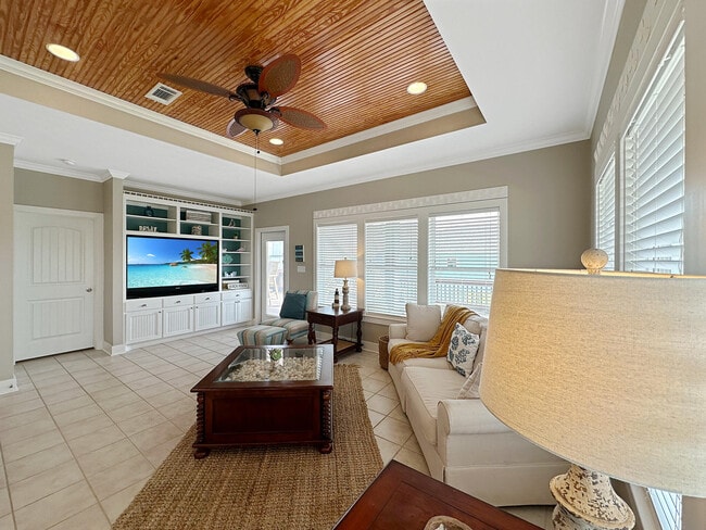
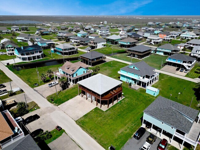
This Property Is For Sale
NEARBY LISTINGS FOR SALE OR LEASE
-
-
View all Port Bolivar listings for sale on LoopNet.com
Property Detail
944 Raymond
Houston-Pasadena-The Woodlands, TX
Sandy Shores
6285-0000-0077-000
ABST 65 B FRANKS SUR LOT 76 SANDY SHORES
Sfr
Galveston
VE
Texas
48167C0328G
76
2024
0.16 AC
2025
Outlying Chambers County
7239002068
Houston
1,296 SF
DEMOGRAPHICS near 944 Raymond
1 Mile
3 Mile
5 Mile
2024 Total Population
309
854
1,222
2029 Population
300
829
1,188
Pop Growth 2024-2029
(2.91%)
(2.93%)
(2.78%)
Average Age
57
57
56
2024 Total Households
163
449
648
HH Growth 2024-2029
(3.07%)
(2.67%)
(2.62%)
Median Household Inc
$67,500
$66,875
$65,376
Avg Household Size
1.90
1.90
1.90
2024 Avg HH Vehicles
2.00
2.00
2.00
Median Home Value
$410,169
$410,061
$410,330
Median Year Built
2004
2004
2004
Nearby Places
Map Layers
Map Styles
 Street
 Aerial
- Restaurants
- Banks
- Shops
- Fitness
- Groceries
Nearby Properties
Address
Land Use
TOTAL SIZE
Lot Size
Zoning
Address
Land Use
TOTAL SIZE
Lot Size
Zoning
36,085 SF
5.73 AC
Address
Land Use
TOTAL SIZE
Lot Size
Zoning
8,208 SF
0.12 AC
Address
Land Use
TOTAL SIZE
Lot Size
Zoning
52,600 SF
1.94 AC
Address
Land Use
TOTAL SIZE
Lot Size
Zoning
31,360 SF
5 AC
Address
Land Use
TOTAL SIZE
Lot Size
Zoning
11,250 SF
2.89 AC
Address
Land Use
TOTAL SIZE
Lot Size
Zoning
2,532 SF
40 AC
Address
Land Use
TOTAL SIZE
Lot Size
Zoning
11,400 SF
2.46 AC
Address
Land Use
TOTAL SIZE
Lot Size
Zoning
6,648 SF
0.79 AC
Address
Land Use
TOTAL SIZE
Lot Size
Zoning
80.72 AC
Address
Land Use
TOTAL SIZE
Lot Size
Zoning
Address
Land Use
TOTAL SIZE
Lot Size
Zoning
10,388 SF
2.50 AC
Address
Land Use
TOTAL SIZE
Lot Size
Zoning
0.71 AC
Address
Land Use
TOTAL SIZE
Lot Size
Zoning
7,484 SF
9.90 AC
Address
Land Use
TOTAL SIZE
Lot Size
Zoning
2,905 SF
2.19 AC
Address
Land Use
TOTAL SIZE
Lot Size
Zoning
7,715 SF
0.72 AC
Address
Land Use
TOTAL SIZE
Lot Size
Zoning
4,800 SF
15 AC
Address
Land Use
TOTAL SIZE
Lot Size
Zoning
41 SF
2.63 AC
Address
Land Use
TOTAL SIZE
Lot Size
Zoning
9,570 SF
0.91 AC
Address
Land Use
TOTAL SIZE
Lot Size
Zoning
2,744 SF
1.95 AC
Address
Land Use
TOTAL SIZE
Lot Size
Zoning
4,140 SF
0.36 AC
Address
Land Use
TOTAL SIZE
Lot Size
Zoning
2,098 SF
0.86 AC
Address
Land Use
TOTAL SIZE
Lot Size
Zoning
Address
Land Use
TOTAL SIZE
Lot Size
Zoning
1,920 SF
0.80 AC
Address
Land Use
TOTAL SIZE
Lot Size
Zoning
129.09 AC
Address
Land Use
TOTAL SIZE
Lot Size
Zoning
2,100 SF
0.82 AC
Address
Land Use
TOTAL SIZE
Lot Size
Zoning
5,320 SF
1.25 AC
Address
Land Use
TOTAL SIZE
Lot Size
Zoning
2,880 SF
0.80 AC
Address
Land Use
TOTAL SIZE
Lot Size
Zoning
3,367 SF
0.73 AC
Address
Land Use
TOTAL SIZE
Lot Size
Zoning
4,440 SF
0.14 AC
Address
Land Use
TOTAL SIZE
Lot Size
Zoning
1,874 SF
0.32 AC
The World's #1 Commercial Real Estate Marketplace
Connect with us
© 2026 CoStar Group
The information above has been obtained from sources believed reliable. While we do not doubt its accuracy we have not verified it and make no guarantee, warranty or representation about it. It is your responsibility to independently confirm its accuracy and completeness. Any projections, opinions, assumptions, or estimates used are for example only and do not represent the current or future performance of the property. The value of this transaction to you depends on tax and other factors which should be evaluated by your tax, financial, and legal advisors. You and your advisors should conduct a careful, independent investigation of the property to determine to your satisfaction the suitability of the property for your needs.