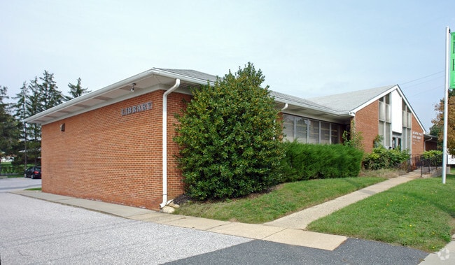
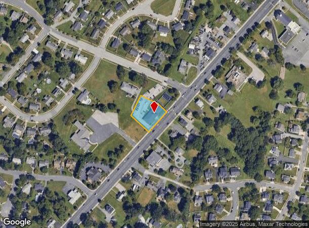
Property Record
9440 Belair Rd, Nottingham, MD 21236
NEARBY LISTINGS FOR SALE OR LEASE
Property Detail
9440 Belair Rd
11-1102000143
IMPS .56 AC
Daycare
Baltimore
X
Maryland
2400100290G
0.56 AC
2024
Baltimore County East
2025
Baltimore
411406
Baltimore-Columbia-Towson, MD
5,276 SF
DEMOGRAPHICS near 9440 Belair Rd
1 Mile
3 Mile
5 Mile
2024 Total Population
13,309
69,936
158,614
2029 Population
13,115
69,039
156,317
Pop Growth 2024-2029
(1.46%)
(1.28%)
(1.45%)
Average Age
44
42
41
2024 Total Households
5,211
27,155
61,989
HH Growth 2024-2029
(1.48%)
(1.42%)
(1.56%)
Median Household Inc
$96,861
$94,766
$84,787
Avg Household Size
2.50
2.50
2.50
2024 Avg HH Vehicles
2.00
2.00
2.00
Median Home Value
$331,729
$329,367
$300,215
Median Year Built
1981
1985
1978
Nearby Places
Map Layers
Map Styles
 Street
 Aerial
- Restaurants
- Banks
- Shops
- Fitness
- Groceries
PUBLIC TRANSPORTATION
COMMUTER RAIL
Martin State Airport (PENN - WASHINGTON - Maryland Area Regional Commuter Trains (The MARC), Penn Line - Maryland Area Regional Commuter Trains (The MARC))
DRIVE
WALK
Distance
Martin State Airport (PENN - WASHINGTON - Maryland Area Regional Commuter Trains (The MARC), Penn Line - Maryland Area Regional Commuter Trains (The MARC))
17 min
8.8 mi
AIRPORT
Baltimore/Washington International Thurgood Marshall
DRIVE
WALK
Distance
Baltimore/Washington International Thurgood Marshall
40 min
24.4 mi
Freight Ports
Port of Baltimore
DRIVE
WALK
Distance
Port of Baltimore
27 min
15.7 mi
SALE & LEASE HISTORY
LISTING DATE
SALE/LEASE

Sep 25, 2016
For Lease
Jun 01, 2017
For Lease
Nearby Properties
Address
Land Use
TOTAL SIZE
Lot Size
Zoning
Address
Land Use
TOTAL SIZE
Lot Size
Zoning
1,704,075 SF
76.16 AC
Address
Land Use
TOTAL SIZE
Lot Size
Zoning
307,785 SF
30.50 AC
ML
Address
Land Use
TOTAL SIZE
Lot Size
Zoning
527,364 SF
18.11 AC
BM
Address
Land Use
TOTAL SIZE
Lot Size
Zoning
474,640 SF
12.42 AC
Address
Land Use
TOTAL SIZE
Lot Size
Zoning
584,740 SF
32.61 AC
Address
Land Use
TOTAL SIZE
Lot Size
Zoning
16.08 AC
DR16
Address
Land Use
TOTAL SIZE
Lot Size
Zoning
15.29 AC
Address
Land Use
TOTAL SIZE
Lot Size
Zoning
19.93 AC
Address
Land Use
TOTAL SIZE
Lot Size
Zoning
214,738 SF
5.92 AC
Address
Land Use
TOTAL SIZE
Lot Size
Zoning
190,826 SF
9.89 AC
Address
Land Use
TOTAL SIZE
Lot Size
Zoning
240,121 SF
9.97 AC
Address
Land Use
TOTAL SIZE
Lot Size
Zoning
12.20 AC
DR16
Address
Land Use
TOTAL SIZE
Lot Size
Zoning
225,070 SF
20.65 AC
Address
Land Use
TOTAL SIZE
Lot Size
Zoning
239,798 SF
11.90 AC
Address
Land Use
TOTAL SIZE
Lot Size
Zoning
9.27 AC
DR105
Address
Land Use
TOTAL SIZE
Lot Size
Zoning
222,711 SF
39.21 AC
DR55
Address
Land Use
TOTAL SIZE
Lot Size
Zoning
9.54 AC
DR16
Address
Land Use
TOTAL SIZE
Lot Size
Zoning
7.72 AC
DR5.5
Address
Land Use
TOTAL SIZE
Lot Size
Zoning
64,480 SF
20.43 AC
Address
Land Use
TOTAL SIZE
Lot Size
Zoning
427,720 SF
27.55 AC
ML
Address
Land Use
TOTAL SIZE
Lot Size
Zoning
10.51 AC
DR16
Address
Land Use
TOTAL SIZE
Lot Size
Zoning
12.81 AC
DR16
Address
Land Use
TOTAL SIZE
Lot Size
Zoning
7.38 AC
DR16
Address
Land Use
TOTAL SIZE
Lot Size
Zoning
12.09 AC
DR5.5
Address
Land Use
TOTAL SIZE
Lot Size
Zoning
7.85 AC
DR5.5
Address
Land Use
TOTAL SIZE
Lot Size
Zoning
9.79 AC
DR5.5
Address
Land Use
TOTAL SIZE
Lot Size
Zoning
11.25 AC
DR16
Address
Land Use
TOTAL SIZE
Lot Size
Zoning
11.57 AC
DR16
Address
Land Use
TOTAL SIZE
Lot Size
Zoning
13.85 AC
DR5.5
Address
Land Use
TOTAL SIZE
Lot Size
Zoning
13,708 SF
15.67 AC
BLCCC
The World's #1 Commercial Real Estate Marketplace
Connect with us
© 2025 CoStar Group
The information above has been obtained from sources believed reliable. While we do not doubt its accuracy we have not verified it and make no guarantee, warranty or representation about it. It is your responsibility to independently confirm its accuracy and completeness. Any projections, opinions, assumptions, or estimates used are for example only and do not represent the current or future performance of the property. The value of this transaction to you depends on tax and other factors which should be evaluated by your tax, financial, and legal advisors. You and your advisors should conduct a careful, independent investigation of the property to determine to your satisfaction the suitability of the property for your needs.