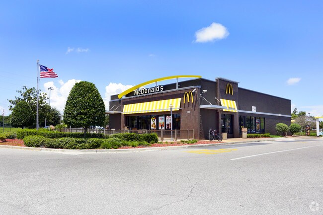
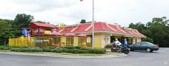
Property Record
9441 State Road 52, Hudson, FL 34669
NEARBY LISTINGS FOR SALE OR LEASE
Property Detail
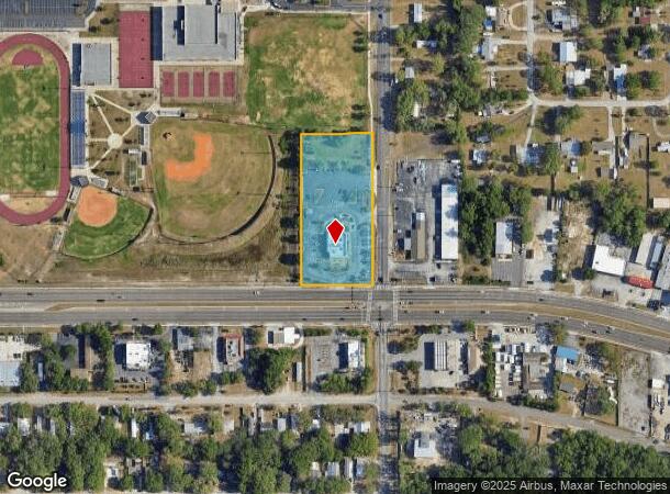
9441 State Road 52
Tampa-St. Petersburg-Clearwater, FL
Griffin Park
01-25-16-0090-02200-0010
GRIFFIN PARK UNIT 1 PB 4 PG 36 THAT POR OF VACATED PLAT & ALLEY DESC AS COM CENTERLINE OF ST RD 52 & CENTERLINE OF CHICAGO AVE TH N00DEG2105W 95.40 FT TO NE COR OF NW1/4 OF SEC TH S89DEG5602W 25.00 FT ALG NORTH BDY OF SEC FOR POB TH S00DEG2106E 45.34
Restaurantdrivein
Pasco
X
Florida
12101C0183G
1
2024
2.45 AC
2026
Pasco County
031205
Tampa/St Petersburg
4,983 SF
DEMOGRAPHICS near 9441 State Road 52
1 Mile
3 Mile
5 Mile
2024 Total Population
5,926
61,551
123,734
2029 Population
7,122
73,804
148,559
Pop Growth 2024-2029
+ 20.18%
+ 19.91%
+ 20.06%
Average Age
45
47
45
2024 Total Households
2,584
27,080
52,864
HH Growth 2024-2029
+ 20.05%
+ 19.91%
+ 20.06%
Median Household Inc
$42,949
$44,100
$46,997
Avg Household Size
2.30
2.20
2.30
2024 Avg HH Vehicles
1.00
2.00
2.00
Median Home Value
$135,767
$149,270
$164,099
Median Year Built
1982
1981
1982
Nearby Places
Map Layers
Map Styles
 Street
 Aerial
- Restaurants
- Banks
- Shops
- Fitness
- Groceries
PUBLIC TRANSPORTATION
AIRPORT
Tampa International
DRIVE
WALK
Distance
Tampa International
51 min
36.6 mi
St Pete-Clearwater International
DRIVE
WALK
Distance
St Pete-Clearwater International
63 min
36.7 mi
Nearby Properties
Address
Land Use
TOTAL SIZE
Lot Size
Zoning
Address
Land Use
TOTAL SIZE
Lot Size
Zoning
250,601 SF
38.64 AC
C2
Address
Land Use
TOTAL SIZE
Lot Size
Zoning
414,111 SF
23.78 AC
C1
Address
Land Use
TOTAL SIZE
Lot Size
Zoning
233,384 SF
29.06 AC
MPUD
Address
Land Use
TOTAL SIZE
Lot Size
Zoning
218,736 SF
39.17 AC
R1
Address
Land Use
TOTAL SIZE
Lot Size
Zoning
459,499 SF
100 AC
AR
Address
Land Use
TOTAL SIZE
Lot Size
Zoning
124,316 SF
22.91 AC
MF1
Address
Land Use
TOTAL SIZE
Lot Size
Zoning
124,470 SF
5.09 AC
C2
Address
Land Use
TOTAL SIZE
Lot Size
Zoning
103,743 SF
30.16 AC
MF1
Address
Land Use
TOTAL SIZE
Lot Size
Zoning
189,166 SF
18.19 AC
C2
Address
Land Use
TOTAL SIZE
Lot Size
Zoning
106,741 SF
27.67 AC
MF1
Address
Land Use
TOTAL SIZE
Lot Size
Zoning
217,758 SF
34.95 AC
C2
Address
Land Use
TOTAL SIZE
Lot Size
Zoning
190,794 SF
10.88 AC
C2
Address
Land Use
TOTAL SIZE
Lot Size
Zoning
86,570 SF
8.06 AC
MF1
Address
Land Use
TOTAL SIZE
Lot Size
Zoning
111,060 SF
9.31 AC
C3
Address
Land Use
TOTAL SIZE
Lot Size
Zoning
75,205 SF
12.71 AC
PUD
Address
Land Use
TOTAL SIZE
Lot Size
Zoning
85,003 SF
25 AC
R4
Address
Land Use
TOTAL SIZE
Lot Size
Zoning
81,839 SF
3.33 AC
C2
Address
Land Use
TOTAL SIZE
Lot Size
Zoning
48,470 SF
4.19 AC
MPUD
Address
Land Use
TOTAL SIZE
Lot Size
Zoning
90,113 SF
8.22 AC
C2
Address
Land Use
TOTAL SIZE
Lot Size
Zoning
83,363 SF
5.97 AC
C2
Address
Land Use
TOTAL SIZE
Lot Size
Zoning
78,580 SF
21.43 AC
PUD
Address
Land Use
TOTAL SIZE
Lot Size
Zoning
38,187 SF
6.48 AC
MPUD
Address
Land Use
TOTAL SIZE
Lot Size
Zoning
80,025 SF
10.55 AC
MF2
Address
Land Use
TOTAL SIZE
Lot Size
Zoning
85,971 SF
16.58 AC
C2
Address
Land Use
TOTAL SIZE
Lot Size
Zoning
52,704 SF
5 AC
MF2
Address
Land Use
TOTAL SIZE
Lot Size
Zoning
107,560 SF
5.96 AC
C2
Address
Land Use
TOTAL SIZE
Lot Size
Zoning
171,441 SF
8.70 AC
MF2
Address
Land Use
TOTAL SIZE
Lot Size
Zoning
188,871 SF
8.44 AC
C1
Address
Land Use
TOTAL SIZE
Lot Size
Zoning
49,118 SF
7.72 AC
C2
Address
Land Use
TOTAL SIZE
Lot Size
Zoning
51,540 SF
3.07 AC
C2
The World's #1 Commercial Real Estate Marketplace
Connect with us
© 2026 CoStar Group
The information above has been obtained from sources believed reliable. While we do not doubt its accuracy we have not verified it and make no guarantee, warranty or representation about it. It is your responsibility to independently confirm its accuracy and completeness. Any projections, opinions, assumptions, or estimates used are for example only and do not represent the current or future performance of the property. The value of this transaction to you depends on tax and other factors which should be evaluated by your tax, financial, and legal advisors. You and your advisors should conduct a careful, independent investigation of the property to determine to your satisfaction the suitability of the property for your needs.