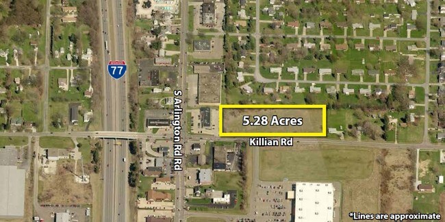
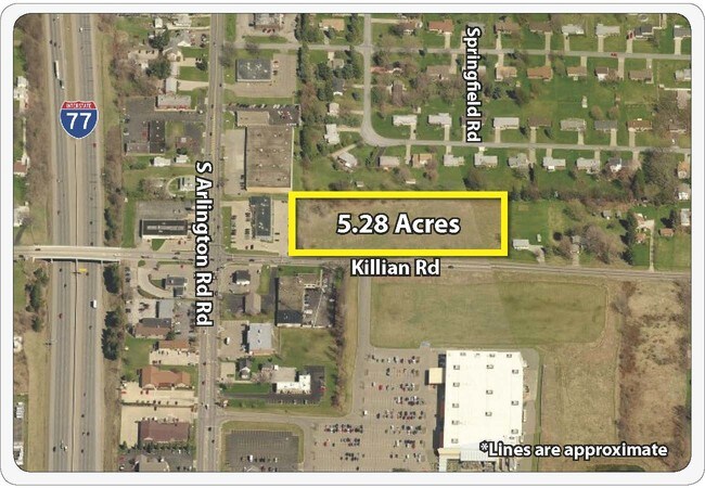
Property Record
945 Killian Rd, Akron, OH 44312
Property Detail
945 Killian Rd
Akron, OH
TR 1 N OF KILLIAN RD 2.000A
51-03164
SUMMIT
Residentialacreage
Ohio
2023
2.72 AC
2025
Akron
531103
Cleveland
528 SF
NEARBY LISTINGS FOR SALE OR LEASE
DEMOGRAPHICS near 945 Killian Rd
1 mile
3 mile
5 mile
2025 Total Population
2,539
33,648
127,695
2030 Population
2,549
33,729
128,237
Pop Growth 2025-2030
+ 0.39%
+ 0.24%
+ 0.42%
Average Age
44
43
41
2025 Total Households
1,078
14,666
54,578
HH Growth 2025-2030
+ 0.37%
+ 0.23%
+ 0.40%
Median Household Inc
$87,694
$68,481
$59,285
Avg Household Size
2.30
2.30
2.30
2025 Avg HH Vehicles
2.00
2.00
2.00
Median Home Value
$211,207
$203,930
$170,388
Median Year Built
1977
1970
1960
Nearby Places
Map Layers
Map Styles
 Street
 Aerial
Transit
 Traffic
 Biking
Places
Listings with unknown addresses are not visible on the map
- Restaurants
- Banks
- Shops
- Fitness
- Groceries
PUBLIC TRANSPORTATION
COMMUTER RAIL
Akron Northside (National Park Scenic Railway - Cuyahoga Valley Scenic Railroad)
Drive
Walk
Distance
Akron Northside (National Park Scenic Railway - Cuyahoga Valley Scenic Railroad)
14 min
8.4 mi
AIRPORT
Akron-Canton Regional
Drive
Walk
Distance
Akron-Canton Regional
11 min
7.6 mi
Freight Ports
Port of Toledo
Drive
Walk
Distance
Port of Toledo
169 min
142.7 mi
SALE & LEASE HISTORY
LISTING DATE
SALE/LEASE

Sep 24, 2016
For Sale
Nearby Properties
Address
Land Use
TOTAL SIZE
Lot Size
Zoning
Address
Land Use
TOTAL SIZE
Lot Size
Zoning
Address
Land Use
TOTAL SIZE
Lot Size
Zoning
57,369 SF
93.97 AC
Address
Land Use
TOTAL SIZE
Lot Size
Zoning
Address
Land Use
TOTAL SIZE
Lot Size
Zoning
Address
Land Use
TOTAL SIZE
Lot Size
Zoning
227,634 SF
21.46 AC
Address
Land Use
TOTAL SIZE
Lot Size
Zoning
Address
Land Use
TOTAL SIZE
Lot Size
Zoning
116,456 SF
76.66 AC
Address
Land Use
TOTAL SIZE
Lot Size
Zoning
Address
Land Use
TOTAL SIZE
Lot Size
Zoning
639,478 SF
29.51 AC
Address
Land Use
TOTAL SIZE
Lot Size
Zoning
22,589 SF
31.65 AC
Address
Land Use
TOTAL SIZE
Lot Size
Zoning
121,006 SF
6.09 AC
Address
Land Use
TOTAL SIZE
Lot Size
Zoning
22,977 SF
263.47 AC
Address
Land Use
TOTAL SIZE
Lot Size
Zoning
72,614 SF
14.91 AC
Address
Land Use
TOTAL SIZE
Lot Size
Zoning
Address
Land Use
TOTAL SIZE
Lot Size
Zoning
203,059 SF
55.62 AC
Address
Land Use
TOTAL SIZE
Lot Size
Zoning
232,425 SF
13.37 AC
Address
Land Use
TOTAL SIZE
Lot Size
Zoning
2.08 AC
Address
Land Use
TOTAL SIZE
Lot Size
Zoning
78,302 SF
19.73 AC
Address
Land Use
TOTAL SIZE
Lot Size
Zoning
Address
Land Use
TOTAL SIZE
Lot Size
Zoning
16,604 SF
248.86 AC
Address
Land Use
TOTAL SIZE
Lot Size
Zoning
21,794 SF
8.78 AC
Address
Land Use
TOTAL SIZE
Lot Size
Zoning
57,782 SF
10.13 AC
Address
Land Use
TOTAL SIZE
Lot Size
Zoning
69,372 SF
7.86 AC
Address
Land Use
TOTAL SIZE
Lot Size
Zoning
187,454 SF
12.59 AC
Address
Land Use
TOTAL SIZE
Lot Size
Zoning
243,424 SF
13.24 AC
Address
Land Use
TOTAL SIZE
Lot Size
Zoning
156,522 SF
24.05 AC
Address
Land Use
TOTAL SIZE
Lot Size
Zoning
179,780 SF
15.02 AC
Address
Land Use
TOTAL SIZE
Lot Size
Zoning
88,884 SF
0.96 AC
Address
Land Use
TOTAL SIZE
Lot Size
Zoning
Address
Land Use
TOTAL SIZE
Lot Size
Zoning
24,024 SF
1.04 AC
The World's #1 Commercial Real Estate Marketplace
Connect with us
© 2026 CoStar Group
The information above has been obtained from sources believed reliable. While we do not doubt its accuracy we have not verified it and make no guarantee, warranty or representation about it. It is your responsibility to independently confirm its accuracy and completeness. Any projections, opinions, assumptions, or estimates used are for example only and do not represent the current or future performance of the property. The value of this transaction to you depends on tax and other factors which should be evaluated by your tax, financial, and legal advisors. You and your advisors should conduct a careful, independent investigation of the property to determine to your satisfaction the suitability of the property for your needs.