Property Record
945 N Main St, Tekonsha, MI 49092

Save to a Folder
{{folder.Name}}
{{folder.ListingIds.length}} Properties
{{folder.ListingIds.length}} Property
Create a New Folder
Property Detail
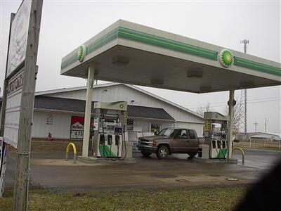
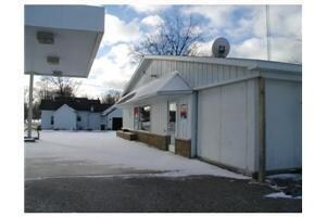
945 N Main St
44-027-012-01
VILLAGE OF TEKONSHA/T4S R6W, SEC 27: PART W1/2 NE1/4 COM N00DEG 02'25"E 2221.77 FT & N88DEG 41'42"W 41.26 FT FROM SE COR
Autorepair
Calhoun
C-2
Michigan
B and X Area of moderate flood hazard, usually the area between the limits of the 100-year and 500-year floods.
0.98 AC
2025
Eastern Calhoun County
2026
West Michigan
002900
Battle Creek, MI
6,994 SF
NEARBY LISTINGS FOR SALE OR LEASE
-
-
View all Tekonsha listings for sale on LoopNet.com
DEMOGRAPHICS near 945 N Main St
1 mile
3 mile
5 mile
2025 Total Population
713
1,293
2,909
2030 Population
702
1,279
2,891
Pop Growth 2025-2030
(1.54%)
(1.08%)
(0.62%)
Average Age
43
44
44
2025 Total Households
305
550
1,190
HH Growth 2025-2030
(1.31%)
(0.91%)
(0.59%)
Median Household Inc
$59,285
$64,050
$67,171
Avg Household Size
2.30
2.30
2.40
2025 Avg HH Vehicles
2.00
2.00
2.00
Median Home Value
$126,966
$153,124
$179,729
Median Year Built
1950
1954
1959
Nearby Places
Map Layers
Map Styles
 Street
 Aerial
Layers
 Traffic
 Biking
Places
Listings with unknown addresses are not visible on the map
- Restaurants
- Banks
- Shops
- Fitness
- Groceries
SALE & LEASE HISTORY
LISTING DATE
SALE/LEASE

Apr 10, 2018
For Sale
Nearby Properties
Address
Land Use
TOTAL SIZE
Lot Size
Zoning
Address
Land Use
TOTAL SIZE
Lot Size
Zoning
73,702 SF
13.78 AC
LI
Address
Land Use
TOTAL SIZE
Lot Size
Zoning
12,744 SF
9.54 AC
C-3
Address
Land Use
TOTAL SIZE
Lot Size
Zoning
21,600 SF
4.68 AC
HI
Address
Land Use
TOTAL SIZE
Lot Size
Zoning
160.59 AC
AGRI RES
Address
Land Use
TOTAL SIZE
Lot Size
Zoning
120 AC
AGRI RES
Address
Land Use
TOTAL SIZE
Lot Size
Zoning
127.30 AC
AGRI RES
Address
Land Use
TOTAL SIZE
Lot Size
Zoning
Address
Land Use
TOTAL SIZE
Lot Size
Zoning
102.20 AC
AGRI RES
Address
Land Use
TOTAL SIZE
Lot Size
Zoning
Address
Land Use
TOTAL SIZE
Lot Size
Zoning
79.50 AC
Address
Land Use
TOTAL SIZE
Lot Size
Zoning
100 AC
Address
Land Use
TOTAL SIZE
Lot Size
Zoning
128 AC
AGRI RES
Address
Land Use
TOTAL SIZE
Lot Size
Zoning
103 AC
AGRI RES
Address
Land Use
TOTAL SIZE
Lot Size
Zoning
141 AC
AGRI RES
Address
Land Use
TOTAL SIZE
Lot Size
Zoning
160 AC
Address
Land Use
TOTAL SIZE
Lot Size
Zoning
101 AC
AGRI RES
Address
Land Use
TOTAL SIZE
Lot Size
Zoning
88 AC
AGRI RES
Address
Land Use
TOTAL SIZE
Lot Size
Zoning
9,086 SF
3.73 AC
COMMERCIAL
Address
Land Use
TOTAL SIZE
Lot Size
Zoning
80 AC
AGRI RES
Address
Land Use
TOTAL SIZE
Lot Size
Zoning
80 AC
AGRI RES
Address
Land Use
TOTAL SIZE
Lot Size
Zoning
Address
Land Use
TOTAL SIZE
Lot Size
Zoning
140 AC
AGRI RES
Address
Land Use
TOTAL SIZE
Lot Size
Zoning
78.85 AC
AGRI RES
Address
Land Use
TOTAL SIZE
Lot Size
Zoning
6,459 SF
16.09 AC
HI
Address
Land Use
TOTAL SIZE
Lot Size
Zoning
19,300 SF
2.61 AC
LI
Address
Land Use
TOTAL SIZE
Lot Size
Zoning
3,834 SF
3.60 AC
C-3
Address
Land Use
TOTAL SIZE
Lot Size
Zoning
6,589 SF
0.80 AC
C-2
Address
Land Use
TOTAL SIZE
Lot Size
Zoning
78.70 AC
AGRI RES
Address
Land Use
TOTAL SIZE
Lot Size
Zoning
80 AC
AGRI RES
Address
Land Use
TOTAL SIZE
Lot Size
Zoning
120 AC
AGRI RES
The World's #1 Commercial Real Estate Marketplace
Connect with us
© 2026 CoStar Group
The information above has been obtained from sources believed reliable. While we do not doubt its accuracy we have not verified it and make no guarantee, warranty or representation about it. It is your responsibility to independently confirm its accuracy and completeness. Any projections, opinions, assumptions, or estimates used are for example only and do not represent the current or future performance of the property. The value of this transaction to you depends on tax and other factors which should be evaluated by your tax, financial, and legal advisors. You and your advisors should conduct a careful, independent investigation of the property to determine to your satisfaction the suitability of the property for your needs.