Property Record
945 Orchard St, New Suffolk, NY 11956
NEARBY LISTINGS FOR SALE OR LEASE
-
-
View all New Suffolk listings for sale on LoopNet.com
Property Detail
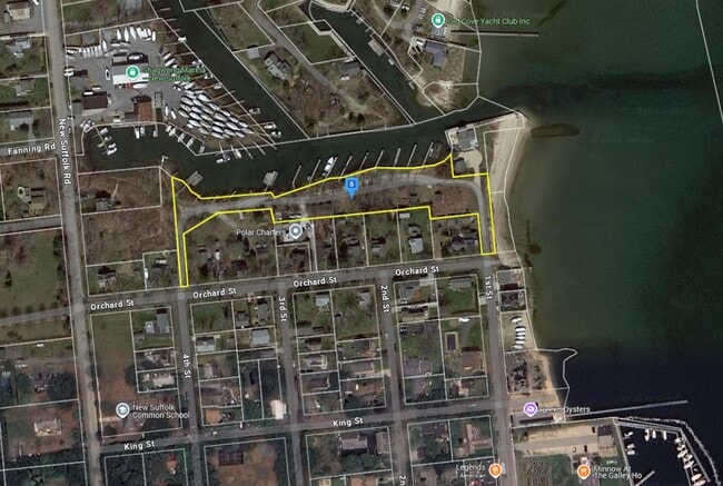
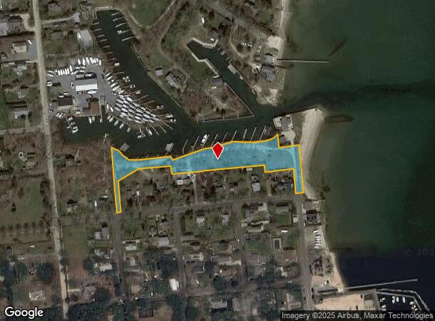
945 Orchard St
Nassau County-Suffolk County, NY
BOOK 4 PAGE 00175 BILL 015122
1000-117-00-05-00-046-004
Suffolk
Portharbor
New York
AE
46
36103C0501H
1.75 AC
2024
Eastern Suffolk
2024
Long Island (New York)
170005
DEMOGRAPHICS near 945 Orchard St
1 Mile
3 Mile
5 Mile
2024 Total Population
693
7,150
18,767
2029 Population
716
7,598
19,935
Pop Growth 2024-2029
+ 3.32%
+ 6.27%
+ 6.22%
Average Age
50
48
47
2024 Total Households
301
2,942
7,689
HH Growth 2024-2029
+ 2.99%
+ 6.25%
+ 6.14%
Median Household Inc
$99,184
$121,920
$122,285
Avg Household Size
2.20
2.30
2.40
2024 Avg HH Vehicles
2.00
2.00
2.00
Median Home Value
$826,086
$852,681
$834,534
Median Year Built
1968
1974
1975
Nearby Places
- Restaurants
- Banks
- Shops
- Fitness
- Groceries
PUBLIC TRANSPORTATION
COMMUTER RAIL
Mattituck Station (Greenport Branch - Long Island Rail Road)
DRIVE
WALK
Distance
Mattituck Station (Greenport Branch - Long Island Rail Road)
9 min
3.7 mi
Southold Station (Greenport Branch - Long Island Rail Road)
DRIVE
WALK
Distance
Southold Station (Greenport Branch - Long Island Rail Road)
13 min
6.6 mi
Freight Ports
Port of New Haven
DRIVE
WALK
Distance
Port of New Haven
168 min
71.1 mi
Nearby Properties
Address
Land Use
TOTAL SIZE
Lot Size
Zoning
Address
Land Use
TOTAL SIZE
Lot Size
Zoning
30.40 AC
R-80
Address
Land Use
TOTAL SIZE
Lot Size
Zoning
26.14 AC
R-80
Address
Land Use
TOTAL SIZE
Lot Size
Zoning
0.79 AC
VILLA
Address
Land Use
TOTAL SIZE
Lot Size
Zoning
Address
Land Use
TOTAL SIZE
Lot Size
Zoning
5.60 AC
RO R-40
Address
Land Use
TOTAL SIZE
Lot Size
Zoning
4.91 AC
B
Address
Land Use
TOTAL SIZE
Lot Size
Zoning
0.47 AC
BUS1
Address
Land Use
TOTAL SIZE
Lot Size
Zoning
78.34 AC
AC
Address
Land Use
TOTAL SIZE
Lot Size
Zoning
Address
Land Use
TOTAL SIZE
Lot Size
Zoning
32.26 AC
R-80 R-40
Address
Land Use
TOTAL SIZE
Lot Size
Zoning
7.20 AC
AC
Address
Land Use
TOTAL SIZE
Lot Size
Zoning
59.94 AC
LI
Address
Land Use
TOTAL SIZE
Lot Size
Zoning
6 AC
R-40
Address
Land Use
TOTAL SIZE
Lot Size
Zoning
10.70 AC
R-40
Address
Land Use
TOTAL SIZE
Lot Size
Zoning
6.84 AC
AC
Address
Land Use
TOTAL SIZE
Lot Size
Zoning
Address
Land Use
TOTAL SIZE
Lot Size
Zoning
99.76 AC
AC R-40
Address
Land Use
TOTAL SIZE
Lot Size
Zoning
1.50 AC
RO R-40
Address
Land Use
TOTAL SIZE
Lot Size
Zoning
6.52 AC
LI
Address
Land Use
TOTAL SIZE
Lot Size
Zoning
3.07 AC
LI
Address
Land Use
TOTAL SIZE
Lot Size
Zoning
21.24 AC
HD
Address
Land Use
TOTAL SIZE
Lot Size
Zoning
2.61 AC
AC
Address
Land Use
TOTAL SIZE
Lot Size
Zoning
2.75 AC
LIO
Address
Land Use
TOTAL SIZE
Lot Size
Zoning
Address
Land Use
TOTAL SIZE
Lot Size
Zoning
3.90 AC
MI
Address
Land Use
TOTAL SIZE
Lot Size
Zoning
1.50 AC
R-40
Address
Land Use
TOTAL SIZE
Lot Size
Zoning
0.75 AC
R-40
Address
Land Use
TOTAL SIZE
Lot Size
Zoning
36 AC
AC
Address
Land Use
TOTAL SIZE
Lot Size
Zoning
35.92 AC
AC
Address
Land Use
TOTAL SIZE
Lot Size
Zoning
3.08 AC
B
The World's #1 Commercial Real Estate Marketplace
Connect with us
© 2025 CoStar Group
The information above has been obtained from sources believed reliable. While we do not doubt its accuracy we have not verified it and make no guarantee, warranty or representation about it. It is your responsibility to independently confirm its accuracy and completeness. Any projections, opinions, assumptions, or estimates used are for example only and do not represent the current or future performance of the property. The value of this transaction to you depends on tax and other factors which should be evaluated by your tax, financial, and legal advisors. You and your advisors should conduct a careful, independent investigation of the property to determine to your satisfaction the suitability of the property for your needs.