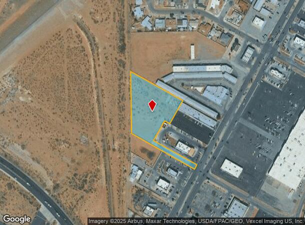
Property Record
9459 Dyer St, El Paso, TX 79924


This Property Is For Sale
NEARBY LISTINGS FOR SALE OR LEASE
Property Detail
9459 Dyer St
El Paso
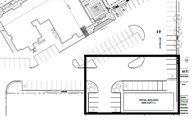
Northgate Mcdonalds
El Paso, TX
BLK 1 NORTHGATE MCDONALDS LOT 2
N582-999-0010-0200
El Paso
Commercialnec
Texas
2024
2
2025
2.52 AC
000110
Northeast
DEMOGRAPHICS near 9459 Dyer St
1 Mile
3 Mile
5 Mile
2024 Total Population
14,776
74,892
124,658
2029 Population
14,953
75,862
126,035
Pop Growth 2024-2029
+ 1.20%
+ 1.30%
+ 1.10%
Average Age
39
37
36
2024 Total Households
5,551
27,523
44,454
HH Growth 2024-2029
+ 1.42%
+ 1.37%
+ 1.16%
Median Household Inc
$39,872
$42,294
$47,313
Avg Household Size
2.60
2.70
2.70
2024 Avg HH Vehicles
2.00
2.00
2.00
Median Home Value
$123,789
$126,425
$137,012
Median Year Built
1967
1972
1978
Nearby Places
Map Layers
Map Styles
 Street
 Aerial
- Restaurants
- Banks
- Shops
- Fitness
- Groceries
PUBLIC TRANSPORTATION
AIRPORT
El Paso International
DRIVE
WALK
Distance
El Paso International
21 min
10.5 mi
Freight Ports
Port of Corpus Christi
DRIVE
WALK
Distance
Port of Corpus Christi
689 min
699.6 mi
Nearby Properties
Address
Land Use
TOTAL SIZE
Lot Size
Zoning
Address
Land Use
TOTAL SIZE
Lot Size
Zoning
427,550 SF
40 AC
R4
Address
Land Use
TOTAL SIZE
Lot Size
Zoning
261,148 SF
21.61 AC
PR2
Address
Land Use
TOTAL SIZE
Lot Size
Zoning
117,210 SF
8.55 AC
R4
Address
Land Use
TOTAL SIZE
Lot Size
Zoning
73,904 SF
42.88 AC
R4
Address
Land Use
TOTAL SIZE
Lot Size
Zoning
136,000 SF
84.83 AC
R4
Address
Land Use
TOTAL SIZE
Lot Size
Zoning
148,277 SF
17.14 AC
R4
Address
Land Use
TOTAL SIZE
Lot Size
Zoning
322,175 SF
22.17 AC
M1
Address
Land Use
TOTAL SIZE
Lot Size
Zoning
240,114 SF
26.84 AC
C1
Address
Land Use
TOTAL SIZE
Lot Size
Zoning
348,316 SF
39.67 AC
R4
Address
Land Use
TOTAL SIZE
Lot Size
Zoning
177.87 AC
Address
Land Use
TOTAL SIZE
Lot Size
Zoning
468,270 SF
60 AC
M1
Address
Land Use
TOTAL SIZE
Lot Size
Zoning
140,086 SF
13.13 AC
C3
Address
Land Use
TOTAL SIZE
Lot Size
Zoning
251,542 SF
12.76 AC
C1
Address
Land Use
TOTAL SIZE
Lot Size
Zoning
88,806 SF
9.41 AC
C1S
Address
Land Use
TOTAL SIZE
Lot Size
Zoning
112,888 SF
5.60 AC
SCZ
Address
Land Use
TOTAL SIZE
Lot Size
Zoning
231,035 SF
15.85 AC
R3
Address
Land Use
TOTAL SIZE
Lot Size
Zoning
28,289 SF
3.31 AC
C1
Address
Land Use
TOTAL SIZE
Lot Size
Zoning
136,880 SF
19.21 AC
C3
Address
Land Use
TOTAL SIZE
Lot Size
Zoning
67,808 SF
9.64 AC
C1
Address
Land Use
TOTAL SIZE
Lot Size
Zoning
44,178 SF
1.03 AC
A1C
Address
Land Use
TOTAL SIZE
Lot Size
Zoning
102,026 SF
5.90 AC
M1
Address
Land Use
TOTAL SIZE
Lot Size
Zoning
78,875 SF
6.41 AC
C3
Address
Land Use
TOTAL SIZE
Lot Size
Zoning
133,538 SF
10.04 AC
C1
Address
Land Use
TOTAL SIZE
Lot Size
Zoning
219,241 SF
6.92 AC
M1
Address
Land Use
TOTAL SIZE
Lot Size
Zoning
75,857 SF
C1
Address
Land Use
TOTAL SIZE
Lot Size
Zoning
113,724 SF
9.65 AC
C3
Address
Land Use
TOTAL SIZE
Lot Size
Zoning
27,963 SF
2 AC
C1
Address
Land Use
TOTAL SIZE
Lot Size
Zoning
211,730 SF
8.52 AC
C3S
Address
Land Use
TOTAL SIZE
Lot Size
Zoning
113,864 SF
11.34 AC
C4
Address
Land Use
TOTAL SIZE
Lot Size
Zoning
45,752 SF
3.05 AC
R4
The World's #1 Commercial Real Estate Marketplace
Connect with us
© 2026 CoStar Group
The information above has been obtained from sources believed reliable. While we do not doubt its accuracy we have not verified it and make no guarantee, warranty or representation about it. It is your responsibility to independently confirm its accuracy and completeness. Any projections, opinions, assumptions, or estimates used are for example only and do not represent the current or future performance of the property. The value of this transaction to you depends on tax and other factors which should be evaluated by your tax, financial, and legal advisors. You and your advisors should conduct a careful, independent investigation of the property to determine to your satisfaction the suitability of the property for your needs.