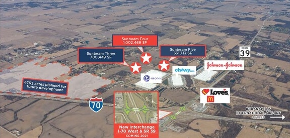
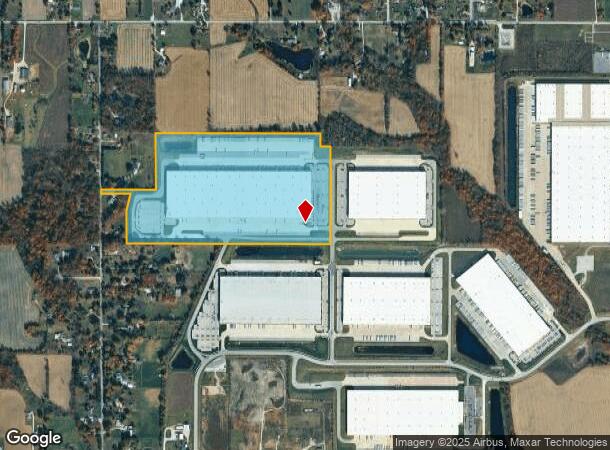
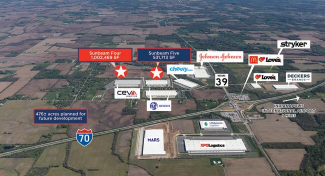
Property Record
9472 Distribution Dr, Clayton, IN 46118
NEARBY LISTINGS FOR SALE OR LEASE
Property Detail
9472 Distribution Dr
Indianapolis-Carmel-Anderson, IN
PT NE 1/4 26-14N-1W 69.65AC
32-14-26-105-001.000-013
Hendricks
Warehouse
Indiana
2024
69.65 AC
2024
West Hendricks Cty
211000
Indianapolis
DEMOGRAPHICS near 9472 Distribution Dr
1 Mile
3 Mile
5 Mile
2024 Total Population
459
3,212
10,521
2029 Population
509
3,430
11,166
Pop Growth 2024-2029
+ 10.89%
+ 6.79%
+ 6.13%
Average Age
44
41
42
2024 Total Households
178
1,186
3,949
HH Growth 2024-2029
+ 11.24%
+ 6.91%
+ 6.13%
Median Household Inc
$74,673
$79,358
$86,935
Avg Household Size
2.50
2.70
2.60
2024 Avg HH Vehicles
3.00
3.00
3.00
Median Home Value
$239,166
$211,748
$235,649
Median Year Built
1973
1985
1979
Nearby Places
Map Layers
Map Styles
 Street
 Aerial
- Restaurants
- Banks
- Shops
- Fitness
- Groceries
PUBLIC TRANSPORTATION
AIRPORT
Indianapolis International
DRIVE
WALK
Distance
Indianapolis International
22 min
14.0 mi
Freight Ports
Port of Toledo
DRIVE
WALK
Distance
Port of Toledo
300 min
248.9 mi
SALE & LEASE HISTORY
LISTING DATE
SALE/LEASE

Jan 28, 2021
For Lease
Nearby Properties
Address
Land Use
TOTAL SIZE
Lot Size
Zoning
Address
Land Use
TOTAL SIZE
Lot Size
Zoning
1,049,878 SF
113.60 AC
Address
Land Use
TOTAL SIZE
Lot Size
Zoning
76.76 AC
Address
Land Use
TOTAL SIZE
Lot Size
Zoning
60.85 AC
Address
Land Use
TOTAL SIZE
Lot Size
Zoning
43.38 AC
Address
Land Use
TOTAL SIZE
Lot Size
Zoning
52.40 AC
Address
Land Use
TOTAL SIZE
Lot Size
Zoning
577,046 SF
59.48 AC
Address
Land Use
TOTAL SIZE
Lot Size
Zoning
56.08 AC
Address
Land Use
TOTAL SIZE
Lot Size
Zoning
601,744 SF
44.09 AC
Address
Land Use
TOTAL SIZE
Lot Size
Zoning
Address
Land Use
TOTAL SIZE
Lot Size
Zoning
597,500 SF
44.22 AC
Address
Land Use
TOTAL SIZE
Lot Size
Zoning
34.54 AC
Address
Land Use
TOTAL SIZE
Lot Size
Zoning
26.24 AC
Address
Land Use
TOTAL SIZE
Lot Size
Zoning
37.89 AC
Address
Land Use
TOTAL SIZE
Lot Size
Zoning
67.08 AC
Address
Land Use
TOTAL SIZE
Lot Size
Zoning
20.47 AC
Address
Land Use
TOTAL SIZE
Lot Size
Zoning
12,152 SF
10.66 AC
Address
Land Use
TOTAL SIZE
Lot Size
Zoning
190.58 AC
Address
Land Use
TOTAL SIZE
Lot Size
Zoning
17,389 SF
13.79 AC
Address
Land Use
TOTAL SIZE
Lot Size
Zoning
71,402 SF
7.07 AC
Address
Land Use
TOTAL SIZE
Lot Size
Zoning
8,256 SF
1.03 AC
Address
Land Use
TOTAL SIZE
Lot Size
Zoning
15,306 SF
4.65 AC
Address
Land Use
TOTAL SIZE
Lot Size
Zoning
9,840 SF
16.49 AC
Address
Land Use
TOTAL SIZE
Lot Size
Zoning
2,392 SF
20.36 AC
Address
Land Use
TOTAL SIZE
Lot Size
Zoning
10,265 SF
116.12 AC
Address
Land Use
TOTAL SIZE
Lot Size
Zoning
Address
Land Use
TOTAL SIZE
Lot Size
Zoning
147.23 AC
Address
Land Use
TOTAL SIZE
Lot Size
Zoning
9,600 SF
5.19 AC
Address
Land Use
TOTAL SIZE
Lot Size
Zoning
The World's #1 Commercial Real Estate Marketplace
Connect with us
© 2025 CoStar Group
The information above has been obtained from sources believed reliable. While we do not doubt its accuracy we have not verified it and make no guarantee, warranty or representation about it. It is your responsibility to independently confirm its accuracy and completeness. Any projections, opinions, assumptions, or estimates used are for example only and do not represent the current or future performance of the property. The value of this transaction to you depends on tax and other factors which should be evaluated by your tax, financial, and legal advisors. You and your advisors should conduct a careful, independent investigation of the property to determine to your satisfaction the suitability of the property for your needs.