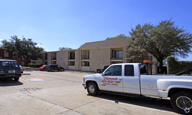
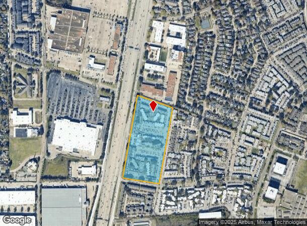
Property Record
9475 W Sam Houston Pkwy S, Houston, TX 77099

NEARBY LISTINGS FOR SALE OR LEASE
Property Detail
9475 W Sam Houston Pkwy S
1080570000002
Westwood Center Sec 1
Apartment
RES B2 & B3 BLK 2 WESTWOOD CENTER SEC 1
X
Harris
48201C0845M
Texas
2024
12.54 AC
2025
Westwood
433507
Houston
280,253 SF
Houston-The Woodlands-Sugar Land, TX
DEMOGRAPHICS near 9475 W Sam Houston Pkwy S
1 Mile
3 Mile
5 Mile
2024 Total Population
36,031
210,905
534,898
2029 Population
36,806
216,989
556,879
Pop Growth 2024-2029
+ 2.15%
+ 2.88%
+ 4.11%
Average Age
32
36
36
2024 Total Households
13,107
72,756
196,932
HH Growth 2024-2029
+ 2.02%
+ 3.05%
+ 4.09%
Median Household Inc
$31,477
$40,245
$44,222
Avg Household Size
2.70
2.80
2.60
2024 Avg HH Vehicles
1.00
2.00
2.00
Median Home Value
$157,519
$172,897
$207,046
Median Year Built
1982
1978
1980
Nearby Places
Map Layers
Map Styles
 Street
 Aerial
- Restaurants
- Banks
- Shops
- Fitness
- Groceries
PUBLIC TRANSPORTATION
AIRPORT
William P Hobby
DRIVE
WALK
Distance
William P Hobby
36 min
24.1 mi
George Bush Intcntl/Houston
DRIVE
WALK
Distance
George Bush Intcntl/Houston
40 min
34.2 mi
Freight Ports
Port of Houston
DRIVE
WALK
Distance
Port of Houston
37 min
24.0 mi
Nearby Properties
Address
Land Use
TOTAL SIZE
Lot Size
Zoning
Address
Land Use
TOTAL SIZE
Lot Size
Zoning
7.46 AC
Address
Land Use
TOTAL SIZE
Lot Size
Zoning
12.98 AC
Address
Land Use
TOTAL SIZE
Lot Size
Zoning
11.58 AC
Address
Land Use
TOTAL SIZE
Lot Size
Zoning
12.08 AC
Address
Land Use
TOTAL SIZE
Lot Size
Zoning
627,632 SF
24.12 AC
Address
Land Use
TOTAL SIZE
Lot Size
Zoning
816,006 SF
40.26 AC
Address
Land Use
TOTAL SIZE
Lot Size
Zoning
188,178 SF
18.49 AC
Address
Land Use
TOTAL SIZE
Lot Size
Zoning
771,720 SF
19.28 AC
Address
Land Use
TOTAL SIZE
Lot Size
Zoning
539,308 SF
21 AC
Address
Land Use
TOTAL SIZE
Lot Size
Zoning
76,385 SF
17.48 AC
Address
Land Use
TOTAL SIZE
Lot Size
Zoning
183,015 SF
9.91 AC
Address
Land Use
TOTAL SIZE
Lot Size
Zoning
322,894 SF
17.51 AC
Address
Land Use
TOTAL SIZE
Lot Size
Zoning
623,343 SF
22.89 AC
Address
Land Use
TOTAL SIZE
Lot Size
Zoning
725,466 SF
9.69 AC
Address
Land Use
TOTAL SIZE
Lot Size
Zoning
574,191 SF
8.32 AC
Address
Land Use
TOTAL SIZE
Lot Size
Zoning
355,887 SF
13.89 AC
Address
Land Use
TOTAL SIZE
Lot Size
Zoning
269,067 SF
17.98 AC
Address
Land Use
TOTAL SIZE
Lot Size
Zoning
364,674 SF
13.79 AC
Address
Land Use
TOTAL SIZE
Lot Size
Zoning
302,764 SF
13.12 AC
Address
Land Use
TOTAL SIZE
Lot Size
Zoning
307,488 SF
11 AC
Address
Land Use
TOTAL SIZE
Lot Size
Zoning
256,810 SF
22.65 AC
Address
Land Use
TOTAL SIZE
Lot Size
Zoning
274,158 SF
10.51 AC
Address
Land Use
TOTAL SIZE
Lot Size
Zoning
349,982 SF
18.44 AC
Address
Land Use
TOTAL SIZE
Lot Size
Zoning
280,309 SF
9.98 AC
Address
Land Use
TOTAL SIZE
Lot Size
Zoning
282,636 SF
4.18 AC
Address
Land Use
TOTAL SIZE
Lot Size
Zoning
185,541 SF
10.51 AC
Address
Land Use
TOTAL SIZE
Lot Size
Zoning
365,218 SF
25.48 AC
Address
Land Use
TOTAL SIZE
Lot Size
Zoning
272,600 SF
7.13 AC
Address
Land Use
TOTAL SIZE
Lot Size
Zoning
292,235 SF
9.78 AC
The World's #1 Commercial Real Estate Marketplace
Connect with us
© 2026 CoStar Group
The information above has been obtained from sources believed reliable. While we do not doubt its accuracy we have not verified it and make no guarantee, warranty or representation about it. It is your responsibility to independently confirm its accuracy and completeness. Any projections, opinions, assumptions, or estimates used are for example only and do not represent the current or future performance of the property. The value of this transaction to you depends on tax and other factors which should be evaluated by your tax, financial, and legal advisors. You and your advisors should conduct a careful, independent investigation of the property to determine to your satisfaction the suitability of the property for your needs.