Property Record
9477 N Mount Airey Dr, Eagle Mountain, UT 84005
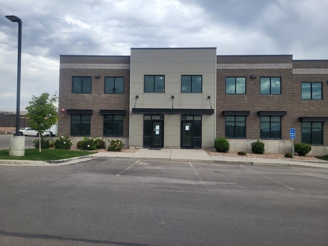

Property Detail
9477 N Mount Airey Dr
Provo-Orem-Lehi, UT
UNIT 106, PLAT 1A, GATEWAY PARK CONDOS. AREA 0.046 AC.
40-516-0102
UTAH
Industrialgeneral
Utah
2024
0.07 AC
2025
Utah County
010119
Salt Lake City
2,980 SF
NEARBY LISTINGS FOR SALE OR LEASE
DEMOGRAPHICS near 9477 N Mount Airey Dr
1 mile
3 mile
5 mile
2025 Total Population
5,799
58,270
110,233
2030 Population
6,492
65,533
124,317
Pop Growth 2025-2030
+ 11.95%
+ 12.46%
+ 12.78%
Average Age
28
27
28
2025 Total Households
1,384
14,397
27,902
HH Growth 2025-2030
+ 12.86%
+ 13.24%
+ 13.64%
Median Household Inc
$111,322
$114,368
$120,404
Avg Household Size
4.10
4.10
4.00
2025 Avg HH Vehicles
3.00
3.00
2.00
Median Home Value
$599,466
$625,431
$643,224
Median Year Built
2010
2010
2010
Nearby Places
Map Layers
Map Styles
 Street
 Aerial
Layers
 Traffic
 Biking
Places
Listings with unknown addresses are not visible on the map
- Restaurants
- Banks
- Shops
- Fitness
- Groceries
PUBLIC TRANSPORTATION
COMMUTER RAIL
Lehi Station (FrontRunner - Utah Transit Authority (UTA))
Drive
Walk
Distance
Lehi Station (FrontRunner - Utah Transit Authority (UTA))
13 min
7.1 mi
American Fork Station (FrontRunner - Utah Transit Authority (UTA))
Drive
Walk
Distance
American Fork Station (FrontRunner - Utah Transit Authority (UTA))
16 min
8.9 mi
AIRPORT
Provo Municipal
Drive
Walk
Distance
Provo Municipal
35 min
24.5 mi
Salt Lake City International
Drive
Walk
Distance
Salt Lake City International
46 min
36.7 mi
Freight Ports
Port of Stockton
Drive
Walk
Distance
Port of Stockton
742 min
714.4 mi
Nearby Properties
Address
Land Use
TOTAL SIZE
Lot Size
Zoning
Address
Land Use
TOTAL SIZE
Lot Size
Zoning
266,041 SF
11.28 AC
Address
Land Use
TOTAL SIZE
Lot Size
Zoning
61,537 SF
3 AC
Address
Land Use
TOTAL SIZE
Lot Size
Zoning
198,068 SF
20.72 AC
Address
Land Use
TOTAL SIZE
Lot Size
Zoning
123,381 SF
12.30 AC
Address
Land Use
TOTAL SIZE
Lot Size
Zoning
134,637 SF
16.98 AC
Address
Land Use
TOTAL SIZE
Lot Size
Zoning
99,862 SF
10.92 AC
Address
Land Use
TOTAL SIZE
Lot Size
Zoning
102,380 SF
9.10 AC
Address
Land Use
TOTAL SIZE
Lot Size
Zoning
64,605 SF
8.11 AC
Address
Land Use
TOTAL SIZE
Lot Size
Zoning
43,638 SF
40.32 AC
Address
Land Use
TOTAL SIZE
Lot Size
Zoning
11,050 SF
19.23 AC
Address
Land Use
TOTAL SIZE
Lot Size
Zoning
166,799 SF
11.39 AC
Address
Land Use
TOTAL SIZE
Lot Size
Zoning
59,672 SF
3.24 AC
Address
Land Use
TOTAL SIZE
Lot Size
Zoning
47,237 SF
4.14 AC
Address
Land Use
TOTAL SIZE
Lot Size
Zoning
54,965 SF
9.42 AC
Address
Land Use
TOTAL SIZE
Lot Size
Zoning
119,128 SF
3.78 AC
Address
Land Use
TOTAL SIZE
Lot Size
Zoning
56,652 SF
5.66 AC
Address
Land Use
TOTAL SIZE
Lot Size
Zoning
126,442 SF
7.06 AC
Address
Land Use
TOTAL SIZE
Lot Size
Zoning
Address
Land Use
TOTAL SIZE
Lot Size
Zoning
55,229 SF
4.61 AC
Address
Land Use
TOTAL SIZE
Lot Size
Zoning
85,318 SF
9.41 AC
Address
Land Use
TOTAL SIZE
Lot Size
Zoning
29,506 SF
10.10 AC
Address
Land Use
TOTAL SIZE
Lot Size
Zoning
25,547 SF
3.93 AC
Address
Land Use
TOTAL SIZE
Lot Size
Zoning
101,235 SF
4.83 AC
Address
Land Use
TOTAL SIZE
Lot Size
Zoning
Address
Land Use
TOTAL SIZE
Lot Size
Zoning
33,404 SF
3.40 AC
Address
Land Use
TOTAL SIZE
Lot Size
Zoning
20,990 SF
3.59 AC
Address
Land Use
TOTAL SIZE
Lot Size
Zoning
73,038 SF
3.61 AC
Address
Land Use
TOTAL SIZE
Lot Size
Zoning
21,615 SF
1.99 AC
The World's #1 Commercial Real Estate Marketplace
Connect with us
© 2026 CoStar Group
The information above has been obtained from sources believed reliable. While we do not doubt its accuracy we have not verified it and make no guarantee, warranty or representation about it. It is your responsibility to independently confirm its accuracy and completeness. Any projections, opinions, assumptions, or estimates used are for example only and do not represent the current or future performance of the property. The value of this transaction to you depends on tax and other factors which should be evaluated by your tax, financial, and legal advisors. You and your advisors should conduct a careful, independent investigation of the property to determine to your satisfaction the suitability of the property for your needs.