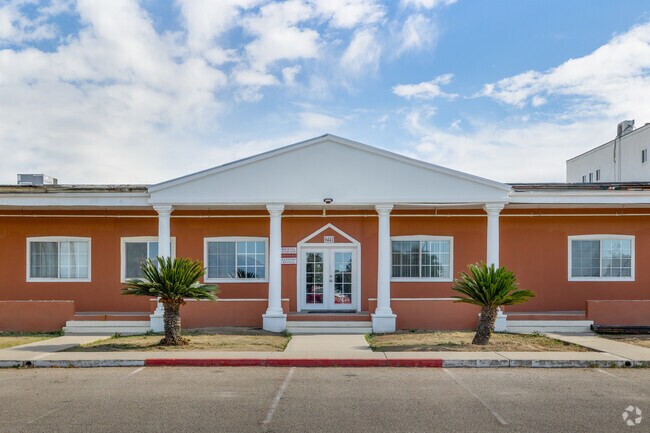
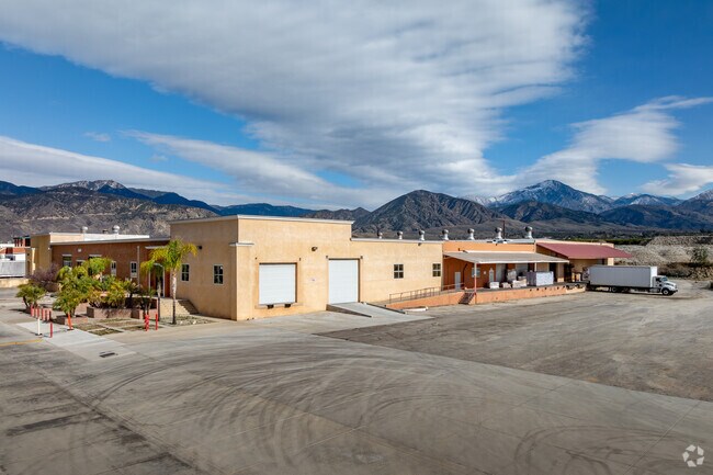
Property Record
9477 Opal Ave, Mentone, CA 92359


Current Lease Availabilities
Property Detail
9477 Opal Ave
Riverside-San Bernardino-Ontario, CA
W 1/2 NE 1/4 SW 1/4 AND PTN NW 1/4 SW 1/4 AND PTN S 1/2 N 1/2 SEC 18 TP 1S R 2W BEING IN MAP OF MENTONE LOTS 3 AND 10 AND PTN LOTS 2 AND 11 BLK 4 AND S 221.83 FT LOTS 3 AND 4 BLK 14 LYING E OF E LI AT AND SF RR R/W TOGETHER WITH BADEN AVE VAC EX THER
0297-122-15
San Bernardino
Shipyard
California
IR
3
2025
32.81 AC
2025
Redlands/Loma Linda
008602
Inland Empire (California)
182,475 SF
NEARBY LISTINGS FOR SALE OR LEASE
DEMOGRAPHICS near 9477 Opal Ave
1 mile
3 mile
5 mile
2025 Total Population
4,055
51,460
119,013
2030 Population
4,029
51,960
120,464
Pop Growth 2025-2030
(0.64%)
+ 0.97%
+ 1.22%
Average Age
37
38
39
2025 Total Households
1,371
16,910
41,199
HH Growth 2025-2030
(0.73%)
+ 1.05%
+ 1.30%
Median Household Inc
$92,528
$103,943
$107,141
Avg Household Size
2.90
2.90
2.80
2025 Avg HH Vehicles
2.00
2.00
2.00
Median Home Value
$497,357
$586,268
$638,401
Median Year Built
1983
1982
1981
Nearby Places
Map Layers
Map Styles
 Street
 Aerial
Layers
 Traffic
 Biking
Places
Listings with unknown addresses are not visible on the map
- Restaurants
- Banks
- Shops
- Fitness
- Groceries
PUBLIC TRANSPORTATION
COMMUTER RAIL
Redlands - University Metrolink Station (Metrolink San Bernardino Line - Metrolink Trains)
Drive
Walk
Distance
Redlands - University Metrolink Station (Metrolink San Bernardino Line - Metrolink Trains)
10 min
4.1 mi
Redlands - Downtown Metrolink Station (Metrolink San Bernardino Line - Metrolink Trains)
Drive
Walk
Distance
Redlands - Downtown Metrolink Station (Metrolink San Bernardino Line - Metrolink Trains)
11 min
4.6 mi
AIRPORT
Ontario International
Drive
Walk
Distance
Ontario International
41 min
29.1 mi
Freight Ports
Port of Long Beach
Drive
Walk
Distance
Port of Long Beach
98 min
74.4 mi
Nearby Properties
Address
Land Use
TOTAL SIZE
Lot Size
Zoning
Address
Land Use
TOTAL SIZE
Lot Size
Zoning
56.83 AC
Address
Land Use
TOTAL SIZE
Lot Size
Zoning
166,788 SF
11.74 AC
Address
Land Use
TOTAL SIZE
Lot Size
Zoning
169,312 SF
10.99 AC
Address
Land Use
TOTAL SIZE
Lot Size
Zoning
82,356 SF
5.10 AC
RM
Address
Land Use
TOTAL SIZE
Lot Size
Zoning
104,067 SF
Address
Land Use
TOTAL SIZE
Lot Size
Zoning
123,230 SF
6.33 AC
CGSCP
Address
Land Use
TOTAL SIZE
Lot Size
Zoning
37.87 AC
RS
Address
Land Use
TOTAL SIZE
Lot Size
Zoning
31.34 AC
Address
Land Use
TOTAL SIZE
Lot Size
Zoning
17,278 SF
5.08 AC
Address
Land Use
TOTAL SIZE
Lot Size
Zoning
2,527 SF
35.13 AC
IC
Address
Land Use
TOTAL SIZE
Lot Size
Zoning
39,424 SF
3.07 AC
Z2
Address
Land Use
TOTAL SIZE
Lot Size
Zoning
47,280 SF
3.45 AC
Address
Land Use
TOTAL SIZE
Lot Size
Zoning
36,892 SF
2.30 AC
RM
Address
Land Use
TOTAL SIZE
Lot Size
Zoning
62,115 SF
13.20 AC
Address
Land Use
TOTAL SIZE
Lot Size
Zoning
44,307 SF
3.71 AC
Address
Land Use
TOTAL SIZE
Lot Size
Zoning
63,917 SF
6.61 AC
Address
Land Use
TOTAL SIZE
Lot Size
Zoning
43,250 SF
6.70 AC
Address
Land Use
TOTAL SIZE
Lot Size
Zoning
45,565 SF
4.48 AC
Address
Land Use
TOTAL SIZE
Lot Size
Zoning
16,455 SF
1.56 AC
Address
Land Use
TOTAL SIZE
Lot Size
Zoning
34.60 AC
Address
Land Use
TOTAL SIZE
Lot Size
Zoning
11,001 SF
1.08 AC
Address
Land Use
TOTAL SIZE
Lot Size
Zoning
44,294 SF
2.27 AC
IC
Address
Land Use
TOTAL SIZE
Lot Size
Zoning
28,800 SF
2 AC
R2
Address
Land Use
TOTAL SIZE
Lot Size
Zoning
7,098 SF
1.28 AC
Address
Land Use
TOTAL SIZE
Lot Size
Zoning
167,130 SF
7.80 AC
Address
Land Use
TOTAL SIZE
Lot Size
Zoning
75,696 SF
3.53 AC
CGSCP
Address
Land Use
TOTAL SIZE
Lot Size
Zoning
34,342 SF
3.26 AC
Address
Land Use
TOTAL SIZE
Lot Size
Zoning
68,800 SF
61.63 AC
AGAP
Address
Land Use
TOTAL SIZE
Lot Size
Zoning
40,428 SF
1.08 AC
Address
Land Use
TOTAL SIZE
Lot Size
Zoning
14,820 SF
1.72 AC
The World's #1 Commercial Real Estate Marketplace
Connect with us
© 2026 CoStar Group
The information above has been obtained from sources believed reliable. While we do not doubt its accuracy we have not verified it and make no guarantee, warranty or representation about it. It is your responsibility to independently confirm its accuracy and completeness. Any projections, opinions, assumptions, or estimates used are for example only and do not represent the current or future performance of the property. The value of this transaction to you depends on tax and other factors which should be evaluated by your tax, financial, and legal advisors. You and your advisors should conduct a careful, independent investigation of the property to determine to your satisfaction the suitability of the property for your needs.