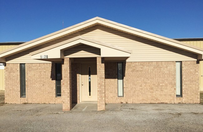
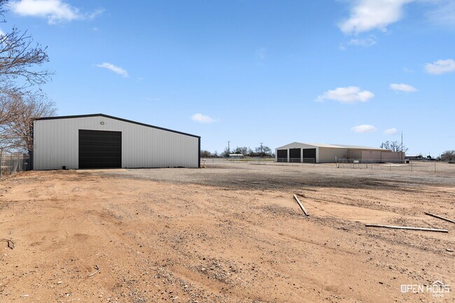
Property Record
9478 Seymour Hwy, Wichita Falls, TX 76310

Save to a Folder
{{folder.Name}}
{{folder.ListingIds.length}} Properties
{{folder.ListingIds.length}} Property
Create a New Folder
This Property Is For Sale
Property Detail
9478 Seymour Hwy
153752
2.8553 AC BLK 12 DENTON CSL LG 4
Commercialnec
Wichita
B and X Area of moderate flood hazard, usually the area between the limits of the 100-year and 500-year floods.
Texas
2025
2.86 AC
2025
Wichita Falls
012800
Other Market Areas
14,332 SF
Wichita Falls, TX
NEARBY LISTINGS FOR SALE OR LEASE
DEMOGRAPHICS near 9478 Seymour Hwy
1 mile
3 mile
5 mile
2025 Total Population
84
1,469
9,838
2030 Population
84
1,501
9,927
Pop Growth 2025-2030
0.00%
+ 2.18%
+ 0.90%
Average Age
42
42
40
2025 Total Households
30
554
3,759
HH Growth 2025-2030
0.00%
+ 2.17%
+ 0.69%
Median Household Inc
$121,874
$86,830
$92,504
Avg Household Size
2.70
2.60
2.60
2025 Avg HH Vehicles
2.00
2.00
2.00
Median Home Value
$260,714
$217,466
$244,532
Median Year Built
1977
1975
1985
Nearby Places
Map Layers
Map Styles
 Street
 Aerial
Layers
 Traffic
 Biking
Places
Listings with unknown addresses are not visible on the map
- Restaurants
- Banks
- Shops
- Fitness
- Groceries
Nearby Properties
Address
Land Use
TOTAL SIZE
Lot Size
Zoning
Address
Land Use
TOTAL SIZE
Lot Size
Zoning
645,164 SF
10 AC
Address
Land Use
TOTAL SIZE
Lot Size
Zoning
532 SF
365.08 AC
Address
Land Use
TOTAL SIZE
Lot Size
Zoning
5,426 SF
534.01 AC
Address
Land Use
TOTAL SIZE
Lot Size
Zoning
22,310 SF
7.67 AC
Address
Land Use
TOTAL SIZE
Lot Size
Zoning
7,200 SF
0.16 AC
Address
Land Use
TOTAL SIZE
Lot Size
Zoning
7,200 SF
0.16 AC
Address
Land Use
TOTAL SIZE
Lot Size
Zoning
9,100 SF
1.44 AC
8475212943
Address
Land Use
TOTAL SIZE
Lot Size
Zoning
17,214 SF
0.13 AC
Address
Land Use
TOTAL SIZE
Lot Size
Zoning
4,785 SF
6.50 AC
Address
Land Use
TOTAL SIZE
Lot Size
Zoning
5,732 SF
8 AC
Address
Land Use
TOTAL SIZE
Lot Size
Zoning
32,352 SF
6.49 AC
Address
Land Use
TOTAL SIZE
Lot Size
Zoning
9,300 SF
79.66 AC
Address
Land Use
TOTAL SIZE
Lot Size
Zoning
9,511 SF
39.56 AC
Address
Land Use
TOTAL SIZE
Lot Size
Zoning
7,923 SF
8.20 AC
Address
Land Use
TOTAL SIZE
Lot Size
Zoning
4,545 SF
16 AC
Address
Land Use
TOTAL SIZE
Lot Size
Zoning
7,668 SF
0.63 AC
Address
Land Use
TOTAL SIZE
Lot Size
Zoning
2,256 SF
127.01 AC
Address
Land Use
TOTAL SIZE
Lot Size
Zoning
15,000 SF
6.12 AC
Address
Land Use
TOTAL SIZE
Lot Size
Zoning
12,000 SF
8 AC
Address
Land Use
TOTAL SIZE
Lot Size
Zoning
10,248 SF
5.80 AC
Address
Land Use
TOTAL SIZE
Lot Size
Zoning
6,520 SF
7.67 AC
Address
Land Use
TOTAL SIZE
Lot Size
Zoning
4,456 SF
7.80 AC
Address
Land Use
TOTAL SIZE
Lot Size
Zoning
12,569 SF
20 AC
Address
Land Use
TOTAL SIZE
Lot Size
Zoning
3,100 SF
15 AC
Address
Land Use
TOTAL SIZE
Lot Size
Zoning
5,179 SF
5 AC
MT
Address
Land Use
TOTAL SIZE
Lot Size
Zoning
2,776 SF
0.20 AC
Address
Land Use
TOTAL SIZE
Lot Size
Zoning
12,315 SF
5.26 AC
Address
Land Use
TOTAL SIZE
Lot Size
Zoning
10,761 SF
0.94 AC
Address
Land Use
TOTAL SIZE
Lot Size
Zoning
12,200 SF
5 AC
The World's #1 Commercial Real Estate Marketplace
Connect with us
© 2026 CoStar Group
The information above has been obtained from sources believed reliable. While we do not doubt its accuracy we have not verified it and make no guarantee, warranty or representation about it. It is your responsibility to independently confirm its accuracy and completeness. Any projections, opinions, assumptions, or estimates used are for example only and do not represent the current or future performance of the property. The value of this transaction to you depends on tax and other factors which should be evaluated by your tax, financial, and legal advisors. You and your advisors should conduct a careful, independent investigation of the property to determine to your satisfaction the suitability of the property for your needs.