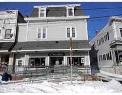
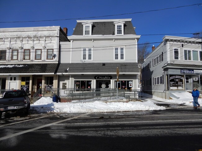
Property Record
948 Main St, Warren, MA 01083

Property Detail
948 Main St
WARR-000024-000000-000005
Worcester
Restaurantbuilding
Massachusetts
VIL
5
2025
0.19 AC
2025
Outlying Worcester
761100
Boston
8,817 SF
Worcester, MA
NEARBY LISTINGS FOR SALE OR LEASE
-
-
View all Warren listings for sale on LoopNet.com
DEMOGRAPHICS near 948 Main St
1 mile
3 mile
5 mile
2025 Total Population
2,294
6,674
19,407
2030 Population
2,399
6,892
19,776
Pop Growth 2025-2030
+ 4.58%
+ 3.27%
+ 1.90%
Average Age
42
44
43
2025 Total Households
953
2,747
8,043
HH Growth 2025-2030
+ 4.72%
+ 3.31%
+ 1.98%
Median Household Inc
$44,817
$64,990
$67,941
Avg Household Size
2.40
2.40
2.40
2025 Avg HH Vehicles
2.00
2.00
2.00
Median Home Value
$426,282
$383,300
$341,227
Median Year Built
1970
1971
1971
Nearby Places
Map Layers
Map Styles
 Street
 Aerial
Layers
 Traffic
 Biking
Places
Listings with unknown addresses are not visible on the map
- Restaurants
- Banks
- Shops
- Fitness
- Groceries
PUBLIC TRANSPORTATION
AIRPORT
Worcester Regional
Drive
Walk
Distance
Worcester Regional
46 min
22.8 mi
Bradley International
Drive
Walk
Distance
Bradley International
67 min
40.0 mi
Freight Ports
Port of Davisville, RI
Drive
Walk
Distance
Port of Davisville, RI
115 min
83.0 mi
SALE & LEASE HISTORY
LISTING DATE
SALE/LEASE

Feb 01, 2019
For Sale
Nearby Properties
Address
Land Use
TOTAL SIZE
Lot Size
Zoning
Address
Land Use
TOTAL SIZE
Lot Size
Zoning
97,336 SF
25.28 AC
RUR
Address
Land Use
TOTAL SIZE
Lot Size
Zoning
96,983 SF
60 AC
VIL
Address
Land Use
TOTAL SIZE
Lot Size
Zoning
236,071 SF
35.57 AC
VIL
Address
Land Use
TOTAL SIZE
Lot Size
Zoning
10.90 AC
VIL
Address
Land Use
TOTAL SIZE
Lot Size
Zoning
20,280 SF
5.83 AC
RUR
Address
Land Use
TOTAL SIZE
Lot Size
Zoning
18,744 SF
5.80 AC
GD
Address
Land Use
TOTAL SIZE
Lot Size
Zoning
1,989 SF
4.06 AC
GD
Address
Land Use
TOTAL SIZE
Lot Size
Zoning
42,853 SF
0.64 AC
GD
Address
Land Use
TOTAL SIZE
Lot Size
Zoning
3,161 SF
1 AC
GD
Address
Land Use
TOTAL SIZE
Lot Size
Zoning
14,500 SF
0.34 AC
VIL
Address
Land Use
TOTAL SIZE
Lot Size
Zoning
424,963 SF
65.60 AC
COM
Address
Land Use
TOTAL SIZE
Lot Size
Zoning
57,094 SF
4.68 AC
GD
Address
Land Use
TOTAL SIZE
Lot Size
Zoning
3.77 AC
VIL
Address
Land Use
TOTAL SIZE
Lot Size
Zoning
9,836 SF
105.68 AC
RR
Address
Land Use
TOTAL SIZE
Lot Size
Zoning
9,836 SF
0.73 AC
GD
Address
Land Use
TOTAL SIZE
Lot Size
Zoning
0.62 AC
VIL
Address
Land Use
TOTAL SIZE
Lot Size
Zoning
9,400 SF
1.40 AC
VIL
Address
Land Use
TOTAL SIZE
Lot Size
Zoning
351.25 AC
RR
Address
Land Use
TOTAL SIZE
Lot Size
Zoning
10,080 SF
0.47 AC
VIL
Address
Land Use
TOTAL SIZE
Lot Size
Zoning
0.21 AC
GD
Address
Land Use
TOTAL SIZE
Lot Size
Zoning
41,400 SF
3.65 AC
GD
Address
Land Use
TOTAL SIZE
Lot Size
Zoning
6.60 AC
VIL
Address
Land Use
TOTAL SIZE
Lot Size
Zoning
6,266 SF
9.60 AC
RUR
Address
Land Use
TOTAL SIZE
Lot Size
Zoning
0.59 AC
VIL
Address
Land Use
TOTAL SIZE
Lot Size
Zoning
4,137 SF
28 AC
RUR
Address
Land Use
TOTAL SIZE
Lot Size
Zoning
1.30 AC
RUR
Address
Land Use
TOTAL SIZE
Lot Size
Zoning
60.49 AC
VIL
Address
Land Use
TOTAL SIZE
Lot Size
Zoning
1.30 AC
VIL
Address
Land Use
TOTAL SIZE
Lot Size
Zoning
6,780 SF
7.40 AC
GD
Address
Land Use
TOTAL SIZE
Lot Size
Zoning
4,568 SF
2.25 AC
GD
The World's #1 Commercial Real Estate Marketplace
Connect with us
© 2026 CoStar Group
The information above has been obtained from sources believed reliable. While we do not doubt its accuracy we have not verified it and make no guarantee, warranty or representation about it. It is your responsibility to independently confirm its accuracy and completeness. Any projections, opinions, assumptions, or estimates used are for example only and do not represent the current or future performance of the property. The value of this transaction to you depends on tax and other factors which should be evaluated by your tax, financial, and legal advisors. You and your advisors should conduct a careful, independent investigation of the property to determine to your satisfaction the suitability of the property for your needs.