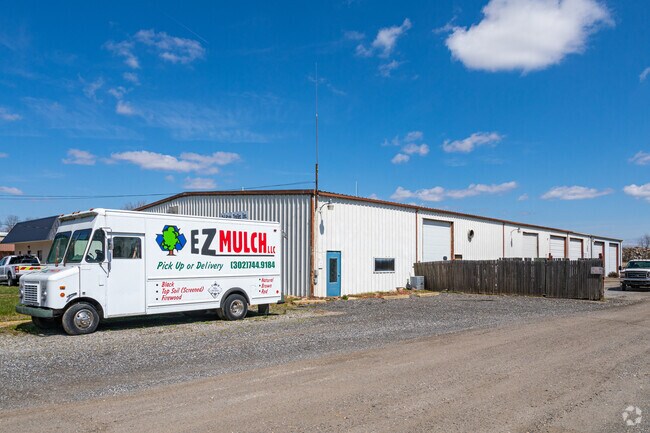
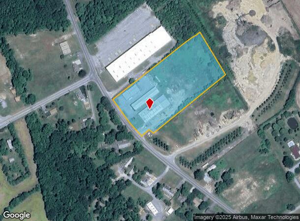
Property Record
949 Horsepond Rd, Dover, DE 19901
NEARBY LISTINGS FOR SALE OR LEASE
Property Detail
949 Horsepond Rd
2-00-07800-01-2400-000
Taylor Estate Between Camden And Dover
Commercialnec
25FT LOT 20
X
Kent
10001C0188J
Delaware
2025
4.96 AC
2025
Kent County
041000
Philadelphia
7,600 SF
Dover, DE
DEMOGRAPHICS near 949 Horsepond Rd
1 Mile
3 Mile
5 Mile
2024 Total Population
1,640
31,106
68,213
2029 Population
1,745
33,332
73,135
Pop Growth 2024-2029
+ 6.40%
+ 7.16%
+ 7.22%
Average Age
36
37
38
2024 Total Households
706
12,378
26,011
HH Growth 2024-2029
+ 6.66%
+ 7.39%
+ 7.50%
Median Household Inc
$51,630
$52,625
$59,582
Avg Household Size
2.30
2.40
2.50
2024 Avg HH Vehicles
1.00
2.00
2.00
Median Home Value
$80,424
$225,000
$259,397
Median Year Built
1979
1979
1986
Nearby Places
Map Layers
Map Styles
 Street
 Aerial
- Restaurants
- Banks
- Shops
- Fitness
- Groceries
Nearby Properties
Address
Land Use
TOTAL SIZE
Lot Size
Zoning
Address
Land Use
TOTAL SIZE
Lot Size
Zoning
136,308 SF
2,301.50 AC
R20
Address
Land Use
TOTAL SIZE
Lot Size
Zoning
Address
Land Use
TOTAL SIZE
Lot Size
Zoning
189,363 SF
123.90 AC
IO
Address
Land Use
TOTAL SIZE
Lot Size
Zoning
172,440 SF
28.86 AC
RM2
Address
Land Use
TOTAL SIZE
Lot Size
Zoning
322,096 SF
18.20 AC
SC2
Address
Land Use
TOTAL SIZE
Lot Size
Zoning
129,471 SF
TND
Address
Land Use
TOTAL SIZE
Lot Size
Zoning
108,450 SF
11 AC
RM
Address
Land Use
TOTAL SIZE
Lot Size
Zoning
116,604 SF
3.20 AC
IO
Address
Land Use
TOTAL SIZE
Lot Size
Zoning
187,104 SF
7.80 AC
RM1
Address
Land Use
TOTAL SIZE
Lot Size
Zoning
72,794 SF
11.57 AC
IO
Address
Land Use
TOTAL SIZE
Lot Size
Zoning
Address
Land Use
TOTAL SIZE
Lot Size
Zoning
Address
Land Use
TOTAL SIZE
Lot Size
Zoning
434.50 AC
DAFB
Address
Land Use
TOTAL SIZE
Lot Size
Zoning
243,410 SF
43.20 AC
IPM
Address
Land Use
TOTAL SIZE
Lot Size
Zoning
111,744 SF
11.47 AC
RG2
Address
Land Use
TOTAL SIZE
Lot Size
Zoning
113,226 SF
2.50 AC
IO
Address
Land Use
TOTAL SIZE
Lot Size
Zoning
105,470 SF
6.90 AC
IO
Address
Land Use
TOTAL SIZE
Lot Size
Zoning
168,550 SF
22.40 AC
IO
Address
Land Use
TOTAL SIZE
Lot Size
Zoning
Address
Land Use
TOTAL SIZE
Lot Size
Zoning
55,272 SF
11.30 AC
IO
Address
Land Use
TOTAL SIZE
Lot Size
Zoning
Address
Land Use
TOTAL SIZE
Lot Size
Zoning
79,447 SF
3.18 AC
C4
Address
Land Use
TOTAL SIZE
Lot Size
Zoning
74,521 SF
15.90 AC
IO
Address
Land Use
TOTAL SIZE
Lot Size
Zoning
97,489 SF
8.69 AC
SC2
Address
Land Use
TOTAL SIZE
Lot Size
Zoning
23,122 SF
8.90 AC
SC1
Address
Land Use
TOTAL SIZE
Lot Size
Zoning
3,208 SF
1,510.50 AC
AC
Address
Land Use
TOTAL SIZE
Lot Size
Zoning
68,076 SF
2.63 AC
TND
Address
Land Use
TOTAL SIZE
Lot Size
Zoning
126,854 SF
10.90 AC
C4
Address
Land Use
TOTAL SIZE
Lot Size
Zoning
93,954 SF
2.80 AC
IO
Address
Land Use
TOTAL SIZE
Lot Size
Zoning
86,569 SF
5 AC
IO
The World's #1 Commercial Real Estate Marketplace
Connect with us
© 2025 CoStar Group
The information above has been obtained from sources believed reliable. While we do not doubt its accuracy we have not verified it and make no guarantee, warranty or representation about it. It is your responsibility to independently confirm its accuracy and completeness. Any projections, opinions, assumptions, or estimates used are for example only and do not represent the current or future performance of the property. The value of this transaction to you depends on tax and other factors which should be evaluated by your tax, financial, and legal advisors. You and your advisors should conduct a careful, independent investigation of the property to determine to your satisfaction the suitability of the property for your needs.