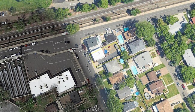
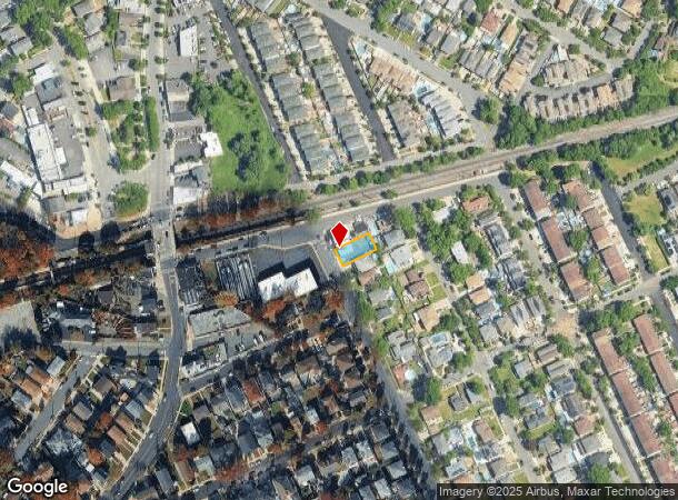
Property Record
95 Barclay Ave, Staten Island, NY 10312
NEARBY LISTINGS FOR SALE OR LEASE
Property Detail
95 Barclay Ave
06217-0019
Staten Island
Commercialofficeresidentialmixeduse
New York
X
19
3604970316F
0.12 AC
2024
Staten Island
2025
Long Island (New York)
017005
New York-Jersey City-White Plains, NY-NJ
2,300 SF
DEMOGRAPHICS near 95 Barclay Ave
1 Mile
3 Mile
5 Mile
2024 Total Population
28,862
135,326
275,361
2029 Population
28,213
133,110
270,694
Pop Growth 2024-2029
(2.25%)
(1.64%)
(1.69%)
Average Age
43
42
42
2024 Total Households
10,446
48,954
96,939
HH Growth 2024-2029
(2.37%)
(1.71%)
(1.77%)
Median Household Inc
$118,217
$104,437
$95,034
Avg Household Size
2.70
2.70
2.80
2024 Avg HH Vehicles
2.00
2.00
2.00
Median Home Value
$731,644
$672,193
$653,047
Median Year Built
1977
1980
1977
Nearby Places
Map Layers
Map Styles
 Street
 Aerial
- Restaurants
- Banks
- Shops
- Fitness
- Groceries
PUBLIC TRANSPORTATION
TRANSIT/SUBWAY
Annadale (Staten Island Railway - New York MTA Subway (The Subway))
DRIVE
WALK
Distance
Annadale (Staten Island Railway - New York MTA Subway (The Subway))
1 min
3 min
0.2 mi
Eltingville (Staten Island Railway - New York MTA Subway (The Subway))
DRIVE
WALK
Distance
Eltingville (Staten Island Railway - New York MTA Subway (The Subway))
3 min
16 min
0.8 mi
COMMUTER RAIL
Annadale (Staten Island Railway - New York MTA Subway (The Subway))
DRIVE
WALK
Distance
Annadale (Staten Island Railway - New York MTA Subway (The Subway))
1 min
3 min
0.2 mi
Eltingville (Staten Island Railway - New York MTA Subway (The Subway))
DRIVE
WALK
Distance
Eltingville (Staten Island Railway - New York MTA Subway (The Subway))
3 min
15 min
0.8 mi
AIRPORT
Newark Liberty International
DRIVE
WALK
Distance
Newark Liberty International
31 min
17.5 mi
LaGuardia
DRIVE
WALK
Distance
LaGuardia
51 min
28.2 mi
John F Kennedy International
DRIVE
WALK
Distance
John F Kennedy International
50 min
30.9 mi
Freight Ports
New York Container Terminal
DRIVE
WALK
Distance
New York Container Terminal
17 min
8.5 mi
SALE & LEASE HISTORY
LISTING DATE
SALE/LEASE

Oct 10, 2023
For Lease
Nearby Properties
Address
Land Use
TOTAL SIZE
Lot Size
Zoning
Address
Land Use
TOTAL SIZE
Lot Size
Zoning
3,600 SF
731.18 AC
PARK
Address
Land Use
TOTAL SIZE
Lot Size
Zoning
794,430 SF
36.09 AC
R50
Address
Land Use
TOTAL SIZE
Lot Size
Zoning
237 AC
M1-1
Address
Land Use
TOTAL SIZE
Lot Size
Zoning
118 AC
M3-1
Address
Land Use
TOTAL SIZE
Lot Size
Zoning
1,258,042 SF
14.47 AC
C4-1
Address
Land Use
TOTAL SIZE
Lot Size
Zoning
196,382 SF
25.95 AC
Address
Land Use
TOTAL SIZE
Lot Size
Zoning
146 AC
PARK
Address
Land Use
TOTAL SIZE
Lot Size
Zoning
286,290 SF
21.24 AC
R50
Address
Land Use
TOTAL SIZE
Lot Size
Zoning
411,000 SF
18.54 AC
R3X
Address
Land Use
TOTAL SIZE
Lot Size
Zoning
55.47 AC
Address
Land Use
TOTAL SIZE
Lot Size
Zoning
5,214 SF
93 AC
M3-1
Address
Land Use
TOTAL SIZE
Lot Size
Zoning
214,392 SF
11.79 AC
R50
Address
Land Use
TOTAL SIZE
Lot Size
Zoning
195,395 SF
12.04 AC
R3-2
Address
Land Use
TOTAL SIZE
Lot Size
Zoning
11,140 SF
170.60 AC
PARK
Address
Land Use
TOTAL SIZE
Lot Size
Zoning
220,240 SF
5.77 AC
R3X
Address
Land Use
TOTAL SIZE
Lot Size
Zoning
38.58 AC
PARK
Address
Land Use
TOTAL SIZE
Lot Size
Zoning
505,000 SF
3.79 AC
R3A
Address
Land Use
TOTAL SIZE
Lot Size
Zoning
75,592 SF
9.86 AC
R50
Address
Land Use
TOTAL SIZE
Lot Size
Zoning
33.36 AC
PARK
Address
Land Use
TOTAL SIZE
Lot Size
Zoning
377,678 SF
25.40 AC
C4-1
Address
Land Use
TOTAL SIZE
Lot Size
Zoning
28.97 AC
PARK
Address
Land Use
TOTAL SIZE
Lot Size
Zoning
26.08 AC
PARK
Address
Land Use
TOTAL SIZE
Lot Size
Zoning
180,000 SF
91.83 AC
M3-1
Address
Land Use
TOTAL SIZE
Lot Size
Zoning
192,000 SF
5.47 AC
R3X
Address
Land Use
TOTAL SIZE
Lot Size
Zoning
188,692 SF
9.66 AC
R3-2
Address
Land Use
TOTAL SIZE
Lot Size
Zoning
26.45 AC
PARK
Address
Land Use
TOTAL SIZE
Lot Size
Zoning
80,875 SF
283.97 AC
M3-1
Address
Land Use
TOTAL SIZE
Lot Size
Zoning
109,000 SF
3.38 AC
R3X
Address
Land Use
TOTAL SIZE
Lot Size
Zoning
27.90 AC
R3X
Address
Land Use
TOTAL SIZE
Lot Size
Zoning
386,608 SF
69.19 AC
M3-1
The World's #1 Commercial Real Estate Marketplace
Connect with us
© 2025 CoStar Group
The information above has been obtained from sources believed reliable. While we do not doubt its accuracy we have not verified it and make no guarantee, warranty or representation about it. It is your responsibility to independently confirm its accuracy and completeness. Any projections, opinions, assumptions, or estimates used are for example only and do not represent the current or future performance of the property. The value of this transaction to you depends on tax and other factors which should be evaluated by your tax, financial, and legal advisors. You and your advisors should conduct a careful, independent investigation of the property to determine to your satisfaction the suitability of the property for your needs.