Property Record
95 Haverhill Rd, Amesbury, MA 01913

Property Detail
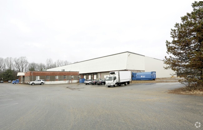
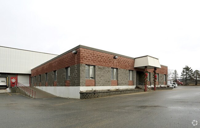
95 Haverhill Rd
Warehouse
Essex
I
Massachusetts
AE The base floodplain where base flood elevations are provided. AE Zones are now used on new format FIRMs instead of A1-A30 Zones.
23.60 AC
2025
Amesbury/Ipswich
2025
Boston
266100
Boston-Cambridge-Newton, MA-NH
77,498 SF
AMES-000085-000000-000013
NEARBY LISTINGS FOR SALE OR LEASE
DEMOGRAPHICS near 95 Haverhill Rd
1 mile
3 mile
5 mile
2025 Total Population
3,027
27,989
55,938
2030 Population
3,097
28,757
57,531
Pop Growth 2025-2030
+ 2.31%
+ 2.74%
+ 2.85%
Average Age
42
44
44
2025 Total Households
1,224
11,599
22,729
HH Growth 2025-2030
+ 2.21%
+ 2.69%
+ 2.82%
Median Household Inc
$103,356
$105,622
$115,673
Avg Household Size
2.40
2.30
2.40
2025 Avg HH Vehicles
2.00
2.00
2.00
Median Home Value
$556,180
$607,659
$648,552
Median Year Built
1985
1973
1974
Nearby Places
Map Layers
Map Styles
 Street
 Aerial
Layers
 Traffic
 Biking
Places
Listings with unknown addresses are not visible on the map
- Restaurants
- Banks
- Shops
- Fitness
- Groceries
PUBLIC TRANSPORTATION
COMMUTER RAIL
Newburyport (Newburyport/Rockport Line - Massachusetts Bay Transportation Authority Commuter Rail (Purple Line))
Drive
Walk
Distance
Newburyport (Newburyport/Rockport Line - Massachusetts Bay Transportation Authority Commuter Rail (Purple Line))
17 min
6.8 mi
Haverhill (Haverhill Line - Massachusetts Bay Transportation Authority Commuter Rail (Purple Line))
Drive
Walk
Distance
Haverhill (Haverhill Line - Massachusetts Bay Transportation Authority Commuter Rail (Purple Line))
18 min
10.0 mi
AIRPORT
Portsmouth International at Pease
Drive
Walk
Distance
Portsmouth International at Pease
33 min
21.7 mi
Manchester Boston Regional
Drive
Walk
Distance
Manchester Boston Regional
59 min
39.7 mi
General Edward Lawrence Logan International
Drive
Walk
Distance
General Edward Lawrence Logan International
58 min
40.0 mi
Freight Ports
Port of Boston
Drive
Walk
Distance
Port of Boston
61 min
42.9 mi
Nearby Properties
Address
Land Use
TOTAL SIZE
Lot Size
Zoning
Address
Land Use
TOTAL SIZE
Lot Size
Zoning
26.44 AC
OP
Address
Land Use
TOTAL SIZE
Lot Size
Zoning
176,157 SF
25.53 AC
OSC
Address
Land Use
TOTAL SIZE
Lot Size
Zoning
2,362 SF
342.02 AC
Address
Land Use
TOTAL SIZE
Lot Size
Zoning
145,676 SF
17.42 AC
OSC
Address
Land Use
TOTAL SIZE
Lot Size
Zoning
9.31 AC
R8
Address
Land Use
TOTAL SIZE
Lot Size
Zoning
94,943 SF
15.52 AC
RCZD
Address
Land Use
TOTAL SIZE
Lot Size
Zoning
191,775 SF
23.50 AC
C
Address
Land Use
TOTAL SIZE
Lot Size
Zoning
79,991 SF
2.66 AC
IC
Address
Land Use
TOTAL SIZE
Lot Size
Zoning
2.47 AC
R8
Address
Land Use
TOTAL SIZE
Lot Size
Zoning
4.30 AC
R40
Address
Land Use
TOTAL SIZE
Lot Size
Zoning
3.68 AC
R40
Address
Land Use
TOTAL SIZE
Lot Size
Zoning
106,820 SF
9.97 AC
Address
Land Use
TOTAL SIZE
Lot Size
Zoning
274,050 SF
29.02 AC
I
Address
Land Use
TOTAL SIZE
Lot Size
Zoning
129.11 AC
RC
Address
Land Use
TOTAL SIZE
Lot Size
Zoning
147,462 SF
10.60 AC
I
Address
Land Use
TOTAL SIZE
Lot Size
Zoning
61,320 SF
35.32 AC
OSC
Address
Land Use
TOTAL SIZE
Lot Size
Zoning
74,516 SF
13.40 AC
VR
Address
Land Use
TOTAL SIZE
Lot Size
Zoning
126,144 SF
5.41 AC
I
Address
Land Use
TOTAL SIZE
Lot Size
Zoning
58,391 SF
14.11 AC
OSC
Address
Land Use
TOTAL SIZE
Lot Size
Zoning
5.98 AC
R8
Address
Land Use
TOTAL SIZE
Lot Size
Zoning
14.35 AC
R20
Address
Land Use
TOTAL SIZE
Lot Size
Zoning
424,000 SF
42.54 AC
I
Address
Land Use
TOTAL SIZE
Lot Size
Zoning
37,886 SF
0.78 AC
IC
Address
Land Use
TOTAL SIZE
Lot Size
Zoning
3 AC
OP
Address
Land Use
TOTAL SIZE
Lot Size
Zoning
1.18 AC
R8
Address
Land Use
TOTAL SIZE
Lot Size
Zoning
49.70 AC
I
Address
Land Use
TOTAL SIZE
Lot Size
Zoning
1,983 SF
6.58 AC
R8
Address
Land Use
TOTAL SIZE
Lot Size
Zoning
2.29 AC
R8
Address
Land Use
TOTAL SIZE
Lot Size
Zoning
39,841 SF
3.57 AC
R8
The World's #1 Commercial Real Estate Marketplace
Connect with us
© 2026 CoStar Group
The information above has been obtained from sources believed reliable. While we do not doubt its accuracy we have not verified it and make no guarantee, warranty or representation about it. It is your responsibility to independently confirm its accuracy and completeness. Any projections, opinions, assumptions, or estimates used are for example only and do not represent the current or future performance of the property. The value of this transaction to you depends on tax and other factors which should be evaluated by your tax, financial, and legal advisors. You and your advisors should conduct a careful, independent investigation of the property to determine to your satisfaction the suitability of the property for your needs.