Property Record
95 Hermit Smith Rd, Apopka, FL 32703
Current Lease Availabilities
NEARBY LISTINGS FOR SALE OR LEASE
Property Detail
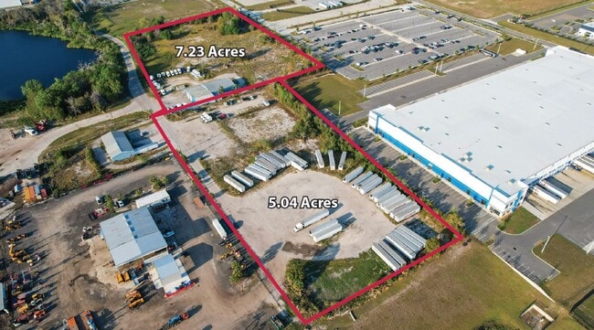
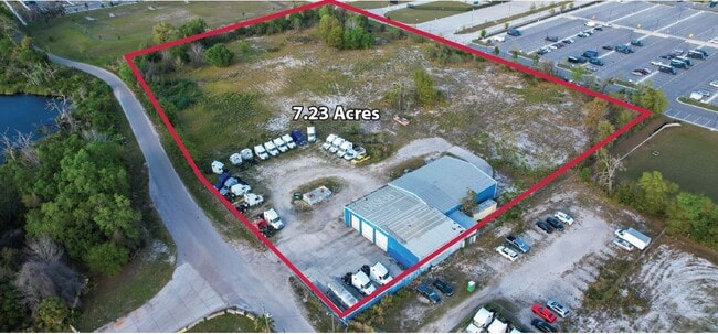
95 Hermit Smith Rd
Orlando-Kissimmee-Sanford, FL
THE W1/2 OF SW1/4 OF SW1/4 OF SE1/4 OF SEC 01-21-27
01-2127-0000-00-081
Orange
Industrialacreage
Florida
X
81
12095C0125H
5.04 AC
2025
NW Orange Outlying
2025
Orlando
017504
DEMOGRAPHICS near 95 Hermit Smith Rd
1 mile
3 mile
5 mile
2024 Total Population
629
27,375
71,014
2029 Population
724
30,188
78,280
Pop Growth 2024-2029
+ 15.10%
+ 10.28%
+ 10.23%
Average Age
39
42
40
2024 Total Households
211
9,815
24,194
HH Growth 2024-2029
+ 15.17%
+ 10.74%
+ 10.66%
Median Household Inc
$66,875
$76,150
$76,890
Avg Household Size
3.00
2.80
2.90
2024 Avg HH Vehicles
2.00
2.00
2.00
Median Home Value
$339,473
$319,680
$313,293
Median Year Built
2008
2001
2000
Nearby Places
Map Layers
Map Styles
 Street
 Aerial
Transit
 Traffic
 Biking
Places
Listings with unknown addresses are not visible on the map
- Restaurants
- Banks
- Shops
- Fitness
- Groceries
PUBLIC TRANSPORTATION
AIRPORT
Orlando Sanford International
Drive
Walk
Distance
Orlando Sanford International
49 min
26.9 mi
Orlando International
Drive
Walk
Distance
Orlando International
48 min
34.6 mi
Freight Ports
Port Canaveral
Drive
Walk
Distance
Port Canaveral
96 min
77.1 mi
Nearby Properties
Address
Land Use
TOTAL SIZE
Lot Size
Zoning
Address
Land Use
TOTAL SIZE
Lot Size
Zoning
1,245,060 SF
90.98 AC
PD
Address
Land Use
TOTAL SIZE
Lot Size
Zoning
1,208,378 SF
57.24 AC
PD
Address
Land Use
TOTAL SIZE
Lot Size
Zoning
467,248 SF
33.67 AC
PD
Address
Land Use
TOTAL SIZE
Lot Size
Zoning
722,019 SF
35.47 AC
PD
Address
Land Use
TOTAL SIZE
Lot Size
Zoning
792,152 SF
53.04 AC
O
Address
Land Use
TOTAL SIZE
Lot Size
Zoning
588,076 SF
38.89 AC
PD
Address
Land Use
TOTAL SIZE
Lot Size
Zoning
537,895 SF
55.19 AC
I-L
Address
Land Use
TOTAL SIZE
Lot Size
Zoning
361,418 SF
18.88 AC
MU-ES-GT
Address
Land Use
TOTAL SIZE
Lot Size
Zoning
343,587 SF
9.67 AC
MU-ES-GT
Address
Land Use
TOTAL SIZE
Lot Size
Zoning
265,125 SF
16.27 AC
MU-ES-GT
Address
Land Use
TOTAL SIZE
Lot Size
Zoning
299,743 SF
PD
Address
Land Use
TOTAL SIZE
Lot Size
Zoning
323,161 SF
43.61 AC
PD
Address
Land Use
TOTAL SIZE
Lot Size
Zoning
347,706 SF
40.19 AC
PD
Address
Land Use
TOTAL SIZE
Lot Size
Zoning
293,305 SF
21.60 AC
PD
Address
Land Use
TOTAL SIZE
Lot Size
Zoning
278,981 SF
51.18 AC
I-L
Address
Land Use
TOTAL SIZE
Lot Size
Zoning
189,514 SF
12.70 AC
MU-ES-GT
Address
Land Use
TOTAL SIZE
Lot Size
Zoning
589,600 SF
19.60 AC
I-L
Address
Land Use
TOTAL SIZE
Lot Size
Zoning
255,880 SF
15.73 AC
PD
Address
Land Use
TOTAL SIZE
Lot Size
Zoning
133,960 SF
17.21 AC
PD
Address
Land Use
TOTAL SIZE
Lot Size
Zoning
685,777 SF
19.32 AC
I-L
Address
Land Use
TOTAL SIZE
Lot Size
Zoning
275,446 SF
12.81 AC
I-L
Address
Land Use
TOTAL SIZE
Lot Size
Zoning
193,525 SF
10.07 AC
D-APK-I-L
Address
Land Use
TOTAL SIZE
Lot Size
Zoning
503,677 SF
27.63 AC
I-L
Address
Land Use
TOTAL SIZE
Lot Size
Zoning
184,786 SF
16.44 AC
I-L
Address
Land Use
TOTAL SIZE
Lot Size
Zoning
75.90 AC
MU-KPI
Address
Land Use
TOTAL SIZE
Lot Size
Zoning
3,688 SF
71.90 AC
MU-KPI
Address
Land Use
TOTAL SIZE
Lot Size
Zoning
406,432 SF
11.62 AC
I-L
Address
Land Use
TOTAL SIZE
Lot Size
Zoning
144,713 SF
9.92 AC
D-APK-I-L
Address
Land Use
TOTAL SIZE
Lot Size
Zoning
152,805 SF
8.85 AC
I-L
Address
Land Use
TOTAL SIZE
Lot Size
Zoning
121,241 SF
8.27 AC
D-APK-I-L
The World's #1 Commercial Real Estate Marketplace
Connect with us
© 2026 CoStar Group
The information above has been obtained from sources believed reliable. While we do not doubt its accuracy we have not verified it and make no guarantee, warranty or representation about it. It is your responsibility to independently confirm its accuracy and completeness. Any projections, opinions, assumptions, or estimates used are for example only and do not represent the current or future performance of the property. The value of this transaction to you depends on tax and other factors which should be evaluated by your tax, financial, and legal advisors. You and your advisors should conduct a careful, independent investigation of the property to determine to your satisfaction the suitability of the property for your needs.