Property Record
95 N Lasa Commons Cir, Saint Augustine, FL 32084

Save to a Folder
{{folder.Name}}
{{folder.ListingIds.length}} Properties
{{folder.ListingIds.length}} Property
Create a New Folder
Property Detail
95 N Lasa Commons Cir
084561-0000
1-1 PT GLS 1 & 6 SEC 1 PT SEC 49 & 50 PT SEC 60-07-30 & N975 FT LOT 55-E ROBINSON GRANT SUB ALL LYING W OF US 1 & E OF FEC R/W (EX OR954/273 & OUT PARCEL B OR954/277) (EX 50 X 50FT TO CITY IN OR1554/939) (EX PT OF RD TO SJC IN OR3112/1038) (EX PT IN
Apartmenthouse5plusunits
ST. JOHNS
CG
Florida
B and X Area of moderate flood hazard, usually the area between the limits of the 100-year and 500-year floods.
55-e
2025
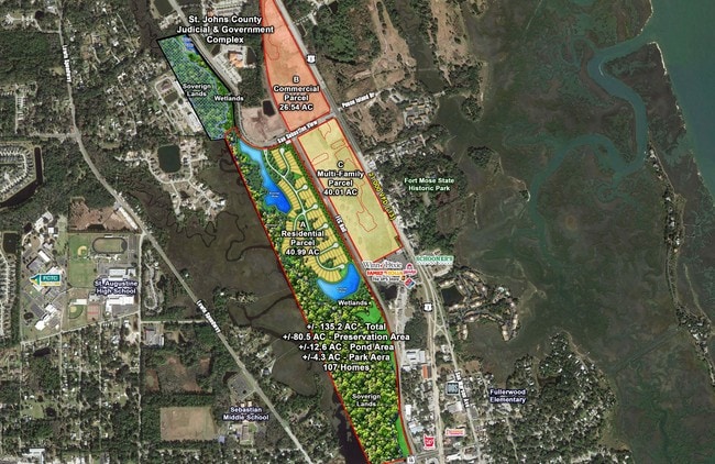
19.29 AC
2026
St Johns County
020300
Jacksonville (Florida)
312,840 SF
Jacksonville, FL
NEARBY LISTINGS FOR SALE OR LEASE
DEMOGRAPHICS near 95 N Lasa Commons Cir
1 mile
3 mile
5 mile
2025 Total Population
4,689
27,999
53,233
2030 Population
5,493
32,642
62,187
Pop Growth 2025-2030
+ 17.15%
+ 16.58%
+ 16.82%
Average Age
44
45
45
2025 Total Households
2,072
12,005
22,804
HH Growth 2025-2030
+ 17.47%
+ 17.06%
+ 17.28%
Median Household Inc
$75,970
$85,350
$82,821
Avg Household Size
2.20
2.20
2.20
2025 Avg HH Vehicles
2.00
2.00
2.00
Median Home Value
$453,956
$454,473
$429,198
Median Year Built
2006
2000
2000
Nearby Places
Map Layers
Map Styles
 Street
 Aerial
Layers
 Traffic
 Biking
Places
Listings with unknown addresses are not visible on the map
- Restaurants
- Banks
- Shops
- Fitness
- Groceries
SALE & LEASE HISTORY
LISTING DATE
SALE/LEASE

Sep 24, 2016
For Sale
Jan 13, 2017
For Sale
Nearby Properties
Address
Land Use
TOTAL SIZE
Lot Size
Zoning
Address
Land Use
TOTAL SIZE
Lot Size
Zoning
322,553 SF
10.54 AC
Address
Land Use
TOTAL SIZE
Lot Size
Zoning
198,608 SF
54.13 AC
AD
Address
Land Use
TOTAL SIZE
Lot Size
Zoning
323,748 SF
4.62 AC
Address
Land Use
TOTAL SIZE
Lot Size
Zoning
657,013 SF
77.07 AC
Address
Land Use
TOTAL SIZE
Lot Size
Zoning
274,007 SF
22.11 AC
Address
Land Use
TOTAL SIZE
Lot Size
Zoning
343,365 SF
127.66 AC
Address
Land Use
TOTAL SIZE
Lot Size
Zoning
422,807 SF
80.60 AC
OR
Address
Land Use
TOTAL SIZE
Lot Size
Zoning
250,683 SF
41.99 AC
PS
Address
Land Use
TOTAL SIZE
Lot Size
Zoning
325,487 SF
19.20 AC
PS
Address
Land Use
TOTAL SIZE
Lot Size
Zoning
286,292 SF
16.55 AC
Address
Land Use
TOTAL SIZE
Lot Size
Zoning
320,571 SF
15.91 AC
Address
Land Use
TOTAL SIZE
Lot Size
Zoning
44,656 SF
16.56 AC
Address
Land Use
TOTAL SIZE
Lot Size
Zoning
Address
Land Use
TOTAL SIZE
Lot Size
Zoning
167,115 SF
1.58 AC
TCMU
Address
Land Use
TOTAL SIZE
Lot Size
Zoning
184,752 SF
7.80 AC
Address
Land Use
TOTAL SIZE
Lot Size
Zoning
100,199 SF
1.56 AC
Address
Land Use
TOTAL SIZE
Lot Size
Zoning
53,451 SF
1.23 AC
CM2
Address
Land Use
TOTAL SIZE
Lot Size
Zoning
76,020 SF
2.22 AC
CM2
Address
Land Use
TOTAL SIZE
Lot Size
Zoning
115,134 SF
4.54 AC
Address
Land Use
TOTAL SIZE
Lot Size
Zoning
132,489 SF
74.83 AC
AD
Address
Land Use
TOTAL SIZE
Lot Size
Zoning
117,811 SF
1.17 AC
HP4
Address
Land Use
TOTAL SIZE
Lot Size
Zoning
154,685 SF
82.60 AC
RS3
Address
Land Use
TOTAL SIZE
Lot Size
Zoning
53,172 SF
2.65 AC
Address
Land Use
TOTAL SIZE
Lot Size
Zoning
138,677 SF
4.08 AC
Address
Land Use
TOTAL SIZE
Lot Size
Zoning
116,861 SF
18.08 AC
PS
Address
Land Use
TOTAL SIZE
Lot Size
Zoning
74,085 SF
2.86 AC
Address
Land Use
TOTAL SIZE
Lot Size
Zoning
Address
Land Use
TOTAL SIZE
Lot Size
Zoning
60,889 SF
2.57 AC
CHT
Address
Land Use
TOTAL SIZE
Lot Size
Zoning
56,272 SF
1.36 AC
The World's #1 Commercial Real Estate Marketplace
Connect with us
© 2026 CoStar Group
The information above has been obtained from sources believed reliable. While we do not doubt its accuracy we have not verified it and make no guarantee, warranty or representation about it. It is your responsibility to independently confirm its accuracy and completeness. Any projections, opinions, assumptions, or estimates used are for example only and do not represent the current or future performance of the property. The value of this transaction to you depends on tax and other factors which should be evaluated by your tax, financial, and legal advisors. You and your advisors should conduct a careful, independent investigation of the property to determine to your satisfaction the suitability of the property for your needs.