Property Record
195 Raymond Hill Rd, Newnan, GA 30265
Current Lease Availabilities
NEARBY LISTINGS FOR SALE OR LEASE
-
-
View all Newnan listings for lease on LoopNet.com
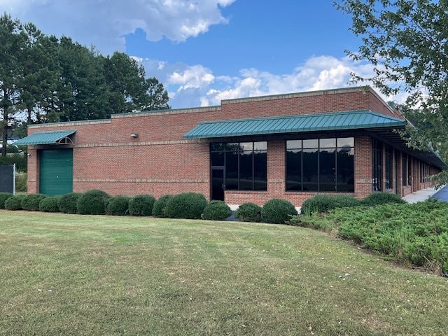
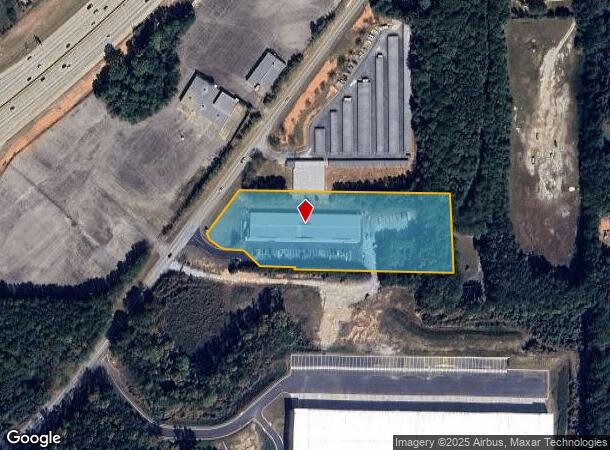
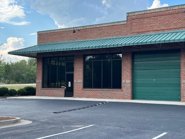
Property Detail
195 Raymond Hill Rd
120-6042-001
BLDG/3.662 AC ( TR A) LL 42 6 LD
Storesoffices
Coweta
X
Georgia
13077C0160D
41
2025
3.66 AC
2025
Fayette/Coweta County
170404
Atlanta
29,160 SF
Atlanta-Sandy Springs-Roswell, GA
DEMOGRAPHICS near 195 Raymond Hill Rd
1 Mile
3 Mile
5 Mile
2024 Total Population
1,479
16,000
48,606
2029 Population
1,633
17,637
53,557
Pop Growth 2024-2029
+ 10.41%
+ 10.23%
+ 10.19%
Average Age
40
41
41
2024 Total Households
500
5,567
17,635
HH Growth 2024-2029
+ 10.40%
+ 10.29%
+ 10.25%
Median Household Inc
$110,312
$115,624
$102,190
Avg Household Size
2.90
2.80
2.70
2024 Avg HH Vehicles
2.00
3.00
2.00
Median Home Value
$297,402
$323,383
$319,637
Median Year Built
1995
1996
1997
Nearby Places
- Restaurants
- Banks
- Shops
- Fitness
- Groceries
PUBLIC TRANSPORTATION
AIRPORT
Hartsfield - Jackson Atlanta International
DRIVE
WALK
Distance
Hartsfield - Jackson Atlanta International
33 min
24.7 mi
Nearby Properties
Address
Land Use
TOTAL SIZE
Lot Size
Zoning
Address
Land Use
TOTAL SIZE
Lot Size
Zoning
1,001,000 SF
118.56 AC
R1
Address
Land Use
TOTAL SIZE
Lot Size
Zoning
1,079,000 SF
73.44 AC
M
Address
Land Use
TOTAL SIZE
Lot Size
Zoning
1,206,927 SF
109.06 AC
R1
Address
Land Use
TOTAL SIZE
Lot Size
Zoning
1,206,927 SF
109.06 AC
R1
Address
Land Use
TOTAL SIZE
Lot Size
Zoning
293,156 SF
59.97 AC
R1
Address
Land Use
TOTAL SIZE
Lot Size
Zoning
76,445 SF
25.12 AC
R1
Address
Land Use
TOTAL SIZE
Lot Size
Zoning
457,922 SF
45.16 AC
R1
Address
Land Use
TOTAL SIZE
Lot Size
Zoning
215,344 SF
28.12 AC
R1
Address
Land Use
TOTAL SIZE
Lot Size
Zoning
299,520 SF
32.45 AC
R1
Address
Land Use
TOTAL SIZE
Lot Size
Zoning
145,198 SF
52.44 AC
R1
Address
Land Use
TOTAL SIZE
Lot Size
Zoning
216,250 SF
20.12 AC
R1
Address
Land Use
TOTAL SIZE
Lot Size
Zoning
121,290 SF
11.74 AC
R1
Address
Land Use
TOTAL SIZE
Lot Size
Zoning
186,249 SF
17.99 AC
R1
Address
Land Use
TOTAL SIZE
Lot Size
Zoning
186,695 SF
29.47 AC
R1
Address
Land Use
TOTAL SIZE
Lot Size
Zoning
112,650 SF
5.70 AC
002
Address
Land Use
TOTAL SIZE
Lot Size
Zoning
90,474 SF
12.56 AC
C
Address
Land Use
TOTAL SIZE
Lot Size
Zoning
117,635 SF
20 AC
001
Address
Land Use
TOTAL SIZE
Lot Size
Zoning
28,753 SF
4.83 AC
R1
Address
Land Use
TOTAL SIZE
Lot Size
Zoning
103,594 SF
18.83 AC
R1
Address
Land Use
TOTAL SIZE
Lot Size
Zoning
47,540 SF
6.33 AC
R1
Address
Land Use
TOTAL SIZE
Lot Size
Zoning
75,847 SF
15.82 AC
R1
Address
Land Use
TOTAL SIZE
Lot Size
Zoning
106,920 SF
14.15 AC
R1
Address
Land Use
TOTAL SIZE
Lot Size
Zoning
106,920 SF
14.15 AC
R1
Address
Land Use
TOTAL SIZE
Lot Size
Zoning
33,276 SF
21.02 AC
R1
Address
Land Use
TOTAL SIZE
Lot Size
Zoning
37.78 AC
002
Address
Land Use
TOTAL SIZE
Lot Size
Zoning
76,920 SF
6.40 AC
R1
Address
Land Use
TOTAL SIZE
Lot Size
Zoning
67,604 SF
29.71 AC
R1
Address
Land Use
TOTAL SIZE
Lot Size
Zoning
31,256 SF
20.15 AC
R1
Address
Land Use
TOTAL SIZE
Lot Size
Zoning
59,730 SF
18.33 AC
R1
Address
Land Use
TOTAL SIZE
Lot Size
Zoning
59,730 SF
18.33 AC
R1
The World's #1 Commercial Real Estate Marketplace
Connect with us
© 2025 CoStar Group
The information above has been obtained from sources believed reliable. While we do not doubt its accuracy we have not verified it and make no guarantee, warranty or representation about it. It is your responsibility to independently confirm its accuracy and completeness. Any projections, opinions, assumptions, or estimates used are for example only and do not represent the current or future performance of the property. The value of this transaction to you depends on tax and other factors which should be evaluated by your tax, financial, and legal advisors. You and your advisors should conduct a careful, independent investigation of the property to determine to your satisfaction the suitability of the property for your needs.