Property Record
95 Runnells Bridge Rd, Hollis, NH 03049
This Property Is For Sale
NEARBY LISTINGS FOR SALE OR LEASE
Property Detail
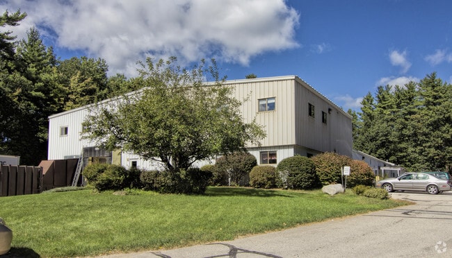
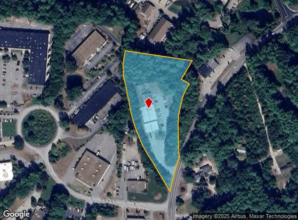
95 Runnells Bridge Rd
Industrialgeneral
Hillsborough
X
New Hampshire
25017C0083F
4.19 AC
2024
Hillsborough
2024
Boston
017101
Manchester-Nashua, NH
23,720 SF
HOLS-000005-000000-000001
DEMOGRAPHICS near 95 Runnells Bridge Rd
1 Mile
3 Mile
5 Mile
2024 Total Population
1,910
16,695
64,132
2029 Population
1,920
16,889
64,863
Pop Growth 2024-2029
+ 0.52%
+ 1.16%
+ 1.14%
Average Age
46
44
43
2024 Total Households
741
6,505
25,180
HH Growth 2024-2029
+ 0.54%
+ 1.20%
+ 1.15%
Median Household Inc
$134,722
$118,181
$112,019
Avg Household Size
2.60
2.60
2.50
2024 Avg HH Vehicles
2.00
2.00
2.00
Median Home Value
$488,461
$421,625
$400,220
Median Year Built
1988
1983
1979
Nearby Places
Map Layers
Map Styles
 Street
 Aerial
- Restaurants
- Banks
- Shops
- Fitness
- Groceries
PUBLIC TRANSPORTATION
AIRPORT
Manchester Boston Regional
DRIVE
WALK
Distance
Manchester Boston Regional
33 min
19.7 mi
Freight Ports
Port of Boston
DRIVE
WALK
Distance
Port of Boston
74 min
52.4 mi
Nearby Properties
Address
Land Use
TOTAL SIZE
Lot Size
Zoning
Address
Land Use
TOTAL SIZE
Lot Size
Zoning
42.06 AC
IND
Address
Land Use
TOTAL SIZE
Lot Size
Zoning
153,429 SF
76 AC
TC
Address
Land Use
TOTAL SIZE
Lot Size
Zoning
Address
Land Use
TOTAL SIZE
Lot Size
Zoning
1,440 SF
111.23 AC
R9
Address
Land Use
TOTAL SIZE
Lot Size
Zoning
3.75 AC
R9
Address
Land Use
TOTAL SIZE
Lot Size
Zoning
297.34 AC
R30
Address
Land Use
TOTAL SIZE
Lot Size
Zoning
64,987 SF
58 AC
R30
Address
Land Use
TOTAL SIZE
Lot Size
Zoning
96,025 SF
8.63 AC
TC
Address
Land Use
TOTAL SIZE
Lot Size
Zoning
12.43 AC
R40
Address
Land Use
TOTAL SIZE
Lot Size
Zoning
9.16 AC
IND
Address
Land Use
TOTAL SIZE
Lot Size
Zoning
28,720 SF
11.58 AC
R9
Address
Land Use
TOTAL SIZE
Lot Size
Zoning
51.83 AC
R9
Address
Land Use
TOTAL SIZE
Lot Size
Zoning
2,380 SF
44.26 AC
MH1
Address
Land Use
TOTAL SIZE
Lot Size
Zoning
12.63 AC
R9
Address
Land Use
TOTAL SIZE
Lot Size
Zoning
13.19 AC
SUR
Address
Land Use
TOTAL SIZE
Lot Size
Zoning
1,288 SF
31.64 AC
R9
Address
Land Use
TOTAL SIZE
Lot Size
Zoning
36,856 SF
5.66 AC
R9
Address
Land Use
TOTAL SIZE
Lot Size
Zoning
12.07 AC
R40
Address
Land Use
TOTAL SIZE
Lot Size
Zoning
6.69 AC
R30
Address
Land Use
TOTAL SIZE
Lot Size
Zoning
927 SF
0.63 AC
TC
Address
Land Use
TOTAL SIZE
Lot Size
Zoning
3,023 SF
16 AC
RA
Address
Land Use
TOTAL SIZE
Lot Size
Zoning
9 AC
R9
Address
Land Use
TOTAL SIZE
Lot Size
Zoning
175.67 AC
RUR
Address
Land Use
TOTAL SIZE
Lot Size
Zoning
80.04 AC
R40
Address
Land Use
TOTAL SIZE
Lot Size
Zoning
9,634 SF
R30
Address
Land Use
TOTAL SIZE
Lot Size
Zoning
47,310 SF
128.83 AC
AB
Address
Land Use
TOTAL SIZE
Lot Size
Zoning
34,620 SF
6.02 AC
IN
Address
Land Use
TOTAL SIZE
Lot Size
Zoning
25,400 SF
9.30 AC
IND
Address
Land Use
TOTAL SIZE
Lot Size
Zoning
13,365 SF
2.11 AC
AB
The World's #1 Commercial Real Estate Marketplace
Connect with us
© 2025 CoStar Group
The information above has been obtained from sources believed reliable. While we do not doubt its accuracy we have not verified it and make no guarantee, warranty or representation about it. It is your responsibility to independently confirm its accuracy and completeness. Any projections, opinions, assumptions, or estimates used are for example only and do not represent the current or future performance of the property. The value of this transaction to you depends on tax and other factors which should be evaluated by your tax, financial, and legal advisors. You and your advisors should conduct a careful, independent investigation of the property to determine to your satisfaction the suitability of the property for your needs.