Property Record
95 S Main St, Kamas, UT 84036
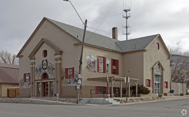

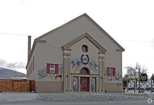
Property Detail
95 S Main St
Heber, UT
BEG 36 RODS N OF SW COR OF SEC 16 T2SR6E SLBM; TH N 8 RODS 3 FT; TH E 9 RODS 1 FT; TH S 8 RODS 3 FT; TH W 9 RODS 1 FT TO BEG CONT 70 1/2 SQ RODS BEING PART OF LOT 1 BLK 26 KAMAS TOWNSITE CONT .46 AC360-655-656 749-498 (REF:1083-833-834-835) 1083-832-
KT-86
Summit
Commercialbuilding
Utah
B and X Area of moderate flood hazard, usually the area between the limits of the 100-year and 500-year floods.
1
2025
0.46 AC
2025
Outlying Summit County
964201
Salt Lake City
9,887 SF
NEARBY LISTINGS FOR SALE OR LEASE
-
-
View all Kamas listings for sale on LoopNet.com
DEMOGRAPHICS near 95 S Main St
1 mile
3 mile
5 mile
2025 Total Population
1,319
3,703
5,620
2030 Population
1,230
3,502
5,422
Pop Growth 2025-2030
(6.75%)
(5.43%)
(3.52%)
Average Age
37
37
38
2025 Total Households
435
1,221
1,911
HH Growth 2025-2030
(7.36%)
(6.06%)
(3.66%)
Median Household Inc
$112,061
$112,500
$114,903
Avg Household Size
2.90
3.00
2.90
2025 Avg HH Vehicles
3.00
3.00
3.00
Median Home Value
$735,576
$749,462
$766,333
Median Year Built
1998
1999
2000
Nearby Places
Map Layers
Map Styles
 Street
 Aerial
Layers
 Traffic
 Biking
Places
Listings with unknown addresses are not visible on the map
- Restaurants
- Banks
- Shops
- Fitness
- Groceries
Nearby Properties
Address
Land Use
TOTAL SIZE
Lot Size
Zoning
Address
Land Use
TOTAL SIZE
Lot Size
Zoning
5,204 SF
10.89 AC
Address
Land Use
TOTAL SIZE
Lot Size
Zoning
9.64 AC
Address
Land Use
TOTAL SIZE
Lot Size
Zoning
58,140 SF
4.78 AC
Address
Land Use
TOTAL SIZE
Lot Size
Zoning
1,308 SF
23.61 AC
Address
Land Use
TOTAL SIZE
Lot Size
Zoning
33,884 SF
7.12 AC
Address
Land Use
TOTAL SIZE
Lot Size
Zoning
3.09 AC
Address
Land Use
TOTAL SIZE
Lot Size
Zoning
2,488 SF
30.03 AC
Address
Land Use
TOTAL SIZE
Lot Size
Zoning
20,205 SF
1 AC
Address
Land Use
TOTAL SIZE
Lot Size
Zoning
20,090 SF
2.36 AC
Address
Land Use
TOTAL SIZE
Lot Size
Zoning
2.26 AC
Address
Land Use
TOTAL SIZE
Lot Size
Zoning
780 SF
2.36 AC
Address
Land Use
TOTAL SIZE
Lot Size
Zoning
30,623 SF
2.29 AC
Address
Land Use
TOTAL SIZE
Lot Size
Zoning
19,486 SF
1.22 AC
Address
Land Use
TOTAL SIZE
Lot Size
Zoning
13,471 SF
17.80 AC
Address
Land Use
TOTAL SIZE
Lot Size
Zoning
15,120 SF
2.56 AC
Address
Land Use
TOTAL SIZE
Lot Size
Zoning
Address
Land Use
TOTAL SIZE
Lot Size
Zoning
16,941 SF
2.50 AC
Address
Land Use
TOTAL SIZE
Lot Size
Zoning
16,686 SF
3.25 AC
Address
Land Use
TOTAL SIZE
Lot Size
Zoning
20,520 SF
4.29 AC
Address
Land Use
TOTAL SIZE
Lot Size
Zoning
5,119 SF
26.96 AC
Address
Land Use
TOTAL SIZE
Lot Size
Zoning
23,928 SF
1.01 AC
Address
Land Use
TOTAL SIZE
Lot Size
Zoning
4.38 AC
Address
Land Use
TOTAL SIZE
Lot Size
Zoning
13,020 SF
40.92 AC
Address
Land Use
TOTAL SIZE
Lot Size
Zoning
2,352 SF
27.76 AC
Address
Land Use
TOTAL SIZE
Lot Size
Zoning
30.23 AC
Address
Land Use
TOTAL SIZE
Lot Size
Zoning
9.92 AC
The World's #1 Commercial Real Estate Marketplace
Connect with us
© 2026 CoStar Group
The information above has been obtained from sources believed reliable. While we do not doubt its accuracy we have not verified it and make no guarantee, warranty or representation about it. It is your responsibility to independently confirm its accuracy and completeness. Any projections, opinions, assumptions, or estimates used are for example only and do not represent the current or future performance of the property. The value of this transaction to you depends on tax and other factors which should be evaluated by your tax, financial, and legal advisors. You and your advisors should conduct a careful, independent investigation of the property to determine to your satisfaction the suitability of the property for your needs.