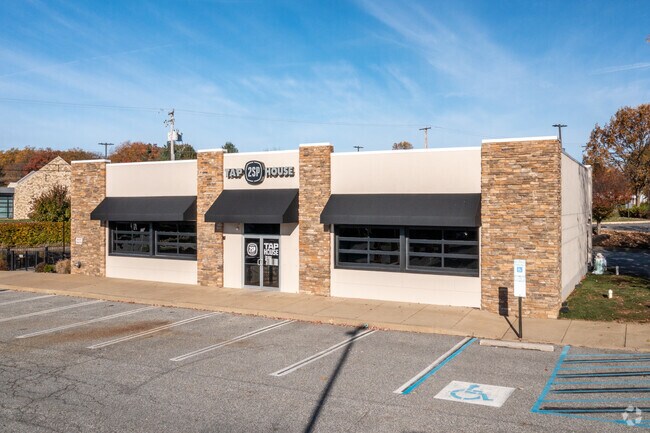
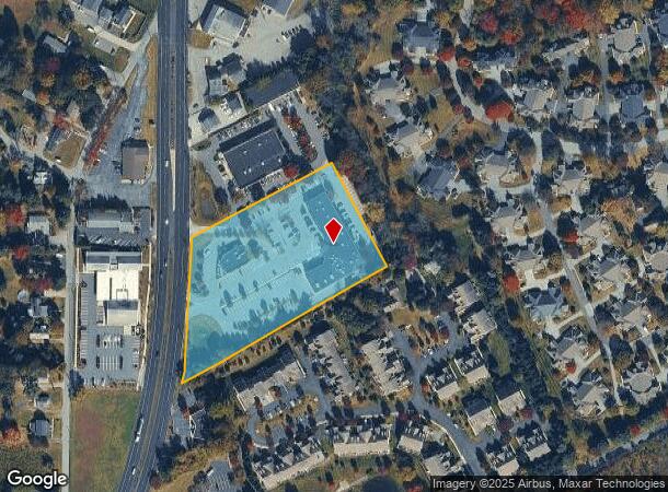
Property Record
91 Wilmington W Chester Pike, Chadds Ford, PA 19317


Current Lease Availabilities
NEARBY LISTINGS FOR SALE OR LEASE
Property Detail
91 Wilmington W Chester Pike
13-00-00996-03
Norman J Schwartz
Restaurantbuilding
2-1 STY BLDGS 4.74AC
X
Delaware
10003C0060K
Pennsylvania
2024
4.74 AC
2025
Delaware County
410200
Philadelphia
20,180 SF
Philadelphia-Camden-Wilmington, PA-NJ-DE-MD
DEMOGRAPHICS near 91 Wilmington W Chester Pike
1 Mile
3 Mile
5 Mile
2024 Total Population
6,435
41,098
112,397
2029 Population
6,395
41,322
112,901
Pop Growth 2024-2029
(0.62%)
+ 0.55%
+ 0.45%
Average Age
43
45
44
2024 Total Households
2,498
16,141
44,731
HH Growth 2024-2029
(0.56%)
+ 0.46%
+ 0.48%
Median Household Inc
$127,176
$121,049
$108,034
Avg Household Size
2.50
2.50
2.50
2024 Avg HH Vehicles
2.00
2.00
2.00
Median Home Value
$478,831
$430,289
$396,294
Median Year Built
1991
1978
1972
Nearby Places
- Restaurants
- Banks
- Shops
- Fitness
- Groceries
PUBLIC TRANSPORTATION
COMMUTER RAIL
DRIVE
WALK
Distance
15 min
7.4 mi
Claymont (R2 - Southeastern Pennsylvania Transportation Authority Regional Rail (SEPTA Regional Rail))
DRIVE
WALK
Distance
Claymont (R2 - Southeastern Pennsylvania Transportation Authority Regional Rail (SEPTA Regional Rail))
16 min
7.5 mi
AIRPORT
Philadelphia International
DRIVE
WALK
Distance
Philadelphia International
32 min
19.2 mi
Freight Ports
Port of Wilmington, RI
DRIVE
WALK
Distance
Port of Wilmington, RI
24 min
11.0 mi
Nearby Properties
Address
Land Use
TOTAL SIZE
Lot Size
Zoning
Address
Land Use
TOTAL SIZE
Lot Size
Zoning
58,598 SF
87.20 AC
Address
Land Use
TOTAL SIZE
Lot Size
Zoning
196,366 SF
106.66 AC
Address
Land Use
TOTAL SIZE
Lot Size
Zoning
36,463 SF
13 AC
Address
Land Use
TOTAL SIZE
Lot Size
Zoning
62,280 SF
13.56 AC
Address
Land Use
TOTAL SIZE
Lot Size
Zoning
32,649 SF
23.70 AC
Address
Land Use
TOTAL SIZE
Lot Size
Zoning
300,410 SF
48 AC
Address
Land Use
TOTAL SIZE
Lot Size
Zoning
3,660 SF
48.94 AC
Address
Land Use
TOTAL SIZE
Lot Size
Zoning
153,000 SF
29.58 AC
Address
Land Use
TOTAL SIZE
Lot Size
Zoning
81,840 SF
16.88 AC
Address
Land Use
TOTAL SIZE
Lot Size
Zoning
266,702 SF
20.04 AC
OR
Address
Land Use
TOTAL SIZE
Lot Size
Zoning
199,099 SF
49 AC
S
Address
Land Use
TOTAL SIZE
Lot Size
Zoning
37,620 SF
21.88 AC
Address
Land Use
TOTAL SIZE
Lot Size
Zoning
162,643 SF
30.61 AC
CR
Address
Land Use
TOTAL SIZE
Lot Size
Zoning
131,612 SF
19.79 AC
Address
Land Use
TOTAL SIZE
Lot Size
Zoning
210,238 SF
31.35 AC
S
Address
Land Use
TOTAL SIZE
Lot Size
Zoning
75,456 SF
2.40 AC
Address
Land Use
TOTAL SIZE
Lot Size
Zoning
92,160 SF
58.23 AC
Address
Land Use
TOTAL SIZE
Lot Size
Zoning
346,808 SF
17.92 AC
OR
Address
Land Use
TOTAL SIZE
Lot Size
Zoning
96,745 SF
17.07 AC
S
Address
Land Use
TOTAL SIZE
Lot Size
Zoning
223,495 SF
55 AC
Address
Land Use
TOTAL SIZE
Lot Size
Zoning
106,150 SF
10.69 AC
Address
Land Use
TOTAL SIZE
Lot Size
Zoning
82,840 SF
5 AC
Address
Land Use
TOTAL SIZE
Lot Size
Zoning
128,467 SF
54.30 AC
Address
Land Use
TOTAL SIZE
Lot Size
Zoning
197,332 SF
12.13 AC
S
Address
Land Use
TOTAL SIZE
Lot Size
Zoning
126,513 SF
10.47 AC
Address
Land Use
TOTAL SIZE
Lot Size
Zoning
113,460 SF
11.40 AC
Address
Land Use
TOTAL SIZE
Lot Size
Zoning
380 SF
21.54 AC
S
Address
Land Use
TOTAL SIZE
Lot Size
Zoning
55,252 SF
24.09 AC
Address
Land Use
TOTAL SIZE
Lot Size
Zoning
74,612 SF
5.05 AC
Address
Land Use
TOTAL SIZE
Lot Size
Zoning
5,088 SF
24.92 AC
The World's #1 Commercial Real Estate Marketplace
Connect with us
© 2025 CoStar Group
The information above has been obtained from sources believed reliable. While we do not doubt its accuracy we have not verified it and make no guarantee, warranty or representation about it. It is your responsibility to independently confirm its accuracy and completeness. Any projections, opinions, assumptions, or estimates used are for example only and do not represent the current or future performance of the property. The value of this transaction to you depends on tax and other factors which should be evaluated by your tax, financial, and legal advisors. You and your advisors should conduct a careful, independent investigation of the property to determine to your satisfaction the suitability of the property for your needs.