Property Record
95 Wooster Ct, Bristol, CT 06010
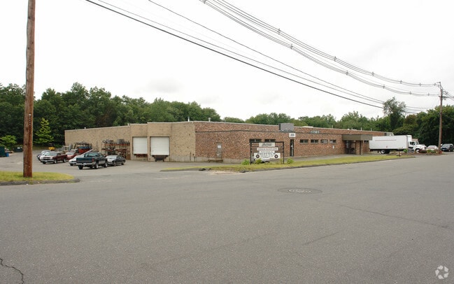

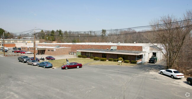
Property Detail
95 Wooster Ct
BRIS-000042-000000-000004-083232
Naugatuck Vly
Manufacturinglight
Connecticut
I
4-83232
B and X Area of moderate flood hazard, usually the area between the limits of the 100-year and 500-year floods.
2.25 AC
2025
Bristol
2025
Hartford
405200
Hartford-West Hartford-East Hartford, CT
55,522 SF
NEARBY LISTINGS FOR SALE OR LEASE
DEMOGRAPHICS near 95 Wooster Ct
1 mile
3 mile
5 mile
2025 Total Population
8,069
62,294
131,332
2030 Population
8,230
63,886
134,385
Pop Growth 2025-2030
+ 2.00%
+ 2.56%
+ 2.32%
Average Age
43
43
42
2025 Total Households
3,476
27,114
54,499
HH Growth 2025-2030
+ 1.93%
+ 2.54%
+ 2.36%
Median Household Inc
$88,996
$79,680
$85,988
Avg Household Size
2.30
2.20
2.30
2025 Avg HH Vehicles
2.00
2.00
2.00
Median Home Value
$269,896
$269,303
$298,124
Median Year Built
1966
1967
1968
Nearby Places
Map Layers
Map Styles
 Street
 Aerial
Layers
 Traffic
 Biking
Places
Listings with unknown addresses are not visible on the map
- Restaurants
- Banks
- Shops
- Fitness
- Groceries
PUBLIC TRANSPORTATION
COMMUTER RAIL
Drive
Walk
Distance
15 min
8.0 mi
Drive
Walk
Distance
15 min
8.0 mi
AIRPORT
Bradley International
Drive
Walk
Distance
Bradley International
54 min
29.4 mi
Tweed/New Haven
Drive
Walk
Distance
Tweed/New Haven
49 min
32.6 mi
SALE & LEASE HISTORY
LISTING DATE
SALE/LEASE

Apr 18, 2019
For Lease
Nearby Properties
Address
Land Use
TOTAL SIZE
Lot Size
Zoning
Address
Land Use
TOTAL SIZE
Lot Size
Zoning
268,369 SF
13.32 AC
B1
Address
Land Use
TOTAL SIZE
Lot Size
Zoning
77,001 SF
54.59 AC
IP-1
Address
Land Use
TOTAL SIZE
Lot Size
Zoning
349,054 SF
12.03 AC
R-15
Address
Land Use
TOTAL SIZE
Lot Size
Zoning
100,304 SF
28.80 AC
IP-1
Address
Land Use
TOTAL SIZE
Lot Size
Zoning
134,488 SF
63.26 AC
GC
Address
Land Use
TOTAL SIZE
Lot Size
Zoning
58,473 SF
18.20 AC
IP-1
Address
Land Use
TOTAL SIZE
Lot Size
Zoning
137,242 SF
25.80 AC
R40
Address
Land Use
TOTAL SIZE
Lot Size
Zoning
145,719 SF
17.90 AC
R-15
Address
Land Use
TOTAL SIZE
Lot Size
Zoning
114,375 SF
12.72 AC
IP-1
Address
Land Use
TOTAL SIZE
Lot Size
Zoning
330,400 SF
36.90 AC
IP-1
Address
Land Use
TOTAL SIZE
Lot Size
Zoning
182,930 SF
15.70 AC
SA
Address
Land Use
TOTAL SIZE
Lot Size
Zoning
28.47 AC
R-10
Address
Land Use
TOTAL SIZE
Lot Size
Zoning
48.09 AC
CR
Address
Land Use
TOTAL SIZE
Lot Size
Zoning
12,892 SF
20.91 AC
A
Address
Land Use
TOTAL SIZE
Lot Size
Zoning
56,184 SF
19.42 AC
BG
Address
Land Use
TOTAL SIZE
Lot Size
Zoning
288,827 SF
24.01 AC
RI
Address
Land Use
TOTAL SIZE
Lot Size
Zoning
103,886 SF
10.47 AC
BR
Address
Land Use
TOTAL SIZE
Lot Size
Zoning
199,744 SF
44.70 AC
R-15
Address
Land Use
TOTAL SIZE
Lot Size
Zoning
62,232 SF
0.90 AC
BD-1
Address
Land Use
TOTAL SIZE
Lot Size
Zoning
54,904 SF
7.01 AC
A
Address
Land Use
TOTAL SIZE
Lot Size
Zoning
133,673 SF
30.40 AC
R-40
Address
Land Use
TOTAL SIZE
Lot Size
Zoning
502,440 SF
27.87 AC
I-2
Address
Land Use
TOTAL SIZE
Lot Size
Zoning
4,000 SF
13.78 AC
BG
Address
Land Use
TOTAL SIZE
Lot Size
Zoning
17.62 AC
B
Address
Land Use
TOTAL SIZE
Lot Size
Zoning
1,700 SF
38.81 AC
A
Address
Land Use
TOTAL SIZE
Lot Size
Zoning
120,801 SF
8.35 AC
R-40
Address
Land Use
TOTAL SIZE
Lot Size
Zoning
29.05 AC
R-20
Address
Land Use
TOTAL SIZE
Lot Size
Zoning
149,912 SF
13.66 AC
B
Address
Land Use
TOTAL SIZE
Lot Size
Zoning
143,315 SF
4.50 AC
A
Address
Land Use
TOTAL SIZE
Lot Size
Zoning
3,084 SF
14.90 AC
BG
The World's #1 Commercial Real Estate Marketplace
Connect with us
© 2026 CoStar Group
The information above has been obtained from sources believed reliable. While we do not doubt its accuracy we have not verified it and make no guarantee, warranty or representation about it. It is your responsibility to independently confirm its accuracy and completeness. Any projections, opinions, assumptions, or estimates used are for example only and do not represent the current or future performance of the property. The value of this transaction to you depends on tax and other factors which should be evaluated by your tax, financial, and legal advisors. You and your advisors should conduct a careful, independent investigation of the property to determine to your satisfaction the suitability of the property for your needs.