Property Record
950 E Parham Rd, Henrico, VA 23228
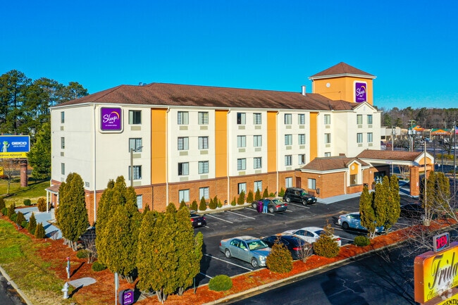

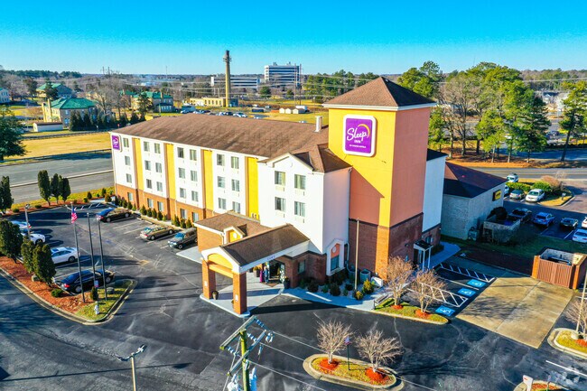
Property Detail
950 E Parham Rd
783-756-8367
00630A0000 0004A; HUNGARY RD AC 1.82 104 B1 21
Hotelormotel
Henrico
MIXE
Virginia
B and X Area of moderate flood hazard, usually the area between the limits of the 100-year and 500-year floods.
1.82 AC
2025
Richmond Northwest/Glen Allen
2025
Richmond VA
200905
Richmond, VA
30,143 SF
NEARBY LISTINGS FOR SALE OR LEASE
-
-
View all Henrico listings for sale on LoopNet.com
DEMOGRAPHICS near 950 E Parham Rd
1 mile
3 mile
5 mile
2025 Total Population
5,733
59,100
175,019
2030 Population
5,877
60,296
179,687
Pop Growth 2025-2030
+ 2.51%
+ 2.02%
+ 2.67%
Average Age
41
41
41
2025 Total Households
2,504
25,081
74,304
HH Growth 2025-2030
+ 2.32%
+ 2.07%
+ 2.87%
Median Household Inc
$77,083
$77,968
$84,873
Avg Household Size
2.20
2.30
2.30
2025 Avg HH Vehicles
2.00
2.00
2.00
Median Home Value
$289,133
$314,119
$356,906
Median Year Built
1978
1976
1976
Nearby Places
Map Layers
Map Styles
 Street
 Aerial
Layers
 Traffic
 Biking
Places
Listings with unknown addresses are not visible on the map
- Restaurants
- Banks
- Shops
- Fitness
- Groceries
PUBLIC TRANSPORTATION
COMMUTER RAIL
Richmond Staples Mill Road Amtrak Station (Carolinian - Amtrak, Northeast Regional - Amtrak, Palmetto - Amtrak, Silver Meteor - Amtrak)
Drive
Walk
Distance
Richmond Staples Mill Road Amtrak Station (Carolinian - Amtrak, Northeast Regional - Amtrak, Palmetto - Amtrak, Silver Meteor - Amtrak)
8 min
4.3 mi
Richmond Main Street Amtrak Station (Northeast Regional - Amtrak)
Drive
Walk
Distance
Richmond Main Street Amtrak Station (Northeast Regional - Amtrak)
13 min
8.7 mi
AIRPORT
Richmond International
Drive
Walk
Distance
Richmond International
26 min
16.6 mi
Freight Ports
Virginia Port Authority - Richmond
Drive
Walk
Distance
Virginia Port Authority - Richmond
24 min
14.9 mi
Nearby Properties
Address
Land Use
TOTAL SIZE
Lot Size
Zoning
Address
Land Use
TOTAL SIZE
Lot Size
Zoning
494,791 SF
38.85 AC
R-6
Address
Land Use
TOTAL SIZE
Lot Size
Zoning
43,929 SF
46.83 AC
O-S
Address
Land Use
TOTAL SIZE
Lot Size
Zoning
104,972 SF
108.49 AC
MIXE
Address
Land Use
TOTAL SIZE
Lot Size
Zoning
347,648 SF
24.75 AC
R-5
Address
Land Use
TOTAL SIZE
Lot Size
Zoning
186,034 SF
13.86 AC
B-3C
Address
Land Use
TOTAL SIZE
Lot Size
Zoning
1,404 SF
30.52 AC
R-5
Address
Land Use
TOTAL SIZE
Lot Size
Zoning
135,874 SF
31.99 AC
MIXE
Address
Land Use
TOTAL SIZE
Lot Size
Zoning
110,790 SF
37.61 AC
R-2A
Address
Land Use
TOTAL SIZE
Lot Size
Zoning
180,070 SF
17.13 AC
R-5
Address
Land Use
TOTAL SIZE
Lot Size
Zoning
102,942 SF
71.86 AC
MIXE
Address
Land Use
TOTAL SIZE
Lot Size
Zoning
104,023 SF
98.16 AC
MIXE
Address
Land Use
TOTAL SIZE
Lot Size
Zoning
213,344 SF
16.28 AC
R-5
Address
Land Use
TOTAL SIZE
Lot Size
Zoning
24,165 SF
72.13 AC
C-1
Address
Land Use
TOTAL SIZE
Lot Size
Zoning
226,400 SF
14.70 AC
R-5
Address
Land Use
TOTAL SIZE
Lot Size
Zoning
10,818 SF
161.99 AC
MIXE
Address
Land Use
TOTAL SIZE
Lot Size
Zoning
62,919 SF
17.87 AC
R-3
Address
Land Use
TOTAL SIZE
Lot Size
Zoning
251,400 SF
16.18 AC
R-6C
Address
Land Use
TOTAL SIZE
Lot Size
Zoning
160,000 SF
25 AC
M-1
Address
Land Use
TOTAL SIZE
Lot Size
Zoning
216,900 SF
13.41 AC
R-6
Address
Land Use
TOTAL SIZE
Lot Size
Zoning
274,284 SF
0.02 AC
R-6C
Address
Land Use
TOTAL SIZE
Lot Size
Zoning
138,140 SF
7.66 AC
R-6
Address
Land Use
TOTAL SIZE
Lot Size
Zoning
114,958 SF
20 AC
R-4
Address
Land Use
TOTAL SIZE
Lot Size
Zoning
7,295 SF
72.17 AC
Address
Land Use
TOTAL SIZE
Lot Size
Zoning
112,893 SF
58.52 AC
MIXE
Address
Land Use
TOTAL SIZE
Lot Size
Zoning
228,744 SF
21.11 AC
R-5
Address
Land Use
TOTAL SIZE
Lot Size
Zoning
227,008 SF
20.94 AC
R-5
Address
Land Use
TOTAL SIZE
Lot Size
Zoning
11.06 AC
R-6
Address
Land Use
TOTAL SIZE
Lot Size
Zoning
211,614 SF
16.21 AC
R-5
Address
Land Use
TOTAL SIZE
Lot Size
Zoning
71,282 SF
12.97 AC
R-3
Address
Land Use
TOTAL SIZE
Lot Size
Zoning
199,835 SF
30.56 AC
R-5 SINGLE
The World's #1 Commercial Real Estate Marketplace
Connect with us
© 2026 CoStar Group
The information above has been obtained from sources believed reliable. While we do not doubt its accuracy we have not verified it and make no guarantee, warranty or representation about it. It is your responsibility to independently confirm its accuracy and completeness. Any projections, opinions, assumptions, or estimates used are for example only and do not represent the current or future performance of the property. The value of this transaction to you depends on tax and other factors which should be evaluated by your tax, financial, and legal advisors. You and your advisors should conduct a careful, independent investigation of the property to determine to your satisfaction the suitability of the property for your needs.