Property Record
950 Flanders Rd, Mystic, CT 06355
NEARBY LISTINGS FOR SALE OR LEASE
-
-
View all Mystic listings for sale on LoopNet.com
Property Detail
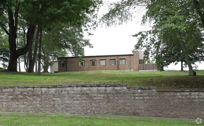
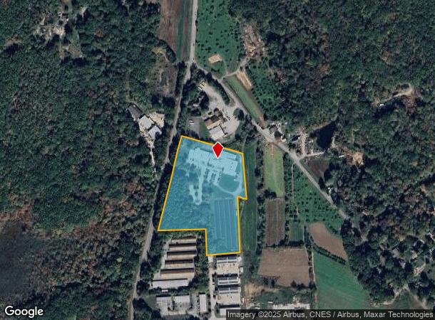
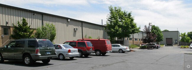
950 Flanders Rd
Manufacturinglight
New London
X
Connecticut
09011C0369G
11.05 AC
2025
New London
2025
Hartford
702100
Norwich-New London, CT
36,624 SF
GROT-002609-000648-005544
DEMOGRAPHICS near 950 Flanders Rd
1 Mile
3 Mile
5 Mile
2024 Total Population
1,077
22,577
55,126
2029 Population
1,071
22,688
55,306
Pop Growth 2024-2029
(0.56%)
+ 0.49%
+ 0.33%
Average Age
43
44
42
2024 Total Households
431
9,547
23,398
HH Growth 2024-2029
(0.70%)
+ 0.37%
+ 0.33%
Median Household Inc
$101,637
$88,045
$82,376
Avg Household Size
2.30
2.20
2.20
2024 Avg HH Vehicles
2.00
2.00
2.00
Median Home Value
$262,162
$314,076
$306,267
Median Year Built
1968
1974
1973
Nearby Places
Map Layers
Map Styles
 Street
 Aerial
- Restaurants
- Banks
- Shops
- Fitness
- Groceries
PUBLIC TRANSPORTATION
COMMUTER RAIL
DRIVE
WALK
Distance
10 min
4.4 mi
New London (Shore Line East - Shore Line East)
DRIVE
WALK
Distance
New London (Shore Line East - Shore Line East)
14 min
7.7 mi
AIRPORT
Rhode Island Tf Green International
DRIVE
WALK
Distance
Rhode Island Tf Green International
64 min
45.5 mi
Freight Ports
Port of Davisville, RI
DRIVE
WALK
Distance
Port of Davisville, RI
65 min
45.7 mi
Nearby Properties
Address
Land Use
TOTAL SIZE
Lot Size
Zoning
Address
Land Use
TOTAL SIZE
Lot Size
Zoning
42,688 SF
19.22 AC
RM
Address
Land Use
TOTAL SIZE
Lot Size
Zoning
276.72 AC
GC
Address
Land Use
TOTAL SIZE
Lot Size
Zoning
8,820 SF
66.22 AC
R-12
Address
Land Use
TOTAL SIZE
Lot Size
Zoning
268,573 SF
74.66 AC
RS-20
Address
Land Use
TOTAL SIZE
Lot Size
Zoning
287.66 AC
RU-20
Address
Land Use
TOTAL SIZE
Lot Size
Zoning
18.02 AC
RM-15
Address
Land Use
TOTAL SIZE
Lot Size
Zoning
162,521 SF
44.19 AC
RS-20
Address
Land Use
TOTAL SIZE
Lot Size
Zoning
18.17 AC
TC-80
Address
Land Use
TOTAL SIZE
Lot Size
Zoning
60.63 AC
RU-20
Address
Land Use
TOTAL SIZE
Lot Size
Zoning
104,052 SF
27.36 AC
RM
Address
Land Use
TOTAL SIZE
Lot Size
Zoning
74,433 SF
47.37 AC
RS-20
Address
Land Use
TOTAL SIZE
Lot Size
Zoning
66.87 AC
RU-20
Address
Land Use
TOTAL SIZE
Lot Size
Zoning
231,514 SF
9.33 AC
IM
Address
Land Use
TOTAL SIZE
Lot Size
Zoning
125,275 SF
10 AC
RM
Address
Land Use
TOTAL SIZE
Lot Size
Zoning
33,404 SF
10.15 AC
MVC
Address
Land Use
TOTAL SIZE
Lot Size
Zoning
125,755 SF
14.63 AC
MVC
Address
Land Use
TOTAL SIZE
Lot Size
Zoning
120,243 SF
9.06 AC
TC-80
Address
Land Use
TOTAL SIZE
Lot Size
Zoning
7.35 AC
TC-80
Address
Land Use
TOTAL SIZE
Lot Size
Zoning
520 SF
36.40 AC
RS-20
Address
Land Use
TOTAL SIZE
Lot Size
Zoning
37,434 SF
10.75 AC
MVC
Address
Land Use
TOTAL SIZE
Lot Size
Zoning
58,739 SF
21.85 AC
RU-40
Address
Land Use
TOTAL SIZE
Lot Size
Zoning
7.40 AC
M-1
Address
Land Use
TOTAL SIZE
Lot Size
Zoning
59,024 SF
3.24 AC
RS-12
Address
Land Use
TOTAL SIZE
Lot Size
Zoning
68,206 SF
6.40 AC
M-1
Address
Land Use
TOTAL SIZE
Lot Size
Zoning
19,274 SF
1.36 AC
GB-130
Address
Land Use
TOTAL SIZE
Lot Size
Zoning
39,386 SF
28.74 AC
RS-20
Address
Land Use
TOTAL SIZE
Lot Size
Zoning
1,880 SF
166.33 AC
IM
Address
Land Use
TOTAL SIZE
Lot Size
Zoning
55,089 SF
2.63 AC
GC-60
Address
Land Use
TOTAL SIZE
Lot Size
Zoning
10,056 SF
28.70 AC
R-12
Address
Land Use
TOTAL SIZE
Lot Size
Zoning
26,732 SF
12.44 AC
IM
The World's #1 Commercial Real Estate Marketplace
Connect with us
© 2026 CoStar Group
The information above has been obtained from sources believed reliable. While we do not doubt its accuracy we have not verified it and make no guarantee, warranty or representation about it. It is your responsibility to independently confirm its accuracy and completeness. Any projections, opinions, assumptions, or estimates used are for example only and do not represent the current or future performance of the property. The value of this transaction to you depends on tax and other factors which should be evaluated by your tax, financial, and legal advisors. You and your advisors should conduct a careful, independent investigation of the property to determine to your satisfaction the suitability of the property for your needs.