Property Record
950 Grayson Hwy, Lawrenceville, GA 30046
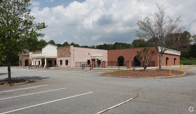

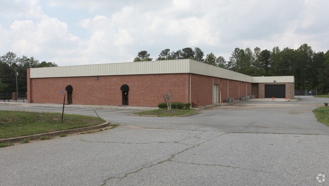

Property Detail
950 Grayson Hwy
5-139-112
GA HWY 20
Religious
GWINNETT
BG
Georgia
B and X Area of moderate flood hazard, usually the area between the limits of the 100-year and 500-year floods.
150
0
8.27 AC
2025
Lawrenceville/Lilburn
050740
Atlanta
24,735 SF
Atlanta-Sandy Springs-Roswell, GA
NEARBY LISTINGS FOR SALE OR LEASE
DEMOGRAPHICS near 950 Grayson Hwy
1 mile
3 mile
5 mile
2025 Total Population
8,048
81,077
192,300
2030 Population
8,428
85,242
201,930
Pop Growth 2025-2030
+ 4.72%
+ 5.14%
+ 5.01%
Average Age
38
38
37
2025 Total Households
2,540
25,844
60,856
HH Growth 2025-2030
+ 4.88%
+ 5.30%
+ 5.13%
Median Household Inc
$81,311
$86,669
$87,880
Avg Household Size
3.00
3.00
3.10
2025 Avg HH Vehicles
2.00
2.00
2.00
Median Home Value
$365,654
$406,087
$393,804
Median Year Built
1988
2000
1998
Nearby Places
Map Layers
Map Styles
 Street
 Aerial
Layers
 Traffic
 Biking
Places
Listings with unknown addresses are not visible on the map
- Restaurants
- Banks
- Shops
- Fitness
- Groceries
PUBLIC TRANSPORTATION
AIRPORT
Hartsfield - Jackson Atlanta International
Drive
Walk
Distance
Hartsfield - Jackson Atlanta International
60 min
43.1 mi
Nearby Properties
Address
Land Use
TOTAL SIZE
Lot Size
Zoning
Address
Land Use
TOTAL SIZE
Lot Size
Zoning
1,218,930 SF
66.65 AC
OI
Address
Land Use
TOTAL SIZE
Lot Size
Zoning
484,262 SF
34.27 AC
RM
Address
Land Use
TOTAL SIZE
Lot Size
Zoning
493,520 SF
12.67 AC
BG2
Address
Land Use
TOTAL SIZE
Lot Size
Zoning
321,476 SF
38.63 AC
RMM
Address
Land Use
TOTAL SIZE
Lot Size
Zoning
16,062 SF
89.78 AC
BG
Address
Land Use
TOTAL SIZE
Lot Size
Zoning
812,946 SF
82.22 AC
BG2
Address
Land Use
TOTAL SIZE
Lot Size
Zoning
352,924 SF
86.43 AC
R100
Address
Land Use
TOTAL SIZE
Lot Size
Zoning
360,279 SF
13.16 AC
RM24
Address
Land Use
TOTAL SIZE
Lot Size
Zoning
333,734 SF
24 AC
BG
Address
Land Use
TOTAL SIZE
Lot Size
Zoning
271,668 SF
20.13 AC
RM13
Address
Land Use
TOTAL SIZE
Lot Size
Zoning
221,082 SF
12.90 AC
RM24
Address
Land Use
TOTAL SIZE
Lot Size
Zoning
201,000 SF
29.98 AC
R75
Address
Land Use
TOTAL SIZE
Lot Size
Zoning
220,161 SF
9.71 AC
OI
Address
Land Use
TOTAL SIZE
Lot Size
Zoning
286,368 SF
34.55 AC
R75
Address
Land Use
TOTAL SIZE
Lot Size
Zoning
214,399 SF
29.91 AC
C2
Address
Land Use
TOTAL SIZE
Lot Size
Zoning
240,509 SF
19.18 AC
RM
Address
Land Use
TOTAL SIZE
Lot Size
Zoning
175,190 SF
11.17 AC
RM
Address
Land Use
TOTAL SIZE
Lot Size
Zoning
231,373 SF
3.82 AC
OI
Address
Land Use
TOTAL SIZE
Lot Size
Zoning
270,396 SF
4.57 AC
OI
Address
Land Use
TOTAL SIZE
Lot Size
Zoning
571,230 SF
64.70 AC
LM
Address
Land Use
TOTAL SIZE
Lot Size
Zoning
145,681 SF
49.84 AC
RA200
Address
Land Use
TOTAL SIZE
Lot Size
Zoning
309,156 SF
17.39 AC
OI
Address
Land Use
TOTAL SIZE
Lot Size
Zoning
126,160 SF
15.15 AC
BG2
Address
Land Use
TOTAL SIZE
Lot Size
Zoning
127,844 SF
7.76 AC
RM8
Address
Land Use
TOTAL SIZE
Lot Size
Zoning
59,949 SF
71.12 AC
C1
Address
Land Use
TOTAL SIZE
Lot Size
Zoning
188,659 SF
5.03 AC
RM13
Address
Land Use
TOTAL SIZE
Lot Size
Zoning
134,512 SF
5.03 AC
RS150
Address
Land Use
TOTAL SIZE
Lot Size
Zoning
132,916 SF
10.23 AC
BG
Address
Land Use
TOTAL SIZE
Lot Size
Zoning
160,939 SF
25.46 AC
R75
Address
Land Use
TOTAL SIZE
Lot Size
Zoning
163,978 SF
14.31 AC
RM12
The World's #1 Commercial Real Estate Marketplace
Connect with us
© 2026 CoStar Group
The information above has been obtained from sources believed reliable. While we do not doubt its accuracy we have not verified it and make no guarantee, warranty or representation about it. It is your responsibility to independently confirm its accuracy and completeness. Any projections, opinions, assumptions, or estimates used are for example only and do not represent the current or future performance of the property. The value of this transaction to you depends on tax and other factors which should be evaluated by your tax, financial, and legal advisors. You and your advisors should conduct a careful, independent investigation of the property to determine to your satisfaction the suitability of the property for your needs.