Property Record
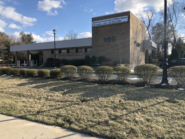
950 State Route 36, Leonardo, NJ 07737


This Property Is For Sale
Current Lease Availabilities
Property Detail
950 State Route 36
32-00436-0000-00011
Monmouth
Financialbuilding
New Jersey
C125
11
B and X Area of moderate flood hazard, usually the area between the limits of the 100-year and 500-year floods.
1.22 AC
2024
Eastern Monmouth
2025
Northern New Jersey
800400
Lakewood-New Brunswick, NJ
3,161 SF
NEARBY LISTINGS FOR SALE OR LEASE
DEMOGRAPHICS near 950 State Route 36
1 mile
3 mile
5 mile
2025 Total Population
7,200
27,952
96,444
2030 Population
7,150
27,937
96,177
Pop Growth 2025-2030
(0.69%)
(0.05%)
(0.28%)
Average Age
43
43
42
2025 Total Households
2,746
11,186
37,067
HH Growth 2025-2030
(0.87%)
(0.02%)
(0.31%)
Median Household Inc
$136,443
$130,646
$129,611
Avg Household Size
2.60
2.40
2.50
2025 Avg HH Vehicles
2.00
2.00
2.00
Median Home Value
$669,861
$641,397
$668,235
Median Year Built
1956
1965
1965
Nearby Places
Map Layers
Map Styles
 Street
 Aerial
Layers
 Traffic
 Biking
Places
Listings with unknown addresses are not visible on the map
- Restaurants
- Banks
- Shops
- Fitness
- Groceries
PUBLIC TRANSPORTATION
COMMUTER RAIL
Middletown Nj (North Jersey Coast Line - NJ TRANSIT RAIL)
Drive
Walk
Distance
Middletown Nj (North Jersey Coast Line - NJ TRANSIT RAIL)
11 min
5.4 mi
Red Bank (North Jersey Coast Line - NJ Transit Commuter Rail (NJ Transit))
Drive
Walk
Distance
Red Bank (North Jersey Coast Line - NJ Transit Commuter Rail (NJ Transit))
14 min
7.6 mi
AIRPORT
Newark Liberty International
Drive
Walk
Distance
Newark Liberty International
49 min
36.6 mi
Freight Ports
New York Container Terminal
Drive
Walk
Distance
New York Container Terminal
42 min
31.7 mi
Nearby Properties
Address
Land Use
TOTAL SIZE
Lot Size
Zoning
Address
Land Use
TOTAL SIZE
Lot Size
Zoning
596.51 AC
CONREC
Address
Land Use
TOTAL SIZE
Lot Size
Zoning
35.84 AC
R22
Address
Land Use
TOTAL SIZE
Lot Size
Zoning
22.51 AC
MF08
Address
Land Use
TOTAL SIZE
Lot Size
Zoning
77,396 SF
11.47 AC
SF20
Address
Land Use
TOTAL SIZE
Lot Size
Zoning
237,821 SF
38.92 AC
SF20
Address
Land Use
TOTAL SIZE
Lot Size
Zoning
1,800 SF
504.53 AC
SF80
Address
Land Use
TOTAL SIZE
Lot Size
Zoning
3,864 SF
260 AC
R15
Address
Land Use
TOTAL SIZE
Lot Size
Zoning
96.54 AC
I10
Address
Land Use
TOTAL SIZE
Lot Size
Zoning
83,416 SF
44.01 AC
R22
Address
Land Use
TOTAL SIZE
Lot Size
Zoning
163,312 SF
16.21 AC
MF15
Address
Land Use
TOTAL SIZE
Lot Size
Zoning
43.97 AC
PD
Address
Land Use
TOTAL SIZE
Lot Size
Zoning
50,339 SF
10.50 AC
B3
Address
Land Use
TOTAL SIZE
Lot Size
Zoning
51,989 SF
48.25 AC
R110
Address
Land Use
TOTAL SIZE
Lot Size
Zoning
19,447 SF
1.15 AC
R110
Address
Land Use
TOTAL SIZE
Lot Size
Zoning
162.89 AC
R110
Address
Land Use
TOTAL SIZE
Lot Size
Zoning
1.77 AC
MF-2
Address
Land Use
TOTAL SIZE
Lot Size
Zoning
23,090 SF
10.60 AC
C125
Address
Land Use
TOTAL SIZE
Lot Size
Zoning
18,021 SF
67.50 AC
R110
Address
Land Use
TOTAL SIZE
Lot Size
Zoning
19,766 SF
8.37 AC
SF80
Address
Land Use
TOTAL SIZE
Lot Size
Zoning
1,972 SF
95.96 AC
R110
Address
Land Use
TOTAL SIZE
Lot Size
Zoning
6,168 SF
13.24 AC
Address
Land Use
TOTAL SIZE
Lot Size
Zoning
4,496 SF
26.08 AC
SF10
Address
Land Use
TOTAL SIZE
Lot Size
Zoning
20,245 SF
1.14 AC
R110
Address
Land Use
TOTAL SIZE
Lot Size
Zoning
1,980 SF
71.08 AC
C125
Address
Land Use
TOTAL SIZE
Lot Size
Zoning
59,906 SF
2.05 AC
SF05
Address
Land Use
TOTAL SIZE
Lot Size
Zoning
44,755 SF
14.47 AC
B3
Address
Land Use
TOTAL SIZE
Lot Size
Zoning
33,784 SF
6.55 AC
MF08
Address
Land Use
TOTAL SIZE
Lot Size
Zoning
44,214 SF
2.47 AC
B4
Address
Land Use
TOTAL SIZE
Lot Size
Zoning
25,043 SF
54.66 AC
R22
Address
Land Use
TOTAL SIZE
Lot Size
Zoning
63,057 SF
6.70 AC
B2
The World's #1 Commercial Real Estate Marketplace
Connect with us
© 2026 CoStar Group
The information above has been obtained from sources believed reliable. While we do not doubt its accuracy we have not verified it and make no guarantee, warranty or representation about it. It is your responsibility to independently confirm its accuracy and completeness. Any projections, opinions, assumptions, or estimates used are for example only and do not represent the current or future performance of the property. The value of this transaction to you depends on tax and other factors which should be evaluated by your tax, financial, and legal advisors. You and your advisors should conduct a careful, independent investigation of the property to determine to your satisfaction the suitability of the property for your needs.