Property Record
950 New Harvest Rd, Immokalee, FL 34142
Current Lease Availabilities
NEARBY LISTINGS FOR SALE OR LEASE
Property Detail
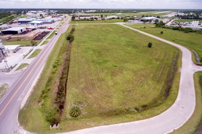
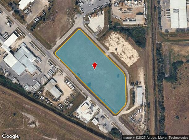
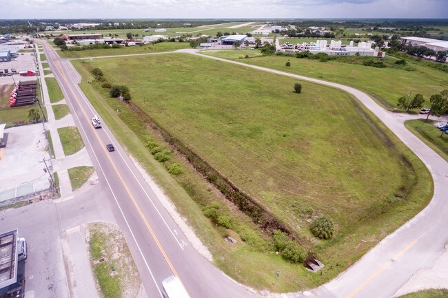
950 New Harvest Rd
Naples-Immokalee-Marco Island, FL
Immokalee Industrial
51290040007
IMMOKALEE INDUSTRIAL PARK BLK A
Industrialacreage
Collier
AH
Florida
12021C0145H
1
2024
8.42 AC
2025
Outlying Collier County
011204
Southwest Florida
DEMOGRAPHICS near 950 New Harvest Rd
1 Mile
3 Mile
5 Mile
2024 Total Population
1,577
12,753
19,610
2029 Population
1,679
13,571
21,127
Pop Growth 2024-2029
+ 6.47%
+ 6.41%
+ 7.74%
Average Age
33
32
31
2024 Total Households
460
3,350
5,052
HH Growth 2024-2029
+ 5.43%
+ 5.37%
+ 6.79%
Median Household Inc
$33,333
$36,472
$41,001
Avg Household Size
3.00
3.40
3.50
2024 Avg HH Vehicles
1.00
2.00
2.00
Median Home Value
$156,140
$162,661
$167,002
Median Year Built
1986
1988
1992
Nearby Places
Map Layers
Map Styles
 Street
 Aerial
- Restaurants
- Banks
- Shops
- Fitness
- Groceries
PUBLIC TRANSPORTATION
AIRPORT
Southwest Florida International
DRIVE
WALK
Distance
Southwest Florida International
42 min
29.3 mi
Freight Ports
Port Everglades
DRIVE
WALK
Distance
Port Everglades
111 min
97.7 mi
Nearby Properties
Address
Land Use
TOTAL SIZE
Lot Size
Zoning
Address
Land Use
TOTAL SIZE
Lot Size
Zoning
217,887 SF
564.45 AC
A-MHO
Address
Land Use
TOTAL SIZE
Lot Size
Zoning
243,268 SF
43.41 AC
RSF-3
Address
Land Use
TOTAL SIZE
Lot Size
Zoning
467,375 SF
79.87 AC
RMF-6
Address
Land Use
TOTAL SIZE
Lot Size
Zoning
150,228 SF
172.69 AC
I
Address
Land Use
TOTAL SIZE
Lot Size
Zoning
139,063 SF
22.83 AC
RSF-3
Address
Land Use
TOTAL SIZE
Lot Size
Zoning
59,982 SF
23.58 AC
A-MHO
Address
Land Use
TOTAL SIZE
Lot Size
Zoning
39,880 SF
6.52 AC
RMF-6
Address
Land Use
TOTAL SIZE
Lot Size
Zoning
152,819 SF
17.50 AC
I-FMOSD
Address
Land Use
TOTAL SIZE
Lot Size
Zoning
336.06 AC
AOPUD
Address
Land Use
TOTAL SIZE
Lot Size
Zoning
39,087 SF
3.47 AC
C-4-MSOSD
Address
Land Use
TOTAL SIZE
Lot Size
Zoning
80,165 SF
20 AC
A-MHO
Address
Land Use
TOTAL SIZE
Lot Size
Zoning
74,473 SF
10.29 AC
VR
Address
Land Use
TOTAL SIZE
Lot Size
Zoning
38,837 SF
9.41 AC
PUD
Address
Land Use
TOTAL SIZE
Lot Size
Zoning
40,862 SF
6.57 AC
PUD
Address
Land Use
TOTAL SIZE
Lot Size
Zoning
25,308 SF
5.96 AC
PUD
Address
Land Use
TOTAL SIZE
Lot Size
Zoning
33,530 SF
3.83 AC
PUD
Address
Land Use
TOTAL SIZE
Lot Size
Zoning
45,799 SF
8.70 AC
RMF-6
Address
Land Use
TOTAL SIZE
Lot Size
Zoning
59,859 SF
18.04 AC
RMF-6
Address
Land Use
TOTAL SIZE
Lot Size
Zoning
20,484 SF
3.03 AC
C-5-AOSD
Address
Land Use
TOTAL SIZE
Lot Size
Zoning
24,572 SF
623 AC
A-MHO
Address
Land Use
TOTAL SIZE
Lot Size
Zoning
4,719 SF
2.95 AC
C-4-MSOSD
Address
Land Use
TOTAL SIZE
Lot Size
Zoning
78,445 SF
6.40 AC
RMF-16
Address
Land Use
TOTAL SIZE
Lot Size
Zoning
20,566 SF
7.42 AC
C-4-MSOSD
Address
Land Use
TOTAL SIZE
Lot Size
Zoning
48,224 SF
4 AC
I
Address
Land Use
TOTAL SIZE
Lot Size
Zoning
27,951 SF
7.95 AC
RSF3
Address
Land Use
TOTAL SIZE
Lot Size
Zoning
91,633 SF
45.30 AC
I
Address
Land Use
TOTAL SIZE
Lot Size
Zoning
93,715 SF
8.97 AC
PUD
Address
Land Use
TOTAL SIZE
Lot Size
Zoning
22,386 SF
5.66 AC
Address
Land Use
TOTAL SIZE
Lot Size
Zoning
20,525 SF
4.91 AC
C1
Address
Land Use
TOTAL SIZE
Lot Size
Zoning
28,582 SF
3.83 AC
E
The World's #1 Commercial Real Estate Marketplace
Connect with us
© 2026 CoStar Group
The information above has been obtained from sources believed reliable. While we do not doubt its accuracy we have not verified it and make no guarantee, warranty or representation about it. It is your responsibility to independently confirm its accuracy and completeness. Any projections, opinions, assumptions, or estimates used are for example only and do not represent the current or future performance of the property. The value of this transaction to you depends on tax and other factors which should be evaluated by your tax, financial, and legal advisors. You and your advisors should conduct a careful, independent investigation of the property to determine to your satisfaction the suitability of the property for your needs.