Property Record
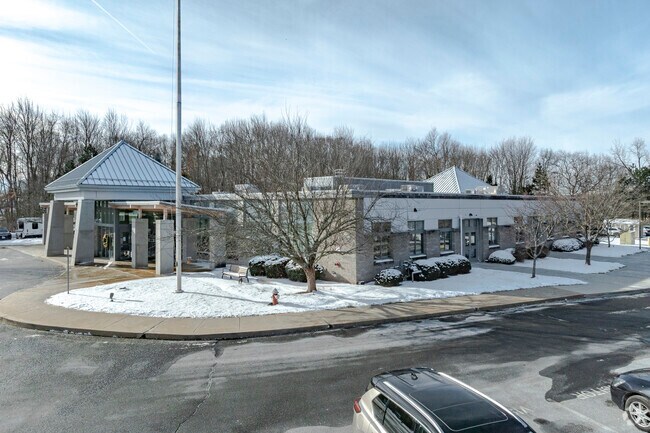
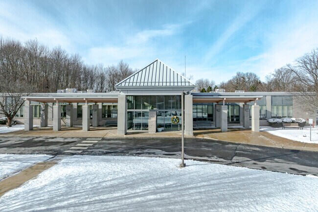
950 Slater Rd, New Britain, CT 06053

Property Detail
950 Slater Rd
Commercialofficeresidentialmixeduse
Capitol
OP
Connecticut
B and X Area of moderate flood hazard, usually the area between the limits of the 100-year and 500-year floods.
4.31 AC
2025
New Britain
2025
Hartford
416700
Hartford-West Hartford-East Hartford, CT
20,680 SF
NBRI-000002C-000000-D000902
NEARBY LISTINGS FOR SALE OR LEASE
DEMOGRAPHICS near 950 Slater Rd
1 mile
3 mile
5 mile
2025 Total Population
10,444
80,122
165,826
2030 Population
10,495
81,026
168,183
Pop Growth 2025-2030
+ 0.49%
+ 1.13%
+ 1.42%
Average Age
39
39
41
2025 Total Households
4,029
31,946
67,467
HH Growth 2025-2030
+ 0.47%
+ 1.19%
+ 1.46%
Median Household Inc
$61,959
$61,871
$81,050
Avg Household Size
2.50
2.30
2.30
2025 Avg HH Vehicles
2.00
2.00
2.00
Median Home Value
$207,517
$253,895
$292,654
Median Year Built
1961
1956
1960
Nearby Places
Map Layers
Map Styles
 Street
 Aerial
Layers
 Traffic
 Biking
Places
Listings with unknown addresses are not visible on the map
- Restaurants
- Banks
- Shops
- Fitness
- Groceries
PUBLIC TRANSPORTATION
COMMUTER RAIL
Drive
Walk
Distance
11 min
5.4 mi
Drive
Walk
Distance
11 min
5.4 mi
AIRPORT
Bradley International
Drive
Walk
Distance
Bradley International
48 min
27.7 mi
Tweed/New Haven
Drive
Walk
Distance
Tweed/New Haven
53 min
35.7 mi
Freight Ports
Port of New Haven
Drive
Walk
Distance
Port of New Haven
48 min
33.3 mi
Nearby Properties
Address
Land Use
TOTAL SIZE
Lot Size
Zoning
Address
Land Use
TOTAL SIZE
Lot Size
Zoning
61.11 AC
R20
Address
Land Use
TOTAL SIZE
Lot Size
Zoning
146,740 SF
18.23 AC
TPC
Address
Land Use
TOTAL SIZE
Lot Size
Zoning
23.64 AC
S3
Address
Land Use
TOTAL SIZE
Lot Size
Zoning
131.09 AC
OP
Address
Land Use
TOTAL SIZE
Lot Size
Zoning
19.60 AC
S2
Address
Land Use
TOTAL SIZE
Lot Size
Zoning
134,488 SF
63.26 AC
GC
Address
Land Use
TOTAL SIZE
Lot Size
Zoning
64,822 SF
9.47 AC
TP
Address
Land Use
TOTAL SIZE
Lot Size
Zoning
191,718 SF
16 AC
R40
Address
Land Use
TOTAL SIZE
Lot Size
Zoning
155,161 SF
18.18 AC
S1
Address
Land Use
TOTAL SIZE
Lot Size
Zoning
2.07 AC
CBD
Address
Land Use
TOTAL SIZE
Lot Size
Zoning
23.62 AC
A3
Address
Land Use
TOTAL SIZE
Lot Size
Zoning
117,139 SF
6.77 AC
T
Address
Land Use
TOTAL SIZE
Lot Size
Zoning
90,625 SF
0.97 AC
CBD
Address
Land Use
TOTAL SIZE
Lot Size
Zoning
0.01 AC
PR
Address
Land Use
TOTAL SIZE
Lot Size
Zoning
96,238 SF
6.75 AC
T
Address
Land Use
TOTAL SIZE
Lot Size
Zoning
14.68 AC
SIF
Address
Land Use
TOTAL SIZE
Lot Size
Zoning
2.46 AC
CBD
Address
Land Use
TOTAL SIZE
Lot Size
Zoning
138,582 SF
23.64 AC
BR
Address
Land Use
TOTAL SIZE
Lot Size
Zoning
162,470 SF
27.10 AC
R40
Address
Land Use
TOTAL SIZE
Lot Size
Zoning
78,109 SF
8.22 AC
T
Address
Land Use
TOTAL SIZE
Lot Size
Zoning
112,304 SF
10.39 AC
S3
Address
Land Use
TOTAL SIZE
Lot Size
Zoning
16.94 AC
C1
Address
Land Use
TOTAL SIZE
Lot Size
Zoning
12 AC
R20
Address
Land Use
TOTAL SIZE
Lot Size
Zoning
14,364 SF
2.72 AC
S3
Address
Land Use
TOTAL SIZE
Lot Size
Zoning
89,544 SF
6.20 AC
S1
Address
Land Use
TOTAL SIZE
Lot Size
Zoning
182,930 SF
15.70 AC
SA
Address
Land Use
TOTAL SIZE
Lot Size
Zoning
48.09 AC
CR
Address
Land Use
TOTAL SIZE
Lot Size
Zoning
288,827 SF
24.01 AC
RI
Address
Land Use
TOTAL SIZE
Lot Size
Zoning
103,886 SF
10.47 AC
BR
Address
Land Use
TOTAL SIZE
Lot Size
Zoning
74,670 SF
4.46 AC
S2
The World's #1 Commercial Real Estate Marketplace
Connect with us
© 2026 CoStar Group
The information above has been obtained from sources believed reliable. While we do not doubt its accuracy we have not verified it and make no guarantee, warranty or representation about it. It is your responsibility to independently confirm its accuracy and completeness. Any projections, opinions, assumptions, or estimates used are for example only and do not represent the current or future performance of the property. The value of this transaction to you depends on tax and other factors which should be evaluated by your tax, financial, and legal advisors. You and your advisors should conduct a careful, independent investigation of the property to determine to your satisfaction the suitability of the property for your needs.