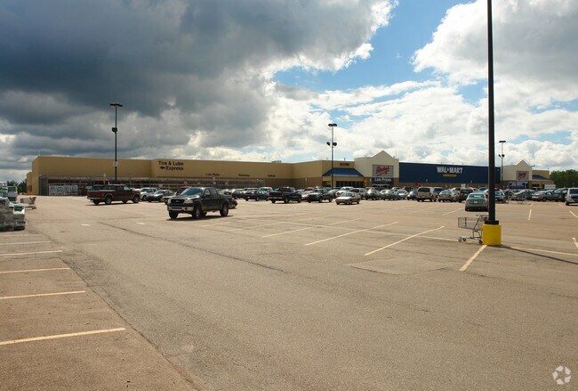
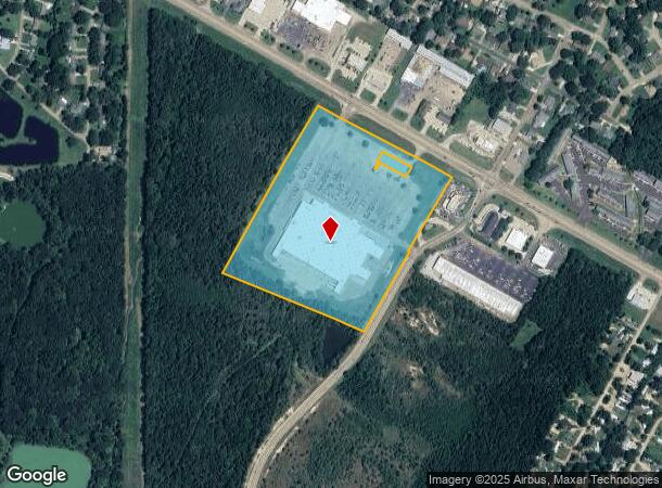
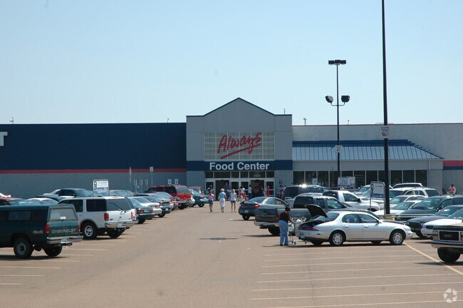
Property Record
950 W Highway 80 Rd, Clinton, MS 39056
NEARBY LISTINGS FOR SALE OR LEASE
Property Detail
950 W Highway 80 Rd
2860-0834-482
Lakeside Park
Storebuilding
BEG 1320 FT SE INT E/L BLK G LAKESIDE PARK SUBN & S/L HWY 80 SELY ALG HWY 950 FT SWLY 1100 FT NWLY 950 FT NELY 1100 FT TO POB IN S 1/2 SEC 28 & N 1/2 SEC 33 T6 R1W CITY OF CLINTON LESS 0.34 AC E/S
X
Hinds
28049C0283H
Mississippi
2024
23 AC
2025
South Jackson
010400
Jackson
188,317 SF
Jackson, MS
DEMOGRAPHICS near 950 W Highway 80 Rd
1 Mile
3 Mile
5 Mile
2024 Total Population
4,964
29,003
61,159
2029 Population
4,650
27,165
57,831
Pop Growth 2024-2029
(6.33%)
(6.34%)
(5.44%)
Average Age
35
38
38
2024 Total Households
1,894
11,143
24,058
HH Growth 2024-2029
(6.71%)
(6.66%)
(5.65%)
Median Household Inc
$49,298
$47,674
$40,164
Avg Household Size
2.30
2.40
2.40
2024 Avg HH Vehicles
2.00
2.00
2.00
Median Home Value
$148,865
$148,029
$127,329
Median Year Built
1978
1978
1975
Nearby Places
Map Layers
Map Styles
 Street
 Aerial
- Restaurants
- Banks
- Shops
- Fitness
- Groceries
PUBLIC TRANSPORTATION
COMMUTER RAIL
DRIVE
WALK
Distance
13 min
7.3 mi
AIRPORT
Jackson-Medgar Wiley Evers International
DRIVE
WALK
Distance
Jackson-Medgar Wiley Evers International
30 min
18.5 mi
Nearby Properties
Address
Land Use
TOTAL SIZE
Lot Size
Zoning
Address
Land Use
TOTAL SIZE
Lot Size
Zoning
40,255 SF
Address
Land Use
TOTAL SIZE
Lot Size
Zoning
91,933 SF
1.84 AC
Address
Land Use
TOTAL SIZE
Lot Size
Zoning
30,524 SF
10.90 AC
Address
Land Use
TOTAL SIZE
Lot Size
Zoning
314,964 SF
26.02 AC
Address
Land Use
TOTAL SIZE
Lot Size
Zoning
41,616 SF
176,418.04 AC
Address
Land Use
TOTAL SIZE
Lot Size
Zoning
90,036 SF
79.05 AC
Address
Land Use
TOTAL SIZE
Lot Size
Zoning
40.55 AC
Address
Land Use
TOTAL SIZE
Lot Size
Zoning
37,293 SF
10 AC
Address
Land Use
TOTAL SIZE
Lot Size
Zoning
32,617 SF
348,480.26 AC
Address
Land Use
TOTAL SIZE
Lot Size
Zoning
50,314 SF
115 AC
Address
Land Use
TOTAL SIZE
Lot Size
Zoning
57,673 SF
16.83 AC
Address
Land Use
TOTAL SIZE
Lot Size
Zoning
66,132 SF
8.91 AC
Address
Land Use
TOTAL SIZE
Lot Size
Zoning
148,263 SF
11.26 AC
Address
Land Use
TOTAL SIZE
Lot Size
Zoning
242,035 SF
15.80 AC
Address
Land Use
TOTAL SIZE
Lot Size
Zoning
11,950 SF
2 AC
Address
Land Use
TOTAL SIZE
Lot Size
Zoning
107,193 SF
10 AC
Address
Land Use
TOTAL SIZE
Lot Size
Zoning
40,859 SF
3.51 AC
Address
Land Use
TOTAL SIZE
Lot Size
Zoning
20,902 SF
2 AC
Address
Land Use
TOTAL SIZE
Lot Size
Zoning
15.26 AC
Address
Land Use
TOTAL SIZE
Lot Size
Zoning
126,024 SF
8.20 AC
Address
Land Use
TOTAL SIZE
Lot Size
Zoning
22,053 SF
43 AC
Address
Land Use
TOTAL SIZE
Lot Size
Zoning
96,372 SF
9.19 AC
Address
Land Use
TOTAL SIZE
Lot Size
Zoning
11,354 SF
50.54 AC
Address
Land Use
TOTAL SIZE
Lot Size
Zoning
98,531 SF
348,480.26 AC
Address
Land Use
TOTAL SIZE
Lot Size
Zoning
163,800 SF
9.10 AC
Address
Land Use
TOTAL SIZE
Lot Size
Zoning
56,960 SF
0.76 AC
Address
Land Use
TOTAL SIZE
Lot Size
Zoning
138,902 SF
8 AC
Address
Land Use
TOTAL SIZE
Lot Size
Zoning
88,733 SF
9.74 AC
Address
Land Use
TOTAL SIZE
Lot Size
Zoning
93,912 SF
7.75 AC
The World's #1 Commercial Real Estate Marketplace
Connect with us
© 2025 CoStar Group
The information above has been obtained from sources believed reliable. While we do not doubt its accuracy we have not verified it and make no guarantee, warranty or representation about it. It is your responsibility to independently confirm its accuracy and completeness. Any projections, opinions, assumptions, or estimates used are for example only and do not represent the current or future performance of the property. The value of this transaction to you depends on tax and other factors which should be evaluated by your tax, financial, and legal advisors. You and your advisors should conduct a careful, independent investigation of the property to determine to your satisfaction the suitability of the property for your needs.