Property Record
950 N Walnut St, La Habra, CA 90631
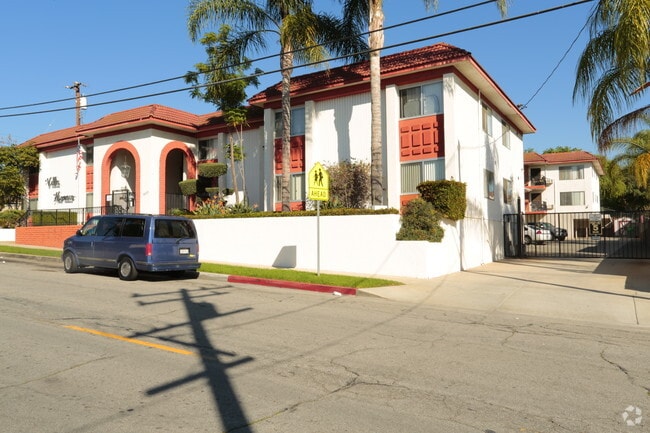

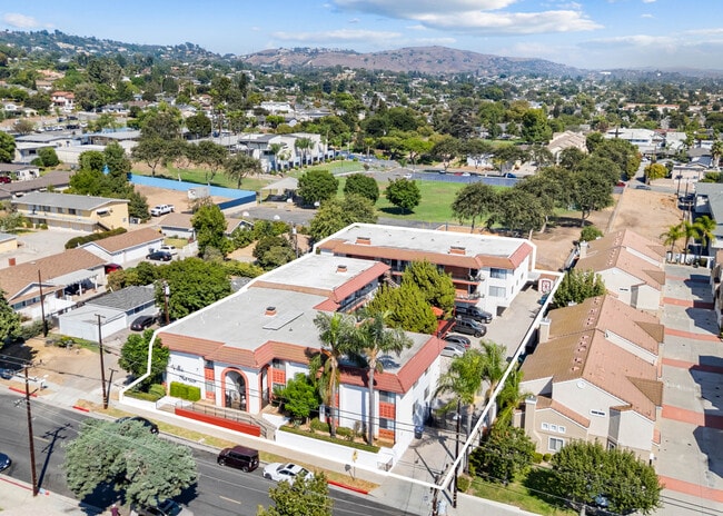

Property Detail
950 N Walnut St
017-240-22
S TWP 3 RGE 10 SEC 5 SEC 5 T 3 R 10 S 120 FT N 123.68 FT W1/2 SW1/4
Multifamilydwelling
ORANGE
R3
California
B and X Area of moderate flood hazard, usually the area between the limits of the 100-year and 500-year floods.
6
2024
0.61 AC
2025
La Habra City
001401
Orange County (California)
21,778 SF
Anaheim-Santa Ana-Irvine, CA
NEARBY LISTINGS FOR SALE OR LEASE
DEMOGRAPHICS near 950 N Walnut St
1 mile
3 mile
5 mile
2025 Total Population
24,294
124,476
372,067
2030 Population
24,262
123,742
368,994
Pop Growth 2025-2030
(0.13%)
(0.59%)
(0.83%)
Average Age
39
41
42
2025 Total Households
7,159
40,450
120,593
HH Growth 2025-2030
(0.32%)
(0.80%)
(1.03%)
Median Household Inc
$94,875
$111,001
$109,638
Avg Household Size
3.30
3.00
3.00
2025 Avg HH Vehicles
2.00
2.00
2.00
Median Home Value
$773,440
$825,629
$821,351
Median Year Built
1963
1967
1967
Nearby Places
Map Layers
Map Styles
 Street
 Aerial
Transit
 Traffic
 Biking
Places
Listings with unknown addresses are not visible on the map
- Restaurants
- Banks
- Shops
- Fitness
- Groceries
PUBLIC TRANSPORTATION
COMMUTER RAIL
Buena Park (91 Line - Southern California Regional Rail Authority (Metrolink), Orange County Line - Southern California Regional Rail Authority (Metrolink))
Drive
Walk
Distance
Buena Park (91 Line - Southern California Regional Rail Authority (Metrolink), Orange County Line - Southern California Regional Rail Authority (Metrolink))
10 min
6.4 mi
Fullerton (91 Line - Southern California Regional Rail Authority (Metrolink), Orange County Line - Southern California Regional Rail Authority (Metrolink))
Drive
Walk
Distance
Fullerton (91 Line - Southern California Regional Rail Authority (Metrolink), Orange County Line - Southern California Regional Rail Authority (Metrolink))
12 min
6.6 mi
AIRPORT
Long Beach (Daugherty Field)
Drive
Walk
Distance
Long Beach (Daugherty Field)
33 min
20.7 mi
John Wayne/Orange County
Drive
Walk
Distance
John Wayne/Orange County
32 min
22.5 mi
Ontario International
Drive
Walk
Distance
Ontario International
36 min
26.2 mi
Freight Ports
Port of Long Beach
Drive
Walk
Distance
Port of Long Beach
39 min
26.4 mi
SALE & LEASE HISTORY
LISTING DATE
SALE/LEASE

Sep 30, 2025
For Sale
Nearby Properties
Address
Land Use
TOTAL SIZE
Lot Size
Zoning
Address
Land Use
TOTAL SIZE
Lot Size
Zoning
18.57 AC
Address
Land Use
TOTAL SIZE
Lot Size
Zoning
10.49 AC
Address
Land Use
TOTAL SIZE
Lot Size
Zoning
35.82 AC
Address
Land Use
TOTAL SIZE
Lot Size
Zoning
Address
Land Use
TOTAL SIZE
Lot Size
Zoning
32.48 AC
Address
Land Use
TOTAL SIZE
Lot Size
Zoning
12.02 AC
Address
Land Use
TOTAL SIZE
Lot Size
Zoning
17.20 AC
Address
Land Use
TOTAL SIZE
Lot Size
Zoning
10.49 AC
Address
Land Use
TOTAL SIZE
Lot Size
Zoning
178,140 SF
10.88 AC
Address
Land Use
TOTAL SIZE
Lot Size
Zoning
4.28 AC
Address
Land Use
TOTAL SIZE
Lot Size
Zoning
16.88 AC
Address
Land Use
TOTAL SIZE
Lot Size
Zoning
15.11 AC
Address
Land Use
TOTAL SIZE
Lot Size
Zoning
13.40 AC
Address
Land Use
TOTAL SIZE
Lot Size
Zoning
60,710 SF
8.77 AC
LCA1*
Address
Land Use
TOTAL SIZE
Lot Size
Zoning
187,810 SF
9.09 AC
Address
Land Use
TOTAL SIZE
Lot Size
Zoning
Address
Land Use
TOTAL SIZE
Lot Size
Zoning
7.69 AC
Address
Land Use
TOTAL SIZE
Lot Size
Zoning
Address
Land Use
TOTAL SIZE
Lot Size
Zoning
31.82 AC
Address
Land Use
TOTAL SIZE
Lot Size
Zoning
18.96 AC
Address
Land Use
TOTAL SIZE
Lot Size
Zoning
96,802 SF
4.93 AC
Address
Land Use
TOTAL SIZE
Lot Size
Zoning
41,430 SF
5.85 AC
Address
Land Use
TOTAL SIZE
Lot Size
Zoning
12.86 AC
Address
Land Use
TOTAL SIZE
Lot Size
Zoning
14.86 AC
Address
Land Use
TOTAL SIZE
Lot Size
Zoning
433,176 SF
16.59 AC
Address
Land Use
TOTAL SIZE
Lot Size
Zoning
13.60 AC
Address
Land Use
TOTAL SIZE
Lot Size
Zoning
8.93 AC
Address
Land Use
TOTAL SIZE
Lot Size
Zoning
Address
Land Use
TOTAL SIZE
Lot Size
Zoning
192,740 SF
10.18 AC
Address
Land Use
TOTAL SIZE
Lot Size
Zoning
110,769 SF
6.86 AC
The World's #1 Commercial Real Estate Marketplace
Connect with us
© 2026 CoStar Group
The information above has been obtained from sources believed reliable. While we do not doubt its accuracy we have not verified it and make no guarantee, warranty or representation about it. It is your responsibility to independently confirm its accuracy and completeness. Any projections, opinions, assumptions, or estimates used are for example only and do not represent the current or future performance of the property. The value of this transaction to you depends on tax and other factors which should be evaluated by your tax, financial, and legal advisors. You and your advisors should conduct a careful, independent investigation of the property to determine to your satisfaction the suitability of the property for your needs.