Property Record
Charlie Shirley Rd, Northport, AL 35473
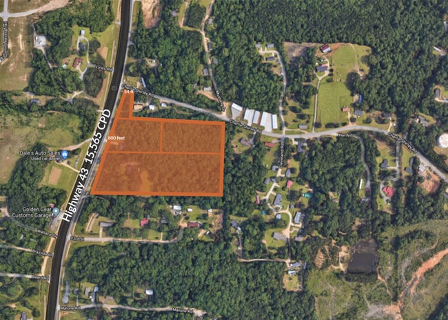
This Property Is For Sale
NEARBY LISTINGS FOR SALE OR LEASE
Property Detail
Charlie Shirley Rd
Tuscaloosa, AL
Faucett Acres 2
20-09-29-1-005-001.000
BEG SE COR LOT 10 FAUCETT ACRES NO 2; TH N 310 TO POB; TH W 560; N 311; E 560; S 311 TO POB
Timberlandforesttreesagricultural
Tuscaloosa
X
Alabama
01125C0336G
10
2025
4 AC
2024
Tuscaloosa
010206
Birmingham
DEMOGRAPHICS near Charlie Shirley Rd
1 Mile
3 Mile
5 Mile
2024 Total Population
2,271
17,532
47,134
2029 Population
2,454
19,198
52,637
Pop Growth 2024-2029
+ 8.06%
+ 9.50%
+ 11.68%
Average Age
38
39
40
2024 Total Households
844
6,689
18,463
HH Growth 2024-2029
+ 7.70%
+ 9.46%
+ 11.64%
Median Household Inc
$97,418
$94,486
$83,156
Avg Household Size
2.70
2.60
2.40
2024 Avg HH Vehicles
2.00
2.00
2.00
Median Home Value
$196,048
$244,759
$258,072
Median Year Built
1994
1998
1991
Nearby Places
Map Layers
Map Styles
 Street
 Aerial
- Restaurants
- Banks
- Shops
- Fitness
- Groceries
PUBLIC TRANSPORTATION
COMMUTER RAIL
Tuscaloosa Amtrak Station (Crescent - Amtrak)
DRIVE
WALK
Distance
Tuscaloosa Amtrak Station (Crescent - Amtrak)
13 min
7.8 mi
Freight Ports
Port of Mobile
DRIVE
WALK
Distance
Port of Mobile
249 min
206.6 mi
Nearby Properties
Address
Land Use
TOTAL SIZE
Lot Size
Zoning
Address
Land Use
TOTAL SIZE
Lot Size
Zoning
20,224 SF
19 AC
RM2
Address
Land Use
TOTAL SIZE
Lot Size
Zoning
16,920 SF
6.84 AC
AG
Address
Land Use
TOTAL SIZE
Lot Size
Zoning
4,210 SF
15 AC
RS-SD
Address
Land Use
TOTAL SIZE
Lot Size
Zoning
52,852 SF
10.21 AC
C-3
Address
Land Use
TOTAL SIZE
Lot Size
Zoning
8,952 SF
5 AC
RM2
Address
Land Use
TOTAL SIZE
Lot Size
Zoning
47,657 SF
9.53 AC
C-3
Address
Land Use
TOTAL SIZE
Lot Size
Zoning
37,553 SF
12 AC
O-I
Address
Land Use
TOTAL SIZE
Lot Size
Zoning
4,306 SF
4.60 AC
OI
Address
Land Use
TOTAL SIZE
Lot Size
Zoning
25,451 SF
4.32 AC
C-3
Address
Land Use
TOTAL SIZE
Lot Size
Zoning
5,504 SF
14 AC
Address
Land Use
TOTAL SIZE
Lot Size
Zoning
2,500 SF
160.39 AC
Address
Land Use
TOTAL SIZE
Lot Size
Zoning
7,676 SF
2 AC
RS1
Address
Land Use
TOTAL SIZE
Lot Size
Zoning
30,000 SF
5.85 AC
Address
Land Use
TOTAL SIZE
Lot Size
Zoning
25,662 SF
4.09 AC
C3
Address
Land Use
TOTAL SIZE
Lot Size
Zoning
13,775 SF
2.60 AC
C-3
Address
Land Use
TOTAL SIZE
Lot Size
Zoning
12,000 SF
4.28 AC
Address
Land Use
TOTAL SIZE
Lot Size
Zoning
15,820 SF
13.80 AC
C3
Address
Land Use
TOTAL SIZE
Lot Size
Zoning
29,800 SF
3.30 AC
C-3
Address
Land Use
TOTAL SIZE
Lot Size
Zoning
10,486 SF
2.43 AC
C-3
Address
Land Use
TOTAL SIZE
Lot Size
Zoning
32,000 SF
3.30 AC
C3
Address
Land Use
TOTAL SIZE
Lot Size
Zoning
13,791 SF
3.67 AC
C-3
Address
Land Use
TOTAL SIZE
Lot Size
Zoning
4,873 SF
3 AC
C-3
Address
Land Use
TOTAL SIZE
Lot Size
Zoning
2,960 SF
3.56 AC
C3
Address
Land Use
TOTAL SIZE
Lot Size
Zoning
12,500 SF
0.60 AC
Address
Land Use
TOTAL SIZE
Lot Size
Zoning
11,760 SF
2.33 AC
Address
Land Use
TOTAL SIZE
Lot Size
Zoning
8,100 SF
2 AC
C-3
Address
Land Use
TOTAL SIZE
Lot Size
Zoning
5,922 SF
1.04 AC
Address
Land Use
TOTAL SIZE
Lot Size
Zoning
3,486 SF
2 AC
C-3
Address
Land Use
TOTAL SIZE
Lot Size
Zoning
2,500 SF
6.20 AC
Address
Land Use
TOTAL SIZE
Lot Size
Zoning
3,311 SF
1.20 AC
C-3
The World's #1 Commercial Real Estate Marketplace
Connect with us
© 2026 CoStar Group
The information above has been obtained from sources believed reliable. While we do not doubt its accuracy we have not verified it and make no guarantee, warranty or representation about it. It is your responsibility to independently confirm its accuracy and completeness. Any projections, opinions, assumptions, or estimates used are for example only and do not represent the current or future performance of the property. The value of this transaction to you depends on tax and other factors which should be evaluated by your tax, financial, and legal advisors. You and your advisors should conduct a careful, independent investigation of the property to determine to your satisfaction the suitability of the property for your needs.