Property Record
9502 Chamberlayne Rd, Mechanicsville, VA 23116
NEARBY LISTINGS FOR SALE OR LEASE
Property Detail
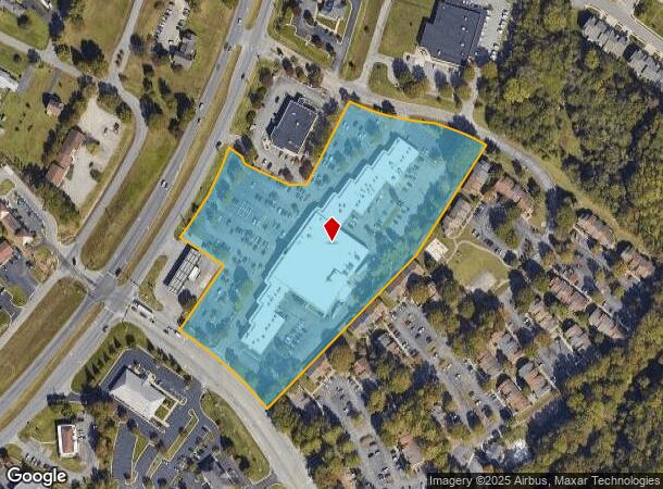
9502 Chamberlayne Rd
8706-55-8353
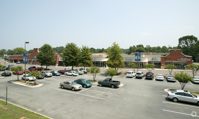
Hanover Commons
Commercialnec
HANOVER COMMONS
X
Hanover
51085C0320C
Virginia
2025
8.58 AC
2025
I-95 Chamberlayne/NE
320901
Richmond VA
73,701 SF
Richmond, VA
DEMOGRAPHICS near 9502 Chamberlayne Rd
1 Mile
3 Mile
5 Mile
2024 Total Population
5,899
30,211
85,951
2029 Population
6,321
32,254
90,158
Pop Growth 2024-2029
+ 7.15%
+ 6.76%
+ 4.89%
Average Age
41
42
41
2024 Total Households
2,205
11,149
33,793
HH Growth 2024-2029
+ 7.21%
+ 6.83%
+ 4.81%
Median Household Inc
$120,499
$113,009
$87,078
Avg Household Size
2.60
2.70
2.50
2024 Avg HH Vehicles
2.00
2.00
2.00
Median Home Value
$346,845
$338,382
$292,092
Median Year Built
1992
1993
1990
Nearby Places
Map Layers
Map Styles
 Street
 Aerial
- Restaurants
- Banks
- Shops
- Fitness
- Groceries
PUBLIC TRANSPORTATION
COMMUTER RAIL
DRIVE
WALK
Distance
16 min
8.5 mi
AIRPORT
Richmond International
DRIVE
WALK
Distance
Richmond International
23 min
14.7 mi
SALE & LEASE HISTORY
LISTING DATE
SALE/LEASE

Sep 25, 2016
For Lease
Oct 23, 2017
For Lease
Nearby Properties
Address
Land Use
TOTAL SIZE
Lot Size
Zoning
Address
Land Use
TOTAL SIZE
Lot Size
Zoning
136.01 AC
A-1
Address
Land Use
TOTAL SIZE
Lot Size
Zoning
436,148 SF
12.73 AC
B-1
Address
Land Use
TOTAL SIZE
Lot Size
Zoning
95.24 AC
A-1
Address
Land Use
TOTAL SIZE
Lot Size
Zoning
32,407 SF
1.18 AC
UMU
Address
Land Use
TOTAL SIZE
Lot Size
Zoning
2,630 SF
39.79 AC
M-2
Address
Land Use
TOTAL SIZE
Lot Size
Zoning
34.69 AC
A-1
Address
Land Use
TOTAL SIZE
Lot Size
Zoning
102,942 SF
71.86 AC
MIXE
Address
Land Use
TOTAL SIZE
Lot Size
Zoning
104,023 SF
98.16 AC
MIXE
Address
Land Use
TOTAL SIZE
Lot Size
Zoning
1,249,190 SF
139.90 AC
M-2
Address
Land Use
TOTAL SIZE
Lot Size
Zoning
2,145 SF
4.54 AC
B-1
Address
Land Use
TOTAL SIZE
Lot Size
Zoning
39.96 AC
A-1
Address
Land Use
TOTAL SIZE
Lot Size
Zoning
30 AC
A-1
Address
Land Use
TOTAL SIZE
Lot Size
Zoning
160,000 SF
25 AC
M-1
Address
Land Use
TOTAL SIZE
Lot Size
Zoning
23.23 AC
M-1
Address
Land Use
TOTAL SIZE
Lot Size
Zoning
23.60 AC
R-1
Address
Land Use
TOTAL SIZE
Lot Size
Zoning
93,484 SF
14.81 AC
M-1
Address
Land Use
TOTAL SIZE
Lot Size
Zoning
107,488 SF
9.89 AC
R-5
Address
Land Use
TOTAL SIZE
Lot Size
Zoning
63,635 SF
4.24 AC
B-1
Address
Land Use
TOTAL SIZE
Lot Size
Zoning
423,887 SF
63.71 AC
M-1
Address
Land Use
TOTAL SIZE
Lot Size
Zoning
92,190 SF
8.61 AC
R-5
Address
Land Use
TOTAL SIZE
Lot Size
Zoning
93,692 SF
4.61 AC
B-1
Address
Land Use
TOTAL SIZE
Lot Size
Zoning
3.42 AC
R-1
Address
Land Use
TOTAL SIZE
Lot Size
Zoning
115,334 SF
8.49 AC
B-3
Address
Land Use
TOTAL SIZE
Lot Size
Zoning
354,000 SF
35.70 AC
M-2
Address
Land Use
TOTAL SIZE
Lot Size
Zoning
63,543 SF
11.91 AC
B-1
Address
Land Use
TOTAL SIZE
Lot Size
Zoning
96,117 SF
40.73 AC
M-2
Address
Land Use
TOTAL SIZE
Lot Size
Zoning
Address
Land Use
TOTAL SIZE
Lot Size
Zoning
64,951 SF
8.01 AC
B-2
Address
Land Use
TOTAL SIZE
Lot Size
Zoning
32,866 SF
10.77 AC
R-1
Address
Land Use
TOTAL SIZE
Lot Size
Zoning
75,844 SF
9.32 AC
M-1C
The World's #1 Commercial Real Estate Marketplace
Connect with us
© 2026 CoStar Group
The information above has been obtained from sources believed reliable. While we do not doubt its accuracy we have not verified it and make no guarantee, warranty or representation about it. It is your responsibility to independently confirm its accuracy and completeness. Any projections, opinions, assumptions, or estimates used are for example only and do not represent the current or future performance of the property. The value of this transaction to you depends on tax and other factors which should be evaluated by your tax, financial, and legal advisors. You and your advisors should conduct a careful, independent investigation of the property to determine to your satisfaction the suitability of the property for your needs.