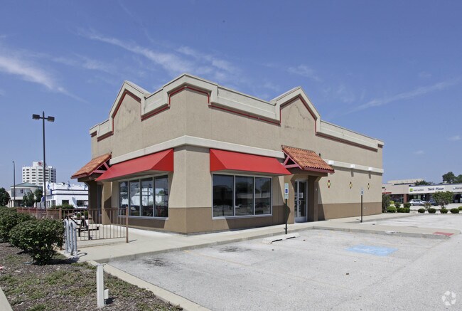
Property Record
9503 S Cicero Ave, Oak Lawn, IL 60453

NEARBY LISTINGS FOR SALE OR LEASE
Property Detail
9503 S Cicero Ave
Regionalshoppingcenterormallwithanchorstore
Cook
X
Illinois
17031C0630J
7.13 AC
2023
Near South Cook
2025
Chicago
822102
Chicago-Naperville-Elgin, IL-IN
94,610 SF
24-10-100-013-0000
DEMOGRAPHICS near 9503 S Cicero Ave
1 Mile
3 Mile
5 Mile
2024 Total Population
20,429
183,626
478,261
2029 Population
19,772
177,813
460,998
Pop Growth 2024-2029
(3.22%)
(3.17%)
(3.61%)
Average Age
42
40
40
2024 Total Households
8,296
65,033
169,663
HH Growth 2024-2029
(3.57%)
(3.46%)
(3.84%)
Median Household Inc
$66,884
$75,204
$65,054
Avg Household Size
2.40
2.70
2.70
2024 Avg HH Vehicles
2.00
2.00
2.00
Median Home Value
$211,821
$237,384
$228,078
Median Year Built
1961
1960
1959
Nearby Places
Map Layers
Map Styles
 Street
 Aerial
- Restaurants
- Banks
- Shops
- Fitness
- Groceries
PUBLIC TRANSPORTATION
COMMUTER RAIL
Oak Lawn Station (SouthWest Service - Northeast Illinois Regional Commuter Railroad (Metra))
DRIVE
WALK
Distance
Oak Lawn Station (SouthWest Service - Northeast Illinois Regional Commuter Railroad (Metra))
1 min
19 min
0.7 mi
Ashburn Station (SouthWest Service - Northeast Illinois Regional Commuter Railroad (Metra))
DRIVE
WALK
Distance
Ashburn Station (SouthWest Service - Northeast Illinois Regional Commuter Railroad (Metra))
4 min
2.3 mi
AIRPORT
Chicago Midway International
DRIVE
WALK
Distance
Chicago Midway International
10 min
5.8 mi
Chicago O'Hare International
DRIVE
WALK
Distance
Chicago O'Hare International
41 min
29.4 mi
Freight Ports
Port Milwaukee
DRIVE
WALK
Distance
Port Milwaukee
122 min
101.1 mi
Nearby Properties
Address
Land Use
TOTAL SIZE
Lot Size
Zoning
Address
Land Use
TOTAL SIZE
Lot Size
Zoning
13.59 AC
MU
Address
Land Use
TOTAL SIZE
Lot Size
Zoning
Address
Land Use
TOTAL SIZE
Lot Size
Zoning
2,155,128 SF
63.23 AC
PMD13
Address
Land Use
TOTAL SIZE
Lot Size
Zoning
798,998 SF
B3-2
Address
Land Use
TOTAL SIZE
Lot Size
Zoning
51,762 SF
4 AC
Address
Land Use
TOTAL SIZE
Lot Size
Zoning
48,792 SF
8.71 AC
RT-4
Address
Land Use
TOTAL SIZE
Lot Size
Zoning
240,300 SF
3.72 AC
Address
Land Use
TOTAL SIZE
Lot Size
Zoning
191,763 SF
15.63 AC
Address
Land Use
TOTAL SIZE
Lot Size
Zoning
292,978 SF
22.31 AC
Address
Land Use
TOTAL SIZE
Lot Size
Zoning
101,169 SF
13.07 AC
Address
Land Use
TOTAL SIZE
Lot Size
Zoning
796,454 SF
25.68 AC
PMD13
Address
Land Use
TOTAL SIZE
Lot Size
Zoning
157,787 SF
12.23 AC
Address
Land Use
TOTAL SIZE
Lot Size
Zoning
Address
Land Use
TOTAL SIZE
Lot Size
Zoning
401,021 SF
27.42 AC
Address
Land Use
TOTAL SIZE
Lot Size
Zoning
48,192 SF
2.01 AC
Address
Land Use
TOTAL SIZE
Lot Size
Zoning
139,493 SF
9.06 AC
PD 965
Address
Land Use
TOTAL SIZE
Lot Size
Zoning
61,388 SF
2 AC
Address
Land Use
TOTAL SIZE
Lot Size
Zoning
1.16 AC
Address
Land Use
TOTAL SIZE
Lot Size
Zoning
510,332 SF
23.97 AC
Address
Land Use
TOTAL SIZE
Lot Size
Zoning
149,902 SF
3.62 AC
Address
Land Use
TOTAL SIZE
Lot Size
Zoning
223,310 SF
15.67 AC
Address
Land Use
TOTAL SIZE
Lot Size
Zoning
5.66 AC
Address
Land Use
TOTAL SIZE
Lot Size
Zoning
224,089 SF
Address
Land Use
TOTAL SIZE
Lot Size
Zoning
148,474 SF
17.68 AC
Address
Land Use
TOTAL SIZE
Lot Size
Zoning
28,406 SF
1.42 AC
Address
Land Use
TOTAL SIZE
Lot Size
Zoning
36,960 SF
0.84 AC
Address
Land Use
TOTAL SIZE
Lot Size
Zoning
Address
Land Use
TOTAL SIZE
Lot Size
Zoning
82,000 SF
Address
Land Use
TOTAL SIZE
Lot Size
Zoning
470,160 SF
23.66 AC
Address
Land Use
TOTAL SIZE
Lot Size
Zoning
99,900 SF
12.45 AC
PD 1172
The World's #1 Commercial Real Estate Marketplace
Connect with us
© 2026 CoStar Group
The information above has been obtained from sources believed reliable. While we do not doubt its accuracy we have not verified it and make no guarantee, warranty or representation about it. It is your responsibility to independently confirm its accuracy and completeness. Any projections, opinions, assumptions, or estimates used are for example only and do not represent the current or future performance of the property. The value of this transaction to you depends on tax and other factors which should be evaluated by your tax, financial, and legal advisors. You and your advisors should conduct a careful, independent investigation of the property to determine to your satisfaction the suitability of the property for your needs.