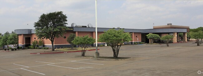
Property Record
9504 N Interstate 35, Austin, TX 78753


Property Detail
9504 N Interstate 35
Austin-Round Rock-San Marcos, TX
5.5217AC OF LOT 1 K/N SUBD
246693
Travis
Officebuilding
Texas
AE The base floodplain where base flood elevations are provided. AE Zones are now used on new format FIRMs instead of A1-A30 Zones.
1
0
5.52 AC
2025
North/Domain
041000
Austin
58,264 SF
NEARBY LISTINGS FOR SALE OR LEASE
DEMOGRAPHICS near 9504 N Interstate 35
1 mile
3 mile
5 mile
2025 Total Population
27,815
137,110
338,346
2030 Population
28,748
143,582
354,959
Pop Growth 2025-2030
+ 3.35%
+ 4.72%
+ 4.91%
Average Age
35
37
37
2025 Total Households
9,954
55,839
147,939
HH Growth 2025-2030
+ 4.06%
+ 5.49%
+ 5.54%
Median Household Inc
$55,052
$70,537
$82,729
Avg Household Size
2.70
2.40
2.20
2025 Avg HH Vehicles
2.00
2.00
2.00
Median Home Value
$352,920
$462,859
$568,574
Median Year Built
1983
1985
1990
Nearby Places
Map Layers
Map Styles
 Street
 Aerial
Transit
 Traffic
 Biking
Places
Listings with unknown addresses are not visible on the map
- Restaurants
- Banks
- Shops
- Fitness
- Groceries
PUBLIC TRANSPORTATION
AIRPORT
Austin-Bergstrom International
Drive
Walk
Distance
Austin-Bergstrom International
28 min
17.7 mi
Nearby Properties
Address
Land Use
TOTAL SIZE
Lot Size
Zoning
Address
Land Use
TOTAL SIZE
Lot Size
Zoning
230.30 AC
Address
Land Use
TOTAL SIZE
Lot Size
Zoning
702,590 SF
48.64 AC
Address
Land Use
TOTAL SIZE
Lot Size
Zoning
571,738 SF
36.06 AC
Address
Land Use
TOTAL SIZE
Lot Size
Zoning
480,823 SF
18.46 AC
Address
Land Use
TOTAL SIZE
Lot Size
Zoning
346,319 SF
6.53 AC
Address
Land Use
TOTAL SIZE
Lot Size
Zoning
311,025 SF
4.99 AC
Address
Land Use
TOTAL SIZE
Lot Size
Zoning
287,272 SF
17.68 AC
Address
Land Use
TOTAL SIZE
Lot Size
Zoning
348,496 SF
17.59 AC
Address
Land Use
TOTAL SIZE
Lot Size
Zoning
425,200 SF
2.49 AC
Address
Land Use
TOTAL SIZE
Lot Size
Zoning
314,319 SF
5.97 AC
Address
Land Use
TOTAL SIZE
Lot Size
Zoning
379,500 SF
17.99 AC
Address
Land Use
TOTAL SIZE
Lot Size
Zoning
286,276 SF
4.53 AC
Address
Land Use
TOTAL SIZE
Lot Size
Zoning
276,772 SF
4.68 AC
Address
Land Use
TOTAL SIZE
Lot Size
Zoning
299,957 SF
22.02 AC
Address
Land Use
TOTAL SIZE
Lot Size
Zoning
459,304 SF
28.36 AC
Address
Land Use
TOTAL SIZE
Lot Size
Zoning
752,804 SF
180.91 AC
Address
Land Use
TOTAL SIZE
Lot Size
Zoning
244,809 SF
5.45 AC
Address
Land Use
TOTAL SIZE
Lot Size
Zoning
270,780 SF
18.17 AC
Address
Land Use
TOTAL SIZE
Lot Size
Zoning
521,820 SF
4.68 AC
Address
Land Use
TOTAL SIZE
Lot Size
Zoning
248,325 SF
2.46 AC
Address
Land Use
TOTAL SIZE
Lot Size
Zoning
384,776 SF
22.88 AC
Address
Land Use
TOTAL SIZE
Lot Size
Zoning
233,475 SF
2.94 AC
Address
Land Use
TOTAL SIZE
Lot Size
Zoning
242,722 SF
2.72 AC
Address
Land Use
TOTAL SIZE
Lot Size
Zoning
264,401 SF
10.48 AC
Address
Land Use
TOTAL SIZE
Lot Size
Zoning
237,603 SF
8.38 AC
Address
Land Use
TOTAL SIZE
Lot Size
Zoning
374,432 SF
14.28 AC
Address
Land Use
TOTAL SIZE
Lot Size
Zoning
276,841 SF
2.77 AC
Address
Land Use
TOTAL SIZE
Lot Size
Zoning
485,377 SF
3.19 AC
Address
Land Use
TOTAL SIZE
Lot Size
Zoning
254,796 SF
11.29 AC
Address
Land Use
TOTAL SIZE
Lot Size
Zoning
277,987 SF
11.01 AC
The World's #1 Commercial Real Estate Marketplace
Connect with us
© 2026 CoStar Group
The information above has been obtained from sources believed reliable. While we do not doubt its accuracy we have not verified it and make no guarantee, warranty or representation about it. It is your responsibility to independently confirm its accuracy and completeness. Any projections, opinions, assumptions, or estimates used are for example only and do not represent the current or future performance of the property. The value of this transaction to you depends on tax and other factors which should be evaluated by your tax, financial, and legal advisors. You and your advisors should conduct a careful, independent investigation of the property to determine to your satisfaction the suitability of the property for your needs.