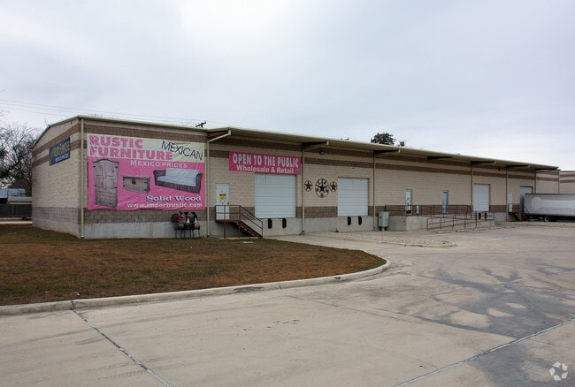
Property Record
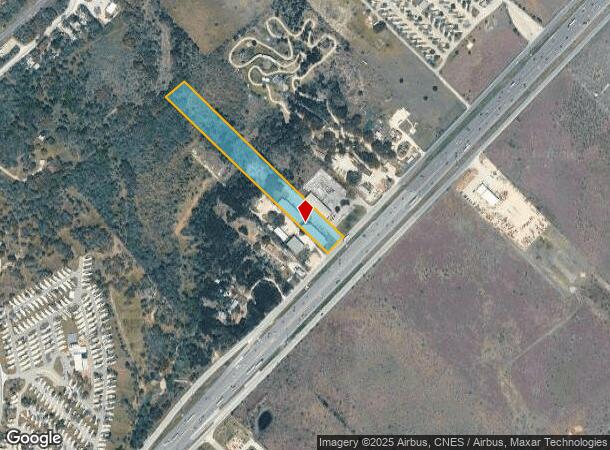
9505 N Interstate 35 N, New Braunfels, TX 78130
NEARBY LISTINGS FOR SALE OR LEASE
-
-
View all New Braunfels listings for sale on LoopNet.com
Property Detail
9505 N Interstate 35 N
74-0098-0020-00
A- 98 Sur- 1 S Craft
Commercialnec
A- 98 SUR- 1 S CRAFT, ACRES 5.286
A
Comal
48091C0295F
Texas
2024
5.29 AC
2025
Comal County
310904
San Antonio
10,000 SF
San Antonio-New Braunfels, TX
DEMOGRAPHICS near 9505 N Interstate 35 N
1 mile
3 mile
5 mile
2024 Total Population
135
3,997
26,370
2029 Population
186
5,433
35,434
Pop Growth 2024-2029
+ 37.78%
+ 35.93%
+ 34.37%
Average Age
37
39
39
2024 Total Households
56
1,627
10,063
HH Growth 2024-2029
+ 37.50%
+ 36.51%
+ 35.11%
Median Household Inc
$55,999
$62,899
$75,523
Avg Household Size
2.30
2.40
2.50
2024 Avg HH Vehicles
2.00
2.00
2.00
Median Home Value
$285,713
$354,804
$335,718
Median Year Built
2010
2010
2009
Nearby Places
Map Layers
Map Styles
 Street
 Aerial
Transit
 Traffic
 Biking
Places
Listings with unknown addresses are not visible on the map
- Restaurants
- Banks
- Shops
- Fitness
- Groceries
PUBLIC TRANSPORTATION
COMMUTER RAIL
San Marcos Amtrak (Texas Eagle - Amtrak)
Drive
Walk
Distance
San Marcos Amtrak (Texas Eagle - Amtrak)
16 min
9.5 mi
Freight Ports
Calhoun Port
Drive
Walk
Distance
Calhoun Port
176 min
143.9 mi
Nearby Properties
Address
Land Use
TOTAL SIZE
Lot Size
Zoning
Address
Land Use
TOTAL SIZE
Lot Size
Zoning
960 SF
100.89 AC
Address
Land Use
TOTAL SIZE
Lot Size
Zoning
454,563 SF
16.44 AC
Address
Land Use
TOTAL SIZE
Lot Size
Zoning
250,811 SF
23.88 AC
Address
Land Use
TOTAL SIZE
Lot Size
Zoning
326,836 SF
16.38 AC
Address
Land Use
TOTAL SIZE
Lot Size
Zoning
239,345 SF
23.41 AC
Address
Land Use
TOTAL SIZE
Lot Size
Zoning
190,554 SF
5.59 AC
Address
Land Use
TOTAL SIZE
Lot Size
Zoning
240,123 SF
8.75 AC
Address
Land Use
TOTAL SIZE
Lot Size
Zoning
146,295 SF
5.08 AC
Address
Land Use
TOTAL SIZE
Lot Size
Zoning
167,289 SF
6.04 AC
Address
Land Use
TOTAL SIZE
Lot Size
Zoning
23,897 SF
19.22 AC
Address
Land Use
TOTAL SIZE
Lot Size
Zoning
306.49 AC
Address
Land Use
TOTAL SIZE
Lot Size
Zoning
32,360 SF
90 AC
Address
Land Use
TOTAL SIZE
Lot Size
Zoning
104,695 SF
26.43 AC
Address
Land Use
TOTAL SIZE
Lot Size
Zoning
800 SF
51.92 AC
Address
Land Use
TOTAL SIZE
Lot Size
Zoning
54,862 SF
4.06 AC
Address
Land Use
TOTAL SIZE
Lot Size
Zoning
48,520 SF
4 AC
Address
Land Use
TOTAL SIZE
Lot Size
Zoning
101,931 SF
4.06 AC
Address
Land Use
TOTAL SIZE
Lot Size
Zoning
5,250 SF
18.06 AC
Address
Land Use
TOTAL SIZE
Lot Size
Zoning
50,580 SF
2.25 AC
Address
Land Use
TOTAL SIZE
Lot Size
Zoning
161,365 SF
45.60 AC
Address
Land Use
TOTAL SIZE
Lot Size
Zoning
18,878 SF
1.29 AC
Address
Land Use
TOTAL SIZE
Lot Size
Zoning
5,640 SF
15.13 AC
Address
Land Use
TOTAL SIZE
Lot Size
Zoning
26,062 SF
17.37 AC
Address
Land Use
TOTAL SIZE
Lot Size
Zoning
28,000 SF
9.19 AC
Address
Land Use
TOTAL SIZE
Lot Size
Zoning
49.23 AC
Address
Land Use
TOTAL SIZE
Lot Size
Zoning
30,000 SF
3.56 AC
Address
Land Use
TOTAL SIZE
Lot Size
Zoning
5,190 SF
83.73 AC
Address
Land Use
TOTAL SIZE
Lot Size
Zoning
62,724 SF
5.63 AC
Address
Land Use
TOTAL SIZE
Lot Size
Zoning
9,340 SF
12.37 AC
Address
Land Use
TOTAL SIZE
Lot Size
Zoning
18,756 SF
6.06 AC
The World's #1 Commercial Real Estate Marketplace
Connect with us
© 2026 CoStar Group
The information above has been obtained from sources believed reliable. While we do not doubt its accuracy we have not verified it and make no guarantee, warranty or representation about it. It is your responsibility to independently confirm its accuracy and completeness. Any projections, opinions, assumptions, or estimates used are for example only and do not represent the current or future performance of the property. The value of this transaction to you depends on tax and other factors which should be evaluated by your tax, financial, and legal advisors. You and your advisors should conduct a careful, independent investigation of the property to determine to your satisfaction the suitability of the property for your needs.