Property Record
951 Doyle Rd, Deltona, FL 32725


Save to a Folder
{{folder.Name}}
{{folder.ListingIds.length}} Properties
{{folder.ListingIds.length}} Property
Create a New Folder
Property Detail
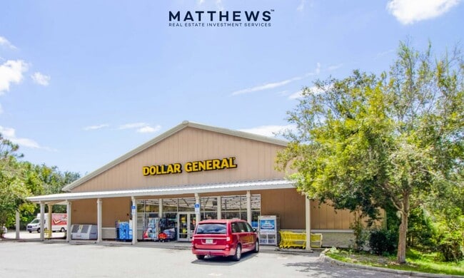
951 Doyle Rd
9106-05-00-0010
LOT 1 MAGNOLIA OAK MB 31 PG 147 PER OR 5056 PG 2619 PER OR 6858 PGS 3119-3120 PER OR 6920 PGS 1534-1535 PER OR 8492 PG 0480
Storemultistory
Volusia
C1
Florida
B and X Area of moderate flood hazard, usually the area between the limits of the 100-year and 500-year floods.
1
2025
1.42 AC
2026
Deltona
091029
Deltona/Daytona Beach
10,201 SF
Deltona-Daytona Beach-Ormond Beach, FL
NEARBY LISTINGS FOR SALE OR LEASE
DEMOGRAPHICS near 951 Doyle Rd
1 mile
3 mile
5 mile
2025 Total Population
6,280
39,180
112,836
2030 Population
6,660
41,420
120,189
Pop Growth 2025-2030
+ 6.05%
+ 5.72%
+ 6.52%
Average Age
42
41
41
2025 Total Households
2,429
14,568
42,430
HH Growth 2025-2030
+ 6.05%
+ 5.65%
+ 6.47%
Median Household Inc
$65,597
$67,277
$69,896
Avg Household Size
2.50
2.60
2.60
2025 Avg HH Vehicles
2.00
2.00
2.00
Median Home Value
$277,466
$300,585
$319,747
Median Year Built
1987
1985
1988
Nearby Places
Map Layers
Map Styles
 Street
 Aerial
Layers
 Traffic
 Biking
Places
Listings with unknown addresses are not visible on the map
- Restaurants
- Banks
- Shops
- Fitness
- Groceries
PUBLIC TRANSPORTATION
COMMUTER RAIL
Debary (SunRail - Florida Department of Transportation)
Drive
Walk
Distance
Debary (SunRail - Florida Department of Transportation)
9 min
5.2 mi
AIRPORT
Orlando Sanford International
Drive
Walk
Distance
Orlando Sanford International
28 min
16.4 mi
Daytona Beach International
Drive
Walk
Distance
Daytona Beach International
37 min
29.4 mi
Freight Ports
Port Canaveral
Drive
Walk
Distance
Port Canaveral
94 min
78.2 mi
SALE & LEASE HISTORY
LISTING DATE
SALE/LEASE

Aug 29, 2023
For Sale
Nearby Properties
Address
Land Use
TOTAL SIZE
Lot Size
Zoning
Address
Land Use
TOTAL SIZE
Lot Size
Zoning
258,869 SF
38.34 AC
P
Address
Land Use
TOTAL SIZE
Lot Size
Zoning
212,959 SF
65.31 AC
MPUDE
Address
Land Use
TOTAL SIZE
Lot Size
Zoning
123,193 SF
20 AC
01A3
Address
Land Use
TOTAL SIZE
Lot Size
Zoning
169,634 SF
12.97 AC
01B
Address
Land Use
TOTAL SIZE
Lot Size
Zoning
109,425 SF
21.84 AC
01PUD
Address
Land Use
TOTAL SIZE
Lot Size
Zoning
113,782 SF
18.52 AC
P
Address
Land Use
TOTAL SIZE
Lot Size
Zoning
64,836 SF
11.06 AC
BPUD
Address
Land Use
TOTAL SIZE
Lot Size
Zoning
139,919 SF
7.20 AC
MPUD
Address
Land Use
TOTAL SIZE
Lot Size
Zoning
93,717 SF
10.12 AC
R4E
Address
Land Use
TOTAL SIZE
Lot Size
Zoning
92,610 SF
7 AC
01B
Address
Land Use
TOTAL SIZE
Lot Size
Zoning
57,631 SF
10.27 AC
01B
Address
Land Use
TOTAL SIZE
Lot Size
Zoning
71,146 SF
3.67 AC
01B
Address
Land Use
TOTAL SIZE
Lot Size
Zoning
40,578 SF
2.51 AC
01B4
Address
Land Use
TOTAL SIZE
Lot Size
Zoning
66,453 SF
5.30 AC
01R
Address
Land Use
TOTAL SIZE
Lot Size
Zoning
78,735 SF
5.90 AC
01B5
Address
Land Use
TOTAL SIZE
Lot Size
Zoning
103,508 SF
10.68 AC
01B5
Address
Land Use
TOTAL SIZE
Lot Size
Zoning
20,077 SF
4.40 AC
MPUD
Address
Land Use
TOTAL SIZE
Lot Size
Zoning
40,717 SF
4.30 AC
01B
Address
Land Use
TOTAL SIZE
Lot Size
Zoning
45,105 SF
4.41 AC
Address
Land Use
TOTAL SIZE
Lot Size
Zoning
36,351 SF
14.06 AC
R1
Address
Land Use
TOTAL SIZE
Lot Size
Zoning
10,336 SF
2.50 AC
01A3
Address
Land Use
TOTAL SIZE
Lot Size
Zoning
22,629 SF
4.20 AC
01B4
Address
Land Use
TOTAL SIZE
Lot Size
Zoning
21,195 SF
6.04 AC
Address
Land Use
TOTAL SIZE
Lot Size
Zoning
41,944 SF
3.71 AC
01B4
Address
Land Use
TOTAL SIZE
Lot Size
Zoning
20,996 SF
2.60 AC
01B4
Address
Land Use
TOTAL SIZE
Lot Size
Zoning
24,573 SF
5.06 AC
C1
Address
Land Use
TOTAL SIZE
Lot Size
Zoning
14,174 SF
11.05 AC
R1
Address
Land Use
TOTAL SIZE
Lot Size
Zoning
32,835 SF
2.74 AC
C1
Address
Land Use
TOTAL SIZE
Lot Size
Zoning
540 AC
C
Address
Land Use
TOTAL SIZE
Lot Size
Zoning
15,486 SF
1.62 AC
The World's #1 Commercial Real Estate Marketplace
Connect with us
© 2026 CoStar Group
The information above has been obtained from sources believed reliable. While we do not doubt its accuracy we have not verified it and make no guarantee, warranty or representation about it. It is your responsibility to independently confirm its accuracy and completeness. Any projections, opinions, assumptions, or estimates used are for example only and do not represent the current or future performance of the property. The value of this transaction to you depends on tax and other factors which should be evaluated by your tax, financial, and legal advisors. You and your advisors should conduct a careful, independent investigation of the property to determine to your satisfaction the suitability of the property for your needs.