Property Record
951 Maxwell Ave, Evansville, IN 47711
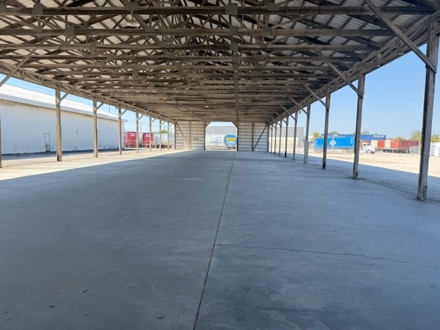
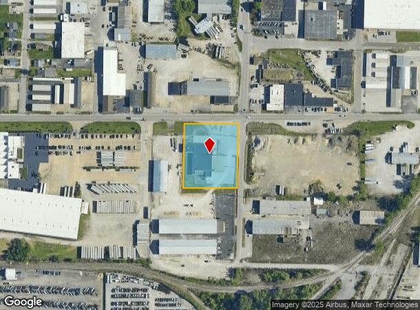
This Property Is For Sale
Current Lease Availabilities
NEARBY LISTINGS FOR SALE OR LEASE
Property Detail
951 Maxwell Ave
82-06-17-031-157.001-029
Minor Subdivision
Industrialgeneral
TIMBER TOWN L 1
X
Vanderburgh
18163C0181E
Indiana
2024
1.59 AC
2024
Northside/Airport
010207
Evansville
12,941 SF
Evansville, IN-KY
DEMOGRAPHICS near 951 Maxwell Ave
1 Mile
3 Mile
5 Mile
2024 Total Population
9,691
73,424
135,830
2029 Population
9,854
74,335
136,444
Pop Growth 2024-2029
+ 1.68%
+ 1.24%
+ 0.45%
Average Age
39
40
40
2024 Total Households
4,252
31,620
59,334
HH Growth 2024-2029
+ 1.58%
+ 1.28%
+ 0.47%
Median Household Inc
$43,951
$46,286
$49,630
Avg Household Size
2.20
2.20
2.20
2024 Avg HH Vehicles
1.00
2.00
2.00
Median Home Value
$60,988
$101,090
$127,909
Median Year Built
1947
1953
1963
Nearby Places
Map Layers
Map Styles
 Street
 Aerial
- Restaurants
- Banks
- Shops
- Fitness
- Groceries
PUBLIC TRANSPORTATION
AIRPORT
Evansville Regional
DRIVE
WALK
Distance
Evansville Regional
10 min
4.1 mi
Nearby Properties
Address
Land Use
TOTAL SIZE
Lot Size
Zoning
Address
Land Use
TOTAL SIZE
Lot Size
Zoning
84,660 SF
12.95 AC
Address
Land Use
TOTAL SIZE
Lot Size
Zoning
20,964 SF
1.35 AC
Address
Land Use
TOTAL SIZE
Lot Size
Zoning
15,233 SF
3.31 AC
Address
Land Use
TOTAL SIZE
Lot Size
Zoning
451,370 SF
23.93 AC
Address
Land Use
TOTAL SIZE
Lot Size
Zoning
51,342 SF
4.43 AC
Address
Land Use
TOTAL SIZE
Lot Size
Zoning
38,566 SF
14.66 AC
Address
Land Use
TOTAL SIZE
Lot Size
Zoning
117,580 SF
1.74 AC
Address
Land Use
TOTAL SIZE
Lot Size
Zoning
21,831 SF
3.03 AC
Address
Land Use
TOTAL SIZE
Lot Size
Zoning
165,472 SF
1.38 AC
Address
Land Use
TOTAL SIZE
Lot Size
Zoning
992,266 SF
116.92 AC
Address
Land Use
TOTAL SIZE
Lot Size
Zoning
23,108 SF
2.92 AC
Address
Land Use
TOTAL SIZE
Lot Size
Zoning
92,132 SF
1.68 AC
Address
Land Use
TOTAL SIZE
Lot Size
Zoning
23,796 SF
17.29 AC
Address
Land Use
TOTAL SIZE
Lot Size
Zoning
223,202 SF
2.28 AC
Address
Land Use
TOTAL SIZE
Lot Size
Zoning
784,971 SF
15.37 AC
Address
Land Use
TOTAL SIZE
Lot Size
Zoning
194,564 SF
24.47 AC
Address
Land Use
TOTAL SIZE
Lot Size
Zoning
87,099 SF
2.28 AC
Address
Land Use
TOTAL SIZE
Lot Size
Zoning
3,950 SF
16.77 AC
Address
Land Use
TOTAL SIZE
Lot Size
Zoning
162,726 SF
22.71 AC
Address
Land Use
TOTAL SIZE
Lot Size
Zoning
82,488 SF
1.90 AC
8
Address
Land Use
TOTAL SIZE
Lot Size
Zoning
20,286 SF
4.57 AC
Address
Land Use
TOTAL SIZE
Lot Size
Zoning
61,652 SF
15.02 AC
Address
Land Use
TOTAL SIZE
Lot Size
Zoning
184,046 SF
10.05 AC
Address
Land Use
TOTAL SIZE
Lot Size
Zoning
311,804 SF
31.94 AC
Address
Land Use
TOTAL SIZE
Lot Size
Zoning
159,074 SF
1.07 AC
Address
Land Use
TOTAL SIZE
Lot Size
Zoning
331,588 SF
0.96 AC
Address
Land Use
TOTAL SIZE
Lot Size
Zoning
1,053,789 SF
52.82 AC
Address
Land Use
TOTAL SIZE
Lot Size
Zoning
16,292 SF
6.87 AC
Address
Land Use
TOTAL SIZE
Lot Size
Zoning
8,920 SF
2.62 AC
Address
Land Use
TOTAL SIZE
Lot Size
Zoning
4,160 SF
9.22 AC
The World's #1 Commercial Real Estate Marketplace
Connect with us
© 2025 CoStar Group
The information above has been obtained from sources believed reliable. While we do not doubt its accuracy we have not verified it and make no guarantee, warranty or representation about it. It is your responsibility to independently confirm its accuracy and completeness. Any projections, opinions, assumptions, or estimates used are for example only and do not represent the current or future performance of the property. The value of this transaction to you depends on tax and other factors which should be evaluated by your tax, financial, and legal advisors. You and your advisors should conduct a careful, independent investigation of the property to determine to your satisfaction the suitability of the property for your needs.