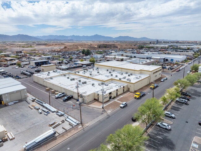
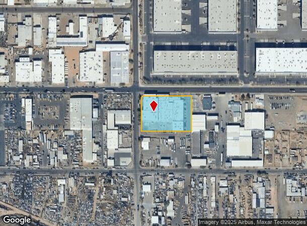
Property Record
951 W Watkins St, Phoenix, AZ 85007


This Property Is For Sale
NEARBY LISTINGS FOR SALE OR LEASE
Property Detail
951 W Watkins St
Phoenix-Mesa-Scottsdale, AZ
Shuttleworth Amd 2,3
105-37-022A
SHUTTLEWORTH AMD 2,3 MCR 23/47
Industrialgeneral
Maricopa
X
Arizona
04013C2215L
8
2025
1.71 AC
2025
SC N of Salt River
114800
Phoenix
48,583 SF
DEMOGRAPHICS near 951 W Watkins St
1 Mile
3 Mile
5 Mile
2024 Total Population
8,061
104,598
293,743
2029 Population
8,804
114,142
319,046
Pop Growth 2024-2029
+ 9.22%
+ 9.12%
+ 8.61%
Average Age
34
35
35
2024 Total Households
2,595
36,870
101,999
HH Growth 2024-2029
+ 9.52%
+ 9.87%
+ 9.06%
Median Household Inc
$30,990
$46,853
$54,354
Avg Household Size
3.00
2.60
2.70
2024 Avg HH Vehicles
1.00
2.00
2.00
Median Home Value
$288,317
$267,032
$310,629
Median Year Built
1967
1977
1976
Nearby Places
- Restaurants
- Banks
- Shops
- Fitness
- Groceries
PUBLIC TRANSPORTATION
AIRPORT
Phoenix Sky Harbor International
DRIVE
WALK
Distance
Phoenix Sky Harbor International
12 min
6.2 mi
Phoenix-Mesa Gateway
DRIVE
WALK
Distance
Phoenix-Mesa Gateway
42 min
31.7 mi
Freight Ports
Port of San Diego
DRIVE
WALK
Distance
Port of San Diego
398 min
356.3 mi
Nearby Properties
Address
Land Use
TOTAL SIZE
Lot Size
Zoning
Address
Land Use
TOTAL SIZE
Lot Size
Zoning
997,436 SF
24.84 AC
DC
Address
Land Use
TOTAL SIZE
Lot Size
Zoning
24.15 AC
Address
Land Use
TOTAL SIZE
Lot Size
Zoning
1,636,025 SF
16.50 AC
C-DT
Address
Land Use
TOTAL SIZE
Lot Size
Zoning
2,705,875 SF
133.42 AC
I-1
Address
Land Use
TOTAL SIZE
Lot Size
Zoning
577,883 SF
2.05 AC
C-DT
Address
Land Use
TOTAL SIZE
Lot Size
Zoning
781,334 SF
59.96 AC
I-1
Address
Land Use
TOTAL SIZE
Lot Size
Zoning
182,984 SF
146.12 AC
I-1
Address
Land Use
TOTAL SIZE
Lot Size
Zoning
568,512 SF
6.99 AC
C-DT
Address
Land Use
TOTAL SIZE
Lot Size
Zoning
671,803 SF
2.99 AC
C-DT
Address
Land Use
TOTAL SIZE
Lot Size
Zoning
1,378,775 SF
86.09 AC
M-H
Address
Land Use
TOTAL SIZE
Lot Size
Zoning
833,326 SF
1.31 AC
C-DT
Address
Land Use
TOTAL SIZE
Lot Size
Zoning
940,067 SF
12.22 AC
DTCBIO
Address
Land Use
TOTAL SIZE
Lot Size
Zoning
536,452 SF
0.58 AC
C-DT
Address
Land Use
TOTAL SIZE
Lot Size
Zoning
981,015 SF
2.83 AC
C-DT
Address
Land Use
TOTAL SIZE
Lot Size
Zoning
429,457 SF
9.41 AC
C-DT
Address
Land Use
TOTAL SIZE
Lot Size
Zoning
384,291 SF
2.68 AC
C-DT
Address
Land Use
TOTAL SIZE
Lot Size
Zoning
782,912 SF
1.12 AC
C-DT
Address
Land Use
TOTAL SIZE
Lot Size
Zoning
550,269 SF
2.05 AC
DTCBCORE
Address
Land Use
TOTAL SIZE
Lot Size
Zoning
727,848 SF
0.06 AC
C-DT
Address
Land Use
TOTAL SIZE
Lot Size
Zoning
569,100 SF
0.95 AC
C-DT
Address
Land Use
TOTAL SIZE
Lot Size
Zoning
222,983 SF
1.61 AC
C-DT
Address
Land Use
TOTAL SIZE
Lot Size
Zoning
440,160 SF
42.43 AC
A1
Address
Land Use
TOTAL SIZE
Lot Size
Zoning
610,451 SF
4.21 AC
C-C
Address
Land Use
TOTAL SIZE
Lot Size
Zoning
709,191 SF
52.85 AC
I-1
Address
Land Use
TOTAL SIZE
Lot Size
Zoning
631,780 SF
2.07 AC
C-DT
Address
Land Use
TOTAL SIZE
Lot Size
Zoning
441,340 SF
9.59 AC
C-DT
Address
Land Use
TOTAL SIZE
Lot Size
Zoning
645,508 SF
4.66 AC
C-DT
Address
Land Use
TOTAL SIZE
Lot Size
Zoning
359,395 SF
1.20 AC
C-DT
Address
Land Use
TOTAL SIZE
Lot Size
Zoning
792,577 SF
2.01 AC
Address
Land Use
TOTAL SIZE
Lot Size
Zoning
646,911 SF
2.07 AC
C-DT
The World's #1 Commercial Real Estate Marketplace
Connect with us
© 2025 CoStar Group
The information above has been obtained from sources believed reliable. While we do not doubt its accuracy we have not verified it and make no guarantee, warranty or representation about it. It is your responsibility to independently confirm its accuracy and completeness. Any projections, opinions, assumptions, or estimates used are for example only and do not represent the current or future performance of the property. The value of this transaction to you depends on tax and other factors which should be evaluated by your tax, financial, and legal advisors. You and your advisors should conduct a careful, independent investigation of the property to determine to your satisfaction the suitability of the property for your needs.