Property Record
9512 Croesus Ave, Los Angeles, CA 90002
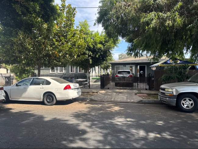


Property Detail
9512 Croesus Ave
6046-012-012
STARKS PALM TRACT LOTS 23,24 AND LOT 25 BLK O
Multifamilydwelling
Los Angeles
LCR3YY
California
B and X Area of moderate flood hazard, usually the area between the limits of the 100-year and 500-year floods.
23
2025
0.23 AC
2025
Florence-Graham
535400
Los Angeles
3,876 SF
Los Angeles-Long Beach-Glendale, CA
NEARBY LISTINGS FOR SALE OR LEASE
DEMOGRAPHICS near 9512 Croesus Ave
1 mile
3 mile
5 mile
2025 Total Population
49,126
423,541
970,659
2030 Population
48,112
413,477
951,300
Pop Growth 2025-2030
(2.06%)
(2.38%)
(1.99%)
Average Age
34
36
36
2025 Total Households
11,472
104,477
248,355
HH Growth 2025-2030
(2.42%)
(2.72%)
(2.27%)
Median Household Inc
$61,842
$62,530
$63,662
Avg Household Size
4.10
3.90
3.70
2025 Avg HH Vehicles
2.00
2.00
2.00
Median Home Value
$624,400
$654,845
$668,774
Median Year Built
1952
1953
1954
Nearby Places
Map Layers
Map Styles
 Street
 Aerial
Layers
 Traffic
 Biking
Places
Listings with unknown addresses are not visible on the map
- Restaurants
- Banks
- Shops
- Fitness
- Groceries
PUBLIC TRANSPORTATION
COMMUTER RAIL
Union Station (91 Line - Southern California Regional Rail Authority (Metrolink), Antelope Valley Line - Southern California Regional Rail Authority (Metrolink), Orange County Line - Southern California Regional Rail Authority (Metrolink), Riverside Line - Southern California Regional Rail Authority (Metrolink), San Bernardino Line - Southern California Regional Rail Authority (Metrolink), Ventura County Line - Southern California Regional Rail Authority (Metrolink))
Drive
Walk
Distance
Union Station (91 Line - Southern California Regional Rail Authority (Metrolink), Antelope Valley Line - Southern California Regional Rail Authority (Metrolink), Orange County Line - Southern California Regional Rail Authority (Metrolink), Riverside Line - Southern California Regional Rail Authority (Metrolink), San Bernardino Line - Southern California Regional Rail Authority (Metrolink), Ventura County Line - Southern California Regional Rail Authority (Metrolink))
17 min
8.0 mi
Commerce (91 Line - Southern California Regional Rail Authority (Metrolink), Orange County Line - Southern California Regional Rail Authority (Metrolink))
Drive
Walk
Distance
Commerce (91 Line - Southern California Regional Rail Authority (Metrolink), Orange County Line - Southern California Regional Rail Authority (Metrolink))
16 min
8.2 mi
AIRPORT
Long Beach (Daugherty Field)
Drive
Walk
Distance
Long Beach (Daugherty Field)
23 min
13.2 mi
Los Angeles International
Drive
Walk
Distance
Los Angeles International
20 min
13.7 mi
Bob Hope
Drive
Walk
Distance
Bob Hope
35 min
24.6 mi
Freight Ports
Port of Long Beach
Drive
Walk
Distance
Port of Long Beach
25 min
14.9 mi
SALE & LEASE HISTORY
LISTING DATE
SALE/LEASE

Jan 08, 2025
For Sale
Nearby Properties
Address
Land Use
TOTAL SIZE
Lot Size
Zoning
Address
Land Use
TOTAL SIZE
Lot Size
Zoning
587,291 SF
11.42 AC
LYHMD*
Address
Land Use
TOTAL SIZE
Lot Size
Zoning
323,368 SF
15.18 AC
LYM*
Address
Land Use
TOTAL SIZE
Lot Size
Zoning
108,598 SF
15.93 AC
LCC3*
Address
Land Use
TOTAL SIZE
Lot Size
Zoning
248,925 SF
10.91 AC
LYCB1*
Address
Land Use
TOTAL SIZE
Lot Size
Zoning
184,770 SF
VEM*
Address
Land Use
TOTAL SIZE
Lot Size
Zoning
37,867 SF
8.32 AC
COMH-B*
Address
Land Use
TOTAL SIZE
Lot Size
Zoning
116,728 SF
0.86 AC
HPCP*
Address
Land Use
TOTAL SIZE
Lot Size
Zoning
63,922 SF
1.82 AC
LCA16000*
Address
Land Use
TOTAL SIZE
Lot Size
Zoning
200,043 SF
8.68 AC
LYM*
Address
Land Use
TOTAL SIZE
Lot Size
Zoning
43,406 SF
5.67 AC
SGM2
Address
Land Use
TOTAL SIZE
Lot Size
Zoning
261,540 SF
10.85 AC
VEM*
Address
Land Use
TOTAL SIZE
Lot Size
Zoning
2.65 AC
HPM2
Address
Land Use
TOTAL SIZE
Lot Size
Zoning
97,218 SF
9.64 AC
SGM2
Address
Land Use
TOTAL SIZE
Lot Size
Zoning
498,163 SF
11.53 AC
LYM*
Address
Land Use
TOTAL SIZE
Lot Size
Zoning
201,260 SF
9.80 AC
SGM3
Address
Land Use
TOTAL SIZE
Lot Size
Zoning
127,484 SF
7.33 AC
LAM2
Address
Land Use
TOTAL SIZE
Lot Size
Zoning
811,955 SF
18.57 AC
VEM*
Address
Land Use
TOTAL SIZE
Lot Size
Zoning
104,291 SF
7.35 AC
LAR3
Address
Land Use
TOTAL SIZE
Lot Size
Zoning
134,514 SF
1.94 AC
LCM2*
Address
Land Use
TOTAL SIZE
Lot Size
Zoning
150,115 SF
10.50 AC
SGM2
Address
Land Use
TOTAL SIZE
Lot Size
Zoning
103,656 SF
6.98 AC
LCM1
Address
Land Use
TOTAL SIZE
Lot Size
Zoning
121,632 SF
1.09 AC
HPCN*
Address
Land Use
TOTAL SIZE
Lot Size
Zoning
293,886 SF
4.98 AC
SGM3
Address
Land Use
TOTAL SIZE
Lot Size
Zoning
102,719 SF
5.50 AC
LARD2
Address
Land Use
TOTAL SIZE
Lot Size
Zoning
97,204 SF
4.10 AC
COMH*
Address
Land Use
TOTAL SIZE
Lot Size
Zoning
103,896 SF
5.06 AC
VEM*
Address
Land Use
TOTAL SIZE
Lot Size
Zoning
101,562 SF
7.53 AC
LAR3
Address
Land Use
TOTAL SIZE
Lot Size
Zoning
74,882 SF
5.25 AC
LYCB1*
Address
Land Use
TOTAL SIZE
Lot Size
Zoning
137,328 SF
6.20 AC
VEM*
Address
Land Use
TOTAL SIZE
Lot Size
Zoning
52,331 SF
4.17 AC
SG
The World's #1 Commercial Real Estate Marketplace
Connect with us
© 2026 CoStar Group
The information above has been obtained from sources believed reliable. While we do not doubt its accuracy we have not verified it and make no guarantee, warranty or representation about it. It is your responsibility to independently confirm its accuracy and completeness. Any projections, opinions, assumptions, or estimates used are for example only and do not represent the current or future performance of the property. The value of this transaction to you depends on tax and other factors which should be evaluated by your tax, financial, and legal advisors. You and your advisors should conduct a careful, independent investigation of the property to determine to your satisfaction the suitability of the property for your needs.