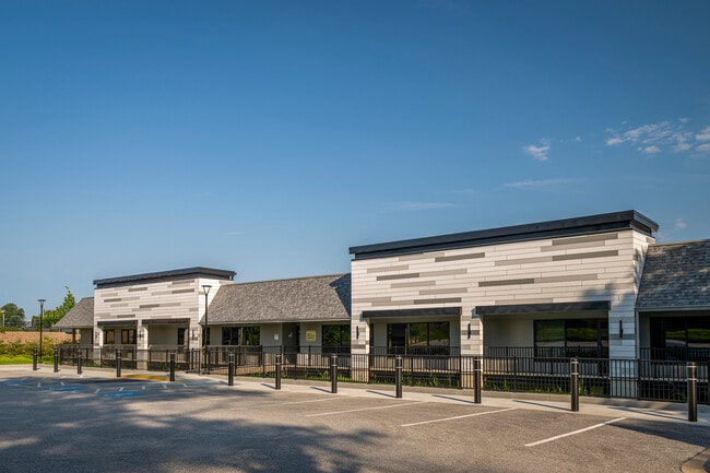
Property Record
9512 Harford Rd, Parkville, MD 21234


Current Lease Availabilities
NEARBY LISTINGS FOR SALE OR LEASE
Property Detail
9512 Harford Rd
09-0908012010
2.059 AC WS HARFORD
Officebuilding
Baltimore
X
Maryland
2400100270G
2.06 AC
2024
Baltimore County East
2025
Baltimore
491900
Baltimore-Columbia-Towson, MD
27,225 SF
DEMOGRAPHICS near 9512 Harford Rd
1 Mile
3 Mile
5 Mile
2024 Total Population
14,845
116,839
279,896
2029 Population
14,626
114,647
272,936
Pop Growth 2024-2029
(1.48%)
(1.88%)
(2.49%)
Average Age
43
41
40
2024 Total Households
6,191
47,113
111,837
HH Growth 2024-2029
(1.58%)
(2.00%)
(2.59%)
Median Household Inc
$72,347
$79,107
$75,981
Avg Household Size
2.30
2.40
2.40
2024 Avg HH Vehicles
2.00
2.00
2.00
Median Home Value
$271,837
$263,468
$264,125
Median Year Built
1969
1968
1964
Nearby Places
Map Layers
Map Styles
 Street
 Aerial
- Restaurants
- Banks
- Shops
- Fitness
- Groceries
PUBLIC TRANSPORTATION
COMMUTER RAIL
Martin State Airport (Penn Line - Maryland Area Regional Commuter Trains (The MARC))
DRIVE
WALK
Distance
Martin State Airport (Penn Line - Maryland Area Regional Commuter Trains (The MARC))
18 min
10.0 mi
AIRPORT
Baltimore/Washington International Thurgood Marshall
DRIVE
WALK
Distance
Baltimore/Washington International Thurgood Marshall
37 min
22.9 mi
Freight Ports
Port of Baltimore
DRIVE
WALK
Distance
Port of Baltimore
26 min
16.4 mi
Nearby Properties
Address
Land Use
TOTAL SIZE
Lot Size
Zoning
Address
Land Use
TOTAL SIZE
Lot Size
Zoning
1,704,075 SF
76.16 AC
Address
Land Use
TOTAL SIZE
Lot Size
Zoning
31.22 AC
DR16
Address
Land Use
TOTAL SIZE
Lot Size
Zoning
46.20 AC
DR105
Address
Land Use
TOTAL SIZE
Lot Size
Zoning
303,115 SF
7.62 AC
R-3
Address
Land Use
TOTAL SIZE
Lot Size
Zoning
204,974 SF
5.87 AC
DR16
Address
Land Use
TOTAL SIZE
Lot Size
Zoning
16.08 AC
DR16
Address
Land Use
TOTAL SIZE
Lot Size
Zoning
19.93 AC
Address
Land Use
TOTAL SIZE
Lot Size
Zoning
67,938 SF
31.72 AC
BL
Address
Land Use
TOTAL SIZE
Lot Size
Zoning
15.82 AC
BLCCC
Address
Land Use
TOTAL SIZE
Lot Size
Zoning
41,184 SF
93.14 AC
EC-1
Address
Land Use
TOTAL SIZE
Lot Size
Zoning
214,738 SF
5.92 AC
Address
Land Use
TOTAL SIZE
Lot Size
Zoning
190,826 SF
9.89 AC
Address
Land Use
TOTAL SIZE
Lot Size
Zoning
12.20 AC
DR16
Address
Land Use
TOTAL SIZE
Lot Size
Zoning
9.54 AC
DR16
Address
Land Use
TOTAL SIZE
Lot Size
Zoning
7.72 AC
DR5.5
Address
Land Use
TOTAL SIZE
Lot Size
Zoning
11.38 AC
Address
Land Use
TOTAL SIZE
Lot Size
Zoning
14.47 AC
DR16
Address
Land Use
TOTAL SIZE
Lot Size
Zoning
10.51 AC
DR16
Address
Land Use
TOTAL SIZE
Lot Size
Zoning
7.38 AC
DR16
Address
Land Use
TOTAL SIZE
Lot Size
Zoning
14.10 AC
DR16
Address
Land Use
TOTAL SIZE
Lot Size
Zoning
7.85 AC
DR5.5
Address
Land Use
TOTAL SIZE
Lot Size
Zoning
10.96 AC
DR16
Address
Land Use
TOTAL SIZE
Lot Size
Zoning
111,000 SF
29.85 AC
BM
Address
Land Use
TOTAL SIZE
Lot Size
Zoning
10.47 AC
Address
Land Use
TOTAL SIZE
Lot Size
Zoning
14.23 AC
R-5
Address
Land Use
TOTAL SIZE
Lot Size
Zoning
11.25 AC
DR16
Address
Land Use
TOTAL SIZE
Lot Size
Zoning
11.57 AC
DR16
Address
Land Use
TOTAL SIZE
Lot Size
Zoning
13.85 AC
DR5.5
Address
Land Use
TOTAL SIZE
Lot Size
Zoning
10.12 AC
DR16
Address
Land Use
TOTAL SIZE
Lot Size
Zoning
168,951 SF
18.36 AC
BR
The World's #1 Commercial Real Estate Marketplace
Connect with us
© 2026 CoStar Group
The information above has been obtained from sources believed reliable. While we do not doubt its accuracy we have not verified it and make no guarantee, warranty or representation about it. It is your responsibility to independently confirm its accuracy and completeness. Any projections, opinions, assumptions, or estimates used are for example only and do not represent the current or future performance of the property. The value of this transaction to you depends on tax and other factors which should be evaluated by your tax, financial, and legal advisors. You and your advisors should conduct a careful, independent investigation of the property to determine to your satisfaction the suitability of the property for your needs.