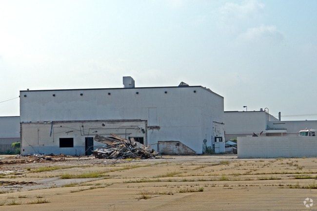
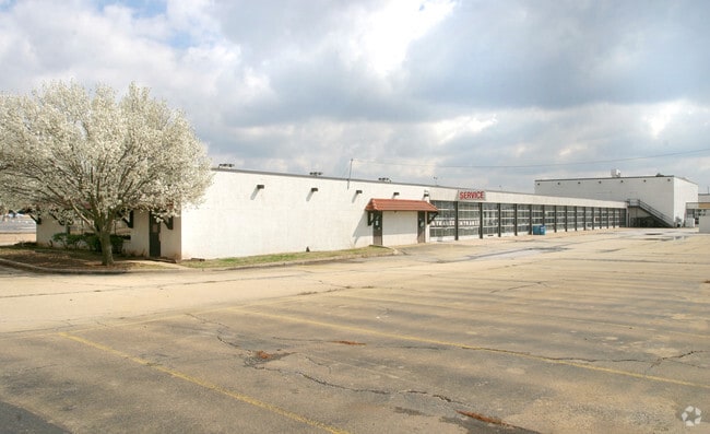
Property Record
9515 N May Ave, Oklahoma City, OK 73120
NEARBY LISTINGS FOR SALE OR LEASE
Property Detail
9515 N May Ave
178944035
Unpltd Pt Sec 25 13N 4W
Supermarket
UNPLTD PT SEC 25 13N 4W 000 000 PT SE4 SEC 25 13N 4W BEG 290FT S & 50FT W OF SE/C OF BLK 5 BURKE N RIDGE MANOR W TO E LINE BLK 17 S TO CNTR BURKSHIRE WAY E TO E LINE N TO BEG CONT 2ACRES MORE OR LESS PLUS BEG AT SE/C BLK 5 BURKE NORTHRIDGE MANOR TH W
X
Oklahoma
40109C0155H
Oklahoma
2023
5.64 AC
2024
North
108402
Oklahoma City
59,380 SF
Oklahoma City, OK
DEMOGRAPHICS near 9515 N May Ave
1 Mile
3 Mile
5 Mile
2024 Total Population
7,534
75,662
204,319
2029 Population
7,640
77,618
209,490
Pop Growth 2024-2029
+ 1.41%
+ 2.59%
+ 2.53%
Average Age
43
40
39
2024 Total Households
3,843
35,527
91,732
HH Growth 2024-2029
+ 1.43%
+ 2.69%
+ 2.67%
Median Household Inc
$67,623
$56,905
$57,385
Avg Household Size
1.90
2.10
2.20
2024 Avg HH Vehicles
2.00
2.00
2.00
Median Home Value
$194,785
$208,078
$196,079
Median Year Built
1960
1974
1976
Nearby Places
Map Layers
Map Styles
 Street
 Aerial
- Restaurants
- Banks
- Shops
- Fitness
- Groceries
PUBLIC TRANSPORTATION
AIRPORT
Will Rogers World
DRIVE
WALK
Distance
Will Rogers World
25 min
14.3 mi
Freight Ports
Tulsa Port Of Catoosa
DRIVE
WALK
Distance
Tulsa Port Of Catoosa
133 min
122.5 mi
Nearby Properties
Address
Land Use
TOTAL SIZE
Lot Size
Zoning
Address
Land Use
TOTAL SIZE
Lot Size
Zoning
366,844 SF
18.47 AC
PUD
Address
Land Use
TOTAL SIZE
Lot Size
Zoning
312,308 SF
9.76 AC
C-3
Address
Land Use
TOTAL SIZE
Lot Size
Zoning
294,583 SF
20.14 AC
PUD
Address
Land Use
TOTAL SIZE
Lot Size
Zoning
430,092 SF
17.35 AC
R-4
Address
Land Use
TOTAL SIZE
Lot Size
Zoning
358,436 SF
18.03 AC
PUD
Address
Land Use
TOTAL SIZE
Lot Size
Zoning
452,123 SF
5.64 AC
O-2
Address
Land Use
TOTAL SIZE
Lot Size
Zoning
10,922 SF
1.04 AC
SPUD
Address
Land Use
TOTAL SIZE
Lot Size
Zoning
291,228 SF
14.15 AC
PUD
Address
Land Use
TOTAL SIZE
Lot Size
Zoning
49,950 SF
3.69 AC
R-1
Address
Land Use
TOTAL SIZE
Lot Size
Zoning
158,078 SF
15.58 AC
PUD
Address
Land Use
TOTAL SIZE
Lot Size
Zoning
12,633 SF
2 AC
C-3
Address
Land Use
TOTAL SIZE
Lot Size
Zoning
21,111 SF
2.57 AC
R-4
Address
Land Use
TOTAL SIZE
Lot Size
Zoning
316,212 SF
16.36 AC
PUD
Address
Land Use
TOTAL SIZE
Lot Size
Zoning
347,288 SF
19 AC
C-3
Address
Land Use
TOTAL SIZE
Lot Size
Zoning
34,734 SF
9.07 AC
PUD
Address
Land Use
TOTAL SIZE
Lot Size
Zoning
200,836 SF
10.79 AC
R-4
Address
Land Use
TOTAL SIZE
Lot Size
Zoning
140,153 SF
13.07 AC
PUD
Address
Land Use
TOTAL SIZE
Lot Size
Zoning
7.42 AC
PUD
Address
Land Use
TOTAL SIZE
Lot Size
Zoning
203,712 SF
10.01 AC
R-4
Address
Land Use
TOTAL SIZE
Lot Size
Zoning
138,200 SF
11.95 AC
C-3
Address
Land Use
TOTAL SIZE
Lot Size
Zoning
258,068 SF
10.26 AC
R-4
Address
Land Use
TOTAL SIZE
Lot Size
Zoning
244,699 SF
11.83 AC
C-3
Address
Land Use
TOTAL SIZE
Lot Size
Zoning
287,836 SF
16.04 AC
R-4
Address
Land Use
TOTAL SIZE
Lot Size
Zoning
164,880 SF
8.95 AC
O-2
Address
Land Use
TOTAL SIZE
Lot Size
Zoning
60,238 SF
4.93 AC
PUD
Address
Land Use
TOTAL SIZE
Lot Size
Zoning
285,771 SF
8.64 AC
PUD
Address
Land Use
TOTAL SIZE
Lot Size
Zoning
182,955 SF
13.89 AC
PUD
Address
Land Use
TOTAL SIZE
Lot Size
Zoning
406,894 SF
19.99 AC
PUD
Address
Land Use
TOTAL SIZE
Lot Size
Zoning
327,372 SF
14.79 AC
R-4
Address
Land Use
TOTAL SIZE
Lot Size
Zoning
167,057 SF
2.62 AC
PUD
The World's #1 Commercial Real Estate Marketplace
Connect with us
© 2026 CoStar Group
The information above has been obtained from sources believed reliable. While we do not doubt its accuracy we have not verified it and make no guarantee, warranty or representation about it. It is your responsibility to independently confirm its accuracy and completeness. Any projections, opinions, assumptions, or estimates used are for example only and do not represent the current or future performance of the property. The value of this transaction to you depends on tax and other factors which should be evaluated by your tax, financial, and legal advisors. You and your advisors should conduct a careful, independent investigation of the property to determine to your satisfaction the suitability of the property for your needs.